7am
13.5 degrees, clear sky and still windy.
Mum
rang to say Val had had a fall and they suspect she has fractured/broken her
hip. Poor thing – hope it isn’t too bad. Sent off a text to Lorraine to get her
to pass on our love. Mum said they had a wonderful long storm last night which
dropped 6 inches of rain – so opposite to here where they forecast 6mms as
being big.
Tried
ringing Erica to let her know about Val and to see how she is going after the
flu but no answer – hope that is good news that she is up and about. Sent off a
text about Val and about meeting the Hutt River Princes.
On
with the jeans and jumpers then we headed southwest following the Hutt River to
the coast.
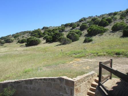
First
stop was the Convict Station at Lynton. The sun is out and it has warmed up
quickly so I took off my jumper and on with my fly net back on as the flies have
warmed up too. Wandered around reading all the plaques and all the information
in the renovated Depot.


Mum
will be interested in this bit about the real ‘Miss Anna’ from the King &
I.


Back
outside to continue with the other buildings etc.


Around
to the officer’s quarters where we look across to the Hutt River travelling beside
the sand dunes with the ocean on the other side.


Hundreds
of snails on the trail leaving silver snail trails.

Tucked
around the corner is the Magistrate’s quarters. Currently being restored.


Shady
spot for the graves though the church was never built.


Wow
this tree really has a problem.

Around
the hillside to the main station area where there is a new modern shed opposite
the original stables and barn.


Lots
of information and photos inside. Free to look at everything though donations
appreciated which is wonderful.


Great
aerial photo of Hutt Lagoon – known as Pink Lake near Port Gregory.

Well
fancy the Japanese getting that close.

The
station owners also have a farm stay/van park
here called Linga Longa.

Through
the gate and up to the original homestead. Captain Sanford certainly picked a
beautiful spot with fabulous views out to sea and across to the Pink Lake from
the verandah.


The
engraved stone above the front door. Peered in the windows then walked around
to the back and inside the house. Obviously someone souvenired some whale
bones.


Back
down the road and across to the new homestead to check out the granary/mill in
the garden.


Had
a cuppa near the barn at the picnic tables. Got a text from Lorraine saying Val
hadn’t broken any bones so she will be going home from hospital. What a relief.
She is one tough chook.
Continued
along the road then turned off into Port Gregory. Stopped at the lookout to get
some photos of ‘Pink Lake’. Hutt Lagoon was given its other name by explorer
George Grey who camped on its edge in 1839. The pink hue is due to the presence
of the carotenoid-producing algae, dunaliella salina, a source of
beta-carotene, a food-colouring agent and source of Vitamin A. The lagoon
contains the world’s largest microalgae production plant and a commercial
supply of artemia parthenogenetica (brine shrimp). Artemia is a speciality feed
used by prawn and fish farmers as well as the aquarium fish trade. The lagoon
covers a huge area – going a lot further north from here.


I
took a photo through my sunglasses as they make the pink much brighter.


Zoomed
in on the plant on the far shore.

Pretty
flowers.

Continued
along the road to Port Gregory across a causeway. Someone has set up a
‘fisherman’ by the water, complete with TV.


Still
windy but the reef offshore provides a calmer bay for the boats to moor. Port
Gregory was originally established to serve the Geraldine Lead Mine and
whalers. However, it soon became clear that it was not suitable for large
vessels.


The
sand is taking back the picnic area.

The
map shows the reef area. I think Whalebone Passage is the spot where the
Japanese submarine bombs hit.

Walked
down to the jetty where a truck is waiting for the fishermen to bring in the
live lobsters. Zoomed in on the reef then up the beach.


Watched
the cray boat come through the reef then unload the lobsters into his dingy to
bring across to the truck.


Drove
to the other side of the township – looking back over Port Gregory.

The
lake continues along way north.

Erica
rang – feeling a bit better, the cough has settled. Glad to hear that Val has
no broken bones. Erica suffering from Vertigo to and had a fall herself but
luckily she didn’t break anything.
Back
to the main road and we continued north running alongside the Lagoon. Past the
Garnet Sand mine in the sand dunes opposite the lake. The sand is red due to
the algae.
Turned
off and followed a good formed road into Lucky Bay campground. The shire has
just negotiated with the 30 odd fisherman who have shacks here and gave them a
20 year lease. We stopped at the caretaker’s office and he told us about all
the new changes here. They have just put in new toilets and picnic shelters.
$15 per vehicle per night. They had 3500 people here over Easter so no wonder
they can do the upgrade. People are catching good fish at the moment. The track
out to the beach is very sandy/boggy at the moment and he said the beach is a
bit of a mess due to recent 3 metre tides bringing in lots of seagrass and
rubbish. We drove to the end of the track before it went over the dune and had
our lunch in the shelter.


We
walked up the dune for a look. Lucky Bay is actually further along the beach.
It is protected by a reef too.


Looking
back to the shelter.

I
spotted a white thing in the distance – looks like a lighthouse.

Steve
found a broken rod – big fish or did he back over it!!

Back
to the main road and we continued north past all the open pastures with sheep
with the sand dunes between them and the ocean.

Into
Kalbarri National Park on the coast. Turned off the main road to Natural Bridge.

Too windy to spot any whales today – the humpbacks can be seen along the coast up to November.

Looking
south.


Further
north is Island Rock.


Someone
lost their hat – we are hanging onto ours as the wind is very gusty.

There
is a road around to it but we will follow the new path around to it as part of
the 3.5km Bigurda Trail.


Looking
down on Island Rock.

Around
to the lookout platform for Island Rock. The bit sticking out above the rock on the coast is Natural Bridge. Just like the rock but the top is still connected to the mainland.

The
Bigurda Trail continues as a dirt track. We turned around and went back to the
truck.

Drove
back along the track then turned off to Shellhouse & Grandstand. The
terraced rock face is the grandstand.

Fishermen
at sea though they could see a shell-shaped house on the side of the cliff,
hence the odd name. Bit hard from this angle to see what they thought was a
house.


Back
to the main road and further north, then we turned off to Eagle Gorge. There is
a better grandstand here. Around to Eagle Gorge and the beach and up the
valley.


A
falcon landed below us. I waited for him to take flight to get a photo when
another falcon landed on him/her.


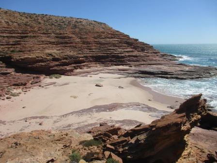
Continued
north to the next spot called Pot Alley. Named by the local cray fishermen
after losing many pots to this hazardous cove. The valley leading down to the beach
is impressive.


Steve
spotted another Natures Window.

We
walked down the rock platforms towards the beach. A big bit broke off.

Looking
up the valley and down to the beach. Don’t think we will go in for a swim!!


Great
shapes in the sandstone.

Out
onto the point looking south then north.


Walked
back up then up to check out Steve’s Window. Not so exciting view this side but
much nicer from the other side looking north.


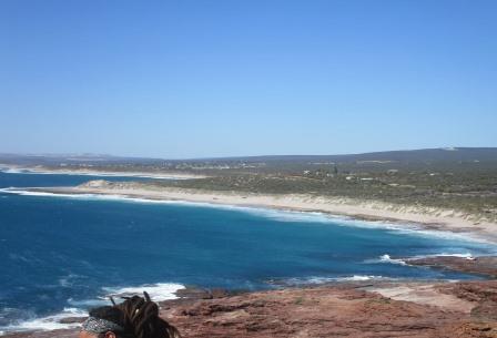
Further
north to Red Bluff.

Great
view over the beach with Kalbarri in the background from Pederick Lookout.


Continued
onto the top of Red Bluff to the Lookout.

Fabulous
view from south to north.


Zoomed
in on the Zuytdorf Cliffs.

Some
kite boarders were enjoying the strong winds today.

Drove
down onto the rocky platforms beside Red Bluff Beach for a cuppa.


A
fisherman was comfortable on the back of his ute. He hooked something but it
got away.


Zoomed
in on a truck which is near where Wittecarra Creek would reach the sea if it is
flooding. This is where the two men from the Dutch ship Batavia would have
landed.

As
we headed out a kangaroo jumped out of the bush followed by a rabbit!! Looking
back on Red Bluff.

Headed
back along the coast and back to the van via another dirt road – all roads lead
to Hutt River Providence!!
Warm
in the van as it was a lot warmer today. All quiet in the campground as we were
the only ones here.
No comments:
Post a Comment