6.30am
10 degrees, ESE cold wind. Packed up and when we started the truck up the Hema
came on then went to a blank screen with some stripes down it. Just what we
need. I pressed buttons but it wouldn’t do anything – couldn’t even get it to
shut down. Luckily I have two maps and all my notes so we headed off again.
Three
sand ridges in a row to start the morning off.


Back
onto the flats between the dunes.


Up
a rocky ridge.


Then
onto the flat running beside a sand ridge.

This
next section is marked on the map as ‘original surveyed location of the Canning
Stock Route – approximately 5 miles wide’. It has been burnt so we can see a
lot further.


Steve
spotted a bustard but by the time I got the camera he had taken off – managed
to get him.

Crested
the top of a sand ridge so Steve stopped – abruptly that is – so I could get a
photo. When you stop in the sand – you stop!!


Then
again a few sand ridges later.


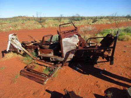
Steve
found a new truck – a burnt out landrover at the turnoff into Well 13.


Headed
into a grove of desert oaks where Well 13 is located.

The
Dekkers were just packing up camp so had a quick chat. I said our Hema stopped
and one of the chaps suggested resetting it. I had thought about that but when
we did it with the VMS it wiped all the maps. He said to take the micro SD card
out first. I did that and the Hema booted up again and we were back in action.
Said
bye and drove further through the trees to find the well. Only a depression
where the well was (at the front of the trough) and a couple of buckets are
left now. Still very chilly at the moment – hence the jumpers.
Well 13 (25 feet, 7.6m)
Canning’s team found a native well about 1.5km from
the present well site. He was unable to find suitable water near the native
well and decided a site on limestone would be more suitable. This well was once
about 8 metres deep. Between Wells 11 and 16 the Aboriginal guide, Gabbi,
reached the boundary of his tribal land and decided to return to his people.
Herbert Trotman collected letters from his men, sealed them in an empty cocoa
tin and sent it back to Wiluna with Gabbi. He addressed the tin ‘To Postmaster,
Willuna, Mulga Mail’. The mail reached Wiluna, was delivered and the tin given
back to Trotman on his return to Perth.

As
we were heading back out to the main track we heard the others chatting on
their UHF that they saw a huge herd of camels so we will keep a lookout.
More
track photos – rolling over little hills with a couple of bigger ones to keep
Steve happy. Rocks, sand and spinifex so far. Easy driving. Didn’t spot any
camels unfortunately though we can see their hoof marks on the track.


Next
section is called Ward Hills. These were named after the Ward family of
Glen-Ayle Station.


Stopped
at Well 14. Steve did a bit of checking while I put the kettle on for a cuppa.

Well 14 (51 feet, 15.5m)
Drovers coming down the stock route were continually
worried about the state of wells ahead. Aborigines often burnt them causing
great difficulties for drovers who usually had to push the cattle on to the
next well in the hope that it may be operational. Well 14 was in excellent
condition when visited by William Snell in 1929 but now only a few scattered
ruins remain.


A
memorial for Mr Weckert who passed away here in 2003 fulfilling a dream of
driving the CSR. There is a book to sign with a lot of signatures and lovely
notes. I signed ours. I noticed there were 6 before us, 4 going north and 1
came south in April (8/4, 9/4, 2 on 16/4 & 20/4) then Simon (who we met
back at North Pool – he was shortcutting via station roads to Well 9) on the
3/5, the Dekkers yesterday and us today.


Some
more shots of the track and countryside. Through one open area then into some
trees. Steve spotted an emu but he spotted us first and was off – ‘he can run
the pants of a kangaroo’ – of which we haven’t seen. I just got his rear end
heading into the trees.


Spotted
some lumps in the distance and realised they were camels so stopped so I could
zoom in for some snaps of these interesting creatures. They might be feral but
I still find them fascinating. Looking forward to my ride in Broome along Cable
Beach.


More
of the ironstone corrugation and spinifex.


Turned
off onto a track up to a ridge which is marked as a lookout on the map. Looking
up at it and what appears to be a cairn.


Parked
then climbed up the rocks. Fabulous view across the Little Sandy Desert and
Trainor Hills though they don’t stand out too well. Neither do the sand ridges
as they are covered in spinifex etc so the red ridges don’t show up. Took a
video too of the view.


Found
a hole down through the rock near the cairn.

Bit
of a lopsided shot of the cairn – of course Steve had added another one to it
while I was videoing the view.

Walked
further along the ridge and found an interesting hole – goes down a couple of
layers.


As
we climbed down we passed a cave which had a tunnel that might meet up with the
hole we saw. Good cubbyhole for animals.


On
the next flat plain we spotted 5 camels in the distance. No sand ridges at the
moment just lots of small corrugations on the ironstone stretches. A big herd
of camels were near the track hiding behind some trees. They weren’t worried
about us and stood around getting their photos taken!!


We
crossed a couple of sand ridges then Steve heard a strange grating sound so
pulled before the next one. One of the water tanks had broken away and it had
pushed the guard down onto the tyre. Steve pumped the water across into the
other tank as we had been mainly using that one so it was nearly empty. Then he
tied it up and will fix it at our next stop which isn’t far away.


A
bit further on we found someone’s dead trailer so Steve checked it out in case
there were any parts he could use. Looks like others have had the same idea as
there were bits cut out of it.

On
to Well 15 where we will stop for the night so Steve can do the repairs and I
can catch up on some blogging. 1pm 23 degrees and a cool breeze.
Interesting
reading about the murder near here.

Well 15 (22 feet, 6.7m)
Aborigines were of great value to Canning in finding
water and many of the CSR wells are near native wells. Little water was found
in them but by boring holes to a much greater depth Canning was usually able to
find a better supply from the same water reserve.
Ernest Giles passed to the north of this well during
his east-west exploration of 1876. He
was born in England in 1835. His parents migrated to Aust and he joined them in
1850, after completing his education. Giles sought a challenge away from town
life and joined a party exploring land in NSW. In 1872, Baron von Mueller, the
Australian Government Botanist, asked Giles to lead an expedition from Chambers
Pillar in Central Aust to the WA coast. Although unsuccessful, the expedition
added much to people’s knowledge of Central Aust. Giles’ next attempt started
from the Overland Telegraph Line where it crossed the Alberga River north of
the present day town of Oodnadatta. During this exploration a member of Giles’
party, Alfred Gibson, became lost and perished in what is now known as Gibson
Desert. Giles successfully crossed WA in 1875 with a party equipped with 15
camels. He discovered Queen Victoria Spring in the Great Victoria Desert after
17 days of waterless travel. He reached Perth in November and by mid January
started the return journey from the present town of Newman and reached the
Overland Telegraph Line in August 1876. Giles became interested in gold mining
and was known to be on the Halls Creek field in 1885. Prospectors often sought
his advice during his last years as a clerk at Coolgardie. Giles died in 1897
and is buried in the Coolgardie Cemetery.


It
has been restored a couple of times and they have listed the water depth on the
inside of the lid.


My
turn to raise some water for our showers. Steve took a video too. There are
holes in the bucket dear Liza – we think some are leaking rivets but the one on
the bottom is so the bucket dries out when between use so it doesn’t rust out.
The tree roots are working their way in for a drink.


Lovely
gums around here.

The
Track Care group have installed a toilet here too which I checked out. They are
not smelly as they provide lime to sprinkle of what you deposit!! Mr Spider was
guarding the entrance.

Steve
got to work on the water tank bracket repairs – lucky he brought his tools. A
good Boy Scout – always prepared. All fixed and ready to go again.
Then
he emptied 75 litres from the jerry cans on the roof into the main tank. Fuel
economy has been good.

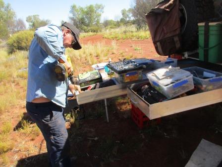
I
got some blogging done. Parked in the sun so I could recharge the laptop once I
had flattened the battery. Steve snuck a couple of photos of me hard at work –
oh yeah the flies are still annoying!! Quite hot when standing in the sun but
still cool when we are in the shade.


Under
a tree nearby is a memorial to Mr Wilkins who was murdered near here.


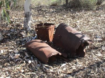
I
wandered around and found some old bits and pieces hiding in the brush.
Moved
the truck so the wind wouldn’t flap the awning and set up for the night.

Lovely
evening watching the satellites zoom across the stars. Tried my Sat Phone –
works but no messages which is good.
About
8.30 it got quite chilly, 11 degrees, though the wind has stopped. Played a few
games of Skipbo after a nice hot shower then into bed. We are sleeping well
which is good.
Map of this section of our trip.
Map of this section of our trip.

No comments:
Post a Comment