6.30am
17 degrees, clear sky. Mozzie net worked well – they are all looking at me but
can’t get in!!
The
flies are up early so on with my fly net while we pack up camp.
Headed
east onto the Talawana Track. Very sandy. No other recent wheel tracks – just
camel hoofprints.


Talawana Track
Len Beadell and the Gunbarrel Road Construction Party built
this track in late 1963 as part of the road system developed for a geodetic
survey of Australia by the Department of National Mapping. It is about 450km
from Well 23 to Newman.
Passing
the other side of the range we came past the other night.


Flat
country to the north side of us.

The
hills continue now to our left as we now run along the side of a sand ridge.

Long
straight road – as he says on his DVD – much easier to put in than corners.

Looking
at the map where Well 22 and 23 are situated I reckon the drovers would have
come straight up to Well 23 rather than the track we took to Georgia Bore. The
CSR probably adjusted when Len put the Talawana Track through.
Lovely
sloping hills around here compared to the stark rocky ones of Durba and Diebil
Hills.

Stopped
to check out Well 23 that is marked with a fuel drum. We only found a bit of
troughing and a depression in the grass where the well was.


Well 23 (19 feet, 5.8m)
Well 23 is a focal point for most travellers, not for
water but for fuel dropped by Capricorn Roadhouse on order.
Further
up that track we found the fuel dump spot. Lots of empty ones, a couple that
are quite swollen from being in a fire and a few with names on them still with
some fuel in them. I wonder how many of them get raided. When Steve’s parents
came through they had to get their fuel dropped off as they couldn’t get fuel
at the Communities like we can now.


Back
onto the TT/CSR and on to Well 24. Across salt pan area as we run beside big
hills with a cute little rock pile beside it.


A
herd of camels were lolling around near the road – run to the hills!!


Across
a wide flat area that didn’t have any spinifex on it then back into the
spinifex again.


Had
to detour off the track which was washed out and follow another newly made
track up on the higher bit.


Interesting
hills – nice for a change from sand ridges.


Through
a low area with lots of trees the out on the flat again.


Running
along parallel with the sand ridges again.

Another
badly eroded section that requires a detour.
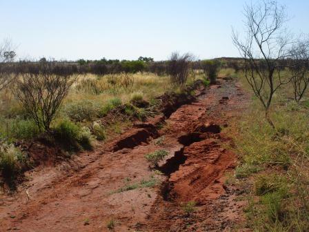

Then
down into the track again which is more like a creek bed now.

Turned
off the main track to find Well 24. First we had to cross a creek. First Steve
checked it was safe to cross then over we went. Took a quick video of that as
it was all good.


Lots
of pretty flowers around.

Big
salt pan area with lots of layered rock hills around.


I
got out and walked to try and find where the well was. Steve checked out the
track to make sure it was ok then followed me around.

We
walked out to the creek again then back and through the shrubs looking for the
well. The water is lovely and clear but I didn’t try it to see how salty it
was.


I
found it further over behind some trees. It was just a green pool but there was
a sign next to it.


Well 24 – Curara Soaks (33 feet, 10m)
Canning was shown this site by his Aboriginal guides.
The native soak was a meeting place for Aborigines. In 1952 when Wally Dowling
was bring down a mob of cattle from Billiluna, he discovered the body of an
Aboriginal boy down the well. After removing and burying the child’s body, Dowling
had no option but to continue drawing water for the stock and the droving team.
Steve
tossed a rock in and he thinks he is still pretty deep.

Back
out to the main track and continued along. Spotted some camels resting but they
didn’t stay sitting for very long.


We
have left the rocky hills and back into the red sand ridges again as we
approach the turn off back onto the CSR proper.

Steve
put the sign back up pointing the way to Windy Corner which is 200km to the
east and meets the Gary Highway (another of Len Beadell’s). We could have
called this corner Windy too as it is blowing a gale. Another sign is buried in
the sand. No one has been on that part of the Talawana Track for a while. Decided
this was a good enough spot to stop for a cuppa as we haven’t seen anyone at
all.


We
are now heading into the Gibson Desert according to my maps. 10.30am and 30
degrees though the wind is cool so it is very pleasant.
Two
kilometres further on we hit softer sand.


I
started to video then we reached the end where water has covered the track. We
backed up to where the ground was firmer then I walked back to take photos
while Steve followed a detour track around to the right. Someone has driven
across recently but we won’t be.

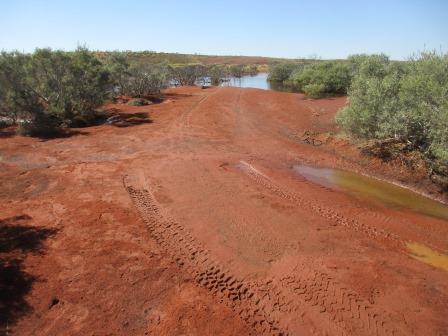


Lots
of water – looking from left to right.


This
is where we turned around.

Steve
came back and said the track continues around a dune and then up the hill
further around from the other exit we could see so off we went.


Looking
across the low land where the water is sitting. There is a lot more further
around.


Up
onto the sand ridge where we stopped to look over all the wet land trapped by
the sand ridges. Took a video.

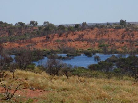

A
bit further on we found a gorge and you can see the water sitting in the basin
in the distance. On the other side (but I didn’t take a photo) you could see a
big white salt lake area running alongside another sand ridge.

Continued
along on the flat spinifex covered ground with a few salt pans here and there
for a long. A little quail flew out of the grass flapping his little wings like
mad but he was too quick for me to get a photo. Alongside a ridge before
turning to cross over it.


Steve
said there is something dead in the bush over there – I thought he meant an
animal but it was an old fuel tank. Got a photo of it as we went up the dune in
2nd gear but oops should have put it into 1st so he had
to have a second go – there goes the reputation again! Got a video of that too
– lots to show the boys.


Next
was a very eroded section that we slowly crawled along in low range 4WD – a bit
of scraping underneath the truck!!


More
scraping so Steve got out to check the track and then we found a way up onto
the flat bit to make a detour track. After a bit we found other wheel tracks so
we must have missed the original detour section.


Back
to the edge of the sand ridge for a while. Though some softer soil but ok then
up and over another sand ridge which I videoed. No messing about this time – up
in first. When we looked back we could see a lot more water in the middle than
we could see from the track.

Continued
on heading to Well 25 when again the water is across the road. Took a video of
the wet scene stopping our progress further north. We aren’t far from the well
but we won’t be seeing it but here is the information. There is a sand ridge on
each side which must be making it into a basin where the water has pooled
around the Well area.


Well 25 (37 feet, 11.3m)
This well was originally about 12 metres deep. It was
not restored by Snell because of a shortage of timber but was later rebuilt by
Canning in 1930.
The
map of the area we just came over from Georgia Bore and the end of the trail
just before Well 25 (the big white dot) on the Hema.


We
backed up a far bit where Steve had seen some wheel tracks heading off
hopefully around the wet area. Maybe the Rangers have pushed a track around the
wet areas. He went for a walk to check it out but it didn’t go far till it
disappeared into more water. He said it was boggy off the track too and got mud
all over his boots.


Back
to the main track where we drove along till we found a shady tree to have
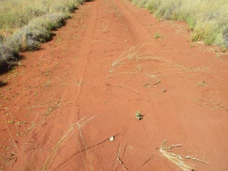
lunch.

Interesting
mushrooms are appearing in the middle of the road.

Headed
back then Steve noticed another track heading off so of course we followed that
one too.

It
was only fresh and went up and over spinifex etc then came a sand ridge. We
decided to give it a go and after 3 attempts made it up the first one as we had
to bounce over the spinifex etc. Video of that of course.

Back
on the flat bouncing along.

Made
it to the top of the next one but then bogged down so the Treds got their first
use and we were on our way again. Another video – will have lots to show the
boys.

It
appears the track is heading straight to the next spot on the main track.
Unfortunately they should have run along the base of the next ridge to get to
the track as we ended up in a basin.


Steve climbed up and spotted the track so we turned around and made our own short track to the main CSR track. Turned left back towards Well 25 in case we can get to it from this end.


But
we didn’t get far before the water stopped us again.

We
turned around to see if we can continue north now. No wheel tracks on this part
of the CSR. Took a video as we climb over a couple of sand ridges.

We
climbed another ridge and there was more water in front of us. Zoomed in on the
ridge on the other side but what lay ahead of that. Another video of the other
detour track down to the water.


The
other track maker had come out at the top of this ridge and came down onto the
straight heading to the water as we can see their wheel tracks. Doesn’t appear
to be any coming back so we presumed they pushed on. Maybe it was the rescuers
who had to pull the people out we heard about. As we don’t want to be stuck we
turned around.
Headed
back along the CSR till we found our track then headed back to the new detour
track.

Unfortunately
no one has been up from this side so after one attempt we realised we needed to
do some ground work first to make the bumpy climb easier. Video of two attempts
before we made it over.


The
next one was a lot harder as the growth was thicker this side. We tried the
track we came down then tried a different approach in high and low range. Did
lots of filling up holes with spinifex and dead branches to try and smooth out
the track. Backed up for a longer run off and eventually made it to the top but
then bogged down. Out with the Treds again and off we went. Lots of videos.
Another
difficult climb – 3 attempts and then down the other side. I took video from
the top of the ridge this time.
Across
the spinifex flat and back onto the CSR south of Well 25 again. I for one am
glad to be back on the track!!

Going
back over the sand ridges seemed very easy now. At least Steve is seeing what
the ridges are like to go over from North to South – he says ‘very easy’. A
couple more videos – glad I have spare batteries for my camera.

Back
on the open flat again with the hills on our left. An interesting valley.


Sadly
we spotted 4 dead camels not far off the road but didn’t stop this time.
Obviously the Rangers are out working at the moment.
Just
a bit further I noticed a lone camel at the base of the hill. Obviously
wondering where his herd has gone!

The
‘racing’ birds are having a ball as we zoom along this flat section doing
50kph. Wish I could video them – they are amazing.
Back
at last to Georgia Bore and into our camp spot again. No one else is here
again. What a day. So glad we got back ok. Bit too much adventure for me but
Steve had all the faith in his trusty Nissan and of course his skills which I
am very grateful that he is so competent and so cool headed.

No comments:
Post a Comment