It
was a warm night and still.
Up
early – that rooster gets up too early!! A few clouds about. Lara said it is
going to get down to 9 degrees tonight here and at Wiluna – ouch. Maybe we need
another blanket – just more clothes as there is no room for another blanket. We
are full up – 160 litres of water and 160 litres of diesel in the truck with a
further 120 in jerry cans on the roof. Let alone all the food and clothes,
cooking gear, tools & detecting gear.
Got
the final bits packed in and gave the van a quick clean. Hooked up and moved
the van to its new home for the next 6 months. Will be strange to not have my
comfortable van to live in – and the inside toilet!! Many thanks to Ross and
Lara for letting us leave the van here.

Said
goodbye to everyone and headed off at 9am. Set the trip meter to record the
whole trip till we return in 6 month’s time.
Stopped
at Mt Yagahong for a cuppa. Suppose to look like an emu on its side that has
been attacked by dingoes – poor thing.


We
are taking a ‘short-cut’ to Wiluna via the Youno Downs Road – good road, better
than the Meeka-Sandstone one. Spotted an emu up ahead and managed to get a
photo before he disappeared into the trees.

There
were a few goannas wandering across the road and the meandering cattle.


Youno
Downs Station have made good use of an old windmill.

Crossed
over a gated haul road going north and the road south to Gidgee Gold Mine. The
road then meandered through some small hills then onto red sand ridge country
and a long straight road.

Onto
the Sandstone-Wiluna Road and back into quartz and ironstone country. We are
counting the rum and beer bottles along the road. Passed a couple of mining
areas and man-made hills. Lots of dead cars too as we get closer to Wiluna.

Onto
the Goldfields Highway for 13km into Wiluna. Stopped at the Information Park
for lunch with the ‘Last Nomads’.


Checked
out the information boards about the Canning Stock Route (CSR) and the plaque
about Alfred Canning.


Our
route from Wiluna to Halls Creek.

I have copied the information
from the map we purchased on the CSR by Westprint Maps.
Canning Stock Route History
In 1884 Nat Buchanan (born 1826 in Ireland was known
as the King of Drovers) walked 4000 cattle from Richmond in Queensland to stock
Ord River Station, 170km north-east of Halls Creek. Buchanan had previously
been in charge of the largest movement of cattle ever seen, when in 1881-82, 20,000
head were moved in 10 mobs with 70 drovers from Richmond to Glencoe and Daly
River Stations in the Northern Territory. Patsy Durack stocked Argyle Downs in
1885 and the MacDonald family made one of the world’s longest cattle drives
from Goulburn in NSW to Fossil Downs near Fitzroy Crossing arriving after three
years on the track in 1886. Meat became scarce in the southern goldfields
because cattle from East Kimberley were banned from the normal coastal stock
routes and shipping movements in an effort to stop the spread of cattle tick.
Ticks were introduced with Zebu cattle imported to Australia in 1872. Its
effect was devastating, causing fever and death. Even the pitted hides couldn’t
be sold. To reduce fever, cattle walked into waterholes, turning them red with
blood-stained urine. This disease was called Red Water Fever. Politician and
former cattleman, James Isadell, put the case from East Kimberley cattlemen for
a stock route to the southern goldfields. Cattlemen knew that ticks would not
survive the heat and dryness of a desert crossing and could see that a stock
route would allow them to again run viable properties. Government Surveyor,
Alfred Canning, was appointed to carry out the initial survey of a proposed
route. His second-in-command, Hubert Trotman, was an experienced bushman having
spent several years with Canning surveying the rabbit proof fence. Others were
chosen for their experience - Joe and Michael Tobin were bore experts; Tom
Burke and Otto Baumgarten, camel handlers; Edward Blake, a cook and Robert
Moody, a general hand.
Alfred Wernam Canning was born at Campbellfield, north
of Melbourne, in 1860. He started work in NSW as a cadet surveyor and in 1893
joined the WA Dept of Lands and Survey. In 1901 he was given the task of
surveying a route for the Rabbit Proof Fence. This survey of about 1800 km from
the southern coast to a point south of Broome took 4 years to complete and was
one of the world’s longest continuous surveys at that time. In 1906 Canning was
asked to survey a stock route from Wiluna to Halls Creek through 1500km of
trackless desert. He worked almost continually for the next four years
surveying and building the stock route. At the age of 70 Canning was asked to
supervise well reconditioning partially completed by William Snell. Canning was
76 when he died in Perth in 1936.
The party left Day Dawn on May 7, 1906 and followed
John Forrest’s track of 1874 to Weld Spring. Captive Aborigines were forced to
find water when the group became desperately thirsty. They arrived in Halls
Creek on October 30, 1906. In February 1907 they left for the return journey
confident that sufficient water sources were located for their task. In April
an Aborigine was killed during an attack on Michael Tobin. Tobin also later
died. Canning’s party reached Perth in July.
Stores for the well sinking expedition consisted of
more than 100 tonnes of food and equipment, loaded onto 4 wagons and 70 camels.
The wagons travelled to Goodwin Soak, about one quarter of the way to Well 51.
More than 250 goats were bought to supply fresh meat for the team of 30. The
men were divided into three groups – one to put down bores to provide water;
the two following teams dug the well around the bore casing, removing it for
use on the next wells. It took about 8 days to complete a well. This included
cutting bush timber for all the woodwork and fencing, assembly of the iron
stays, handles, buckets, whip poles and troughing. It took 14 months to finish
31 wells and reach Halls Creek. The group arrived back at Wiluna in April 1910
after completing a further 20 wells.
Canning’s wells were identical except for their depth.
This assembly line concept assured the most efficient use of manpower in
construction and also in the prefabrication of steelwork and loading of freight.
It was also of benefit to drovers who knew their quick and efficient methods of
watering stock would work on all wells. Drovers carried a canvas bag, some
holding as much as 200 litres of water. This they attached to a steel cable
running through pulleys to a horse or camel. With one man walking the camel and
the other emptying the water bag, a large amount of water could be raised.
Drovers called this ‘whipping’. After WW2 engine driven pumps were used by
drovers from Billiluna Station. Mobs were about 500 beasts each drinking about
50 litres a day.
Wiluna
Wiluna, located on the edge of the Little Sandy
Desert, was gazetted as a township in 1897 after gold was discovered near Lake
Way. Larger mines opened in the 1930s and the population great to about 3000
with many working in the ‘Big Mine’, the largest in the Southern Hemisphere,
treating about 55,000 tons of ore a month. At its peak in the 1930s Wiluna had
12 taxis, 5 sporting ovals, 3 swimming pools, 5 dentists, 3 soft drink
factories, 4 hotels, and air service and a railway line. The Weeloona (name
Wiluna came from) Hotel claimed to have the longest bar in the world. After the
mine closed in 1947 the population dropped to 1000.
We
rang Jon, Mum & Dad to say we are heading off on our next adventure. Left
messages for Daniel, Erica & Terry as they didn’t answer the phone. Will
ring them all again when we get phone reception in Halls Creek in about 3
weeks.
Topped
up the fuel tanks at the servo. Great signs at the servo. We will be coming
back via the Gunbarrel Highway.


Headed
north out of town on a nice wide mining road. Stopped for a photo of each of
the CSR signs.


Turned
off and went along a narrow corrugated track to Well 1. There is water down the
well but the tanks are rusted out. No information signs but there is a No. 1 on
the tank.
Well 1 (45 feet, 13.7m)
Alfred Canning sited this well so that the stock route would pass on the western side of Wiluna and join the North West Stock Route at Nigarra Well about 12kms further south. Well No. 1 was completed in early April, 1908.


Nice
neat work laying the timber down the well.

The
windmill and old troughs.


Lots of nasty ‘goat head’
thorns.

Back to the main road and
further north to the turnoff to North Pool. A lovely waterhole surrounded by River
Red Gums. Parked up with ‘pool views’ just as another vehicle pulled in.
North Pool – Water 1A
Canning used waterholes as part of the stock route
water supply. Drovers enjoyed the break from the exhausting job of whipping
water from the wells. Few waterholes were classed as permanent so wells were
always placed at appropriate distances allowing waterholes to be by-passed if
dry.


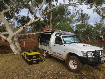
Only 3pm so plenty of time to
potter about setting up and sorting out where we want things now we are
actually living in the truck. Kitchen one side, bedroom the other. Only pulled
the bedside awning out to keep any dew off the boxes etc. It is very windy at
the moment as clouds are coming over.

Our bed is ready to go and
around the back is the shower, toilet and the green bucket between the wheels
is the washing machine – water, detergent and lots of bumpy roads to do the
agitating!! Just got to be careful not to lean on the dusty bags!!


Packed the mobile phone away
and got out the computer to keep on top of my blog. Luckily I didn’t throw away
a folder Jon was given when he received the RSL Youth Grant for his BMX as it
is perfect for this trip.

Drinks chatting with the
other chap, Simon – he is a bird enthusiast and is writing a book but he is
only going up to Well 5. Dinner overlooking the pool listening to all the birds
chirping. Beautiful sunset to finish off our first day on the Canning Stock
Route.

Played a few games of Skipbo
then a nice warm shower as the wind has died down now. The sky cleared as the
moon came up.
Map of this section of our trip.

No comments:
Post a Comment