6.30am
13.5 degrees, still and clear sky. Lovely sunrise over the sand ridge.


It
warms up quickly once the sun is up. By 6.40am it was 15.5 degrees.
Steve
found this interesting ‘tomato-looking’ thing near our camp. It has some nasty
spikes.


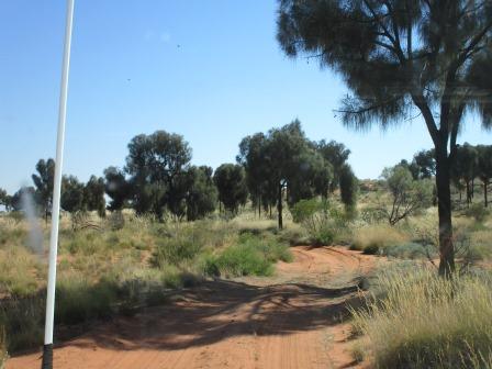
Packed
up and headed back onto the CSR. Straight up and over our first ridge for the
morning and it was a double one. Nice view from the other side looking towards Terrace
Hill where Onegunyah Rockhole is (near the south west end of Lake
Disappointment). A bustard flew out of the grass as we drove by.


Onegunya Rock Hole – Terrace Hill
Canning named this feature because of the peculiar
rock terraces found on the hillside above the rock hole.
Through
the grassy track to the base of Terrace Hill and a short walk through the grass
to the Rockhole. I changed back into long pants this time – no more scratchy
legs for me.


Just
as we came up to the rockhole an owl and a heap of little finches flew out of
the tree. Luckily the owl just went to a tree above and sat their patiently
while I took a photo. Some of the finches settled for a moment for a photo too.


Not
much water in the rockhole but enough to keep the finches, hornets and bees
happy. And by the looks of the dung around here, the camels are happy too.


Found
some art under an overhang to the right. There was a cave too but no paintings
in there.


I
found a snake skin – no snake in sight which was good.

We
climbed up Terrace Hill, not very high but it gives a good view back across the
flat plain to Diebil Hills. Then around to a sand ridge – beyond that is Lake
Disappointment. Over the rest of the rocky hill.


Back
at the truck I found a camel pad impression – big hoof.

Back
out to the CSR. After we crested another sand ridge I took a photo of the
northern side – doesn’t seem as much vegetation on this side.

Two
camels were beside the road and stood there for a photo then as they wandered
off I took a video of them. There were about 20 further over on the right.

Pulled
up to check out a dead Mitsubishi just before a sand ridge. It is now a place
for notes from travellers!


I
climbed up the sand ridge to take a video of Steve coming up. Made it look easy
– as Steve says it was for his trusty Nissan.

I
found some animal prints at the top – dingo and goanna.


Nice
view from the top of that ridge and we can see across to Lake Disappointment in
the far distance.


Continued
on alternating between sandy than rocky ground. Lots of the ridges have corners
at the top and then a curve bit at the start and end which makes them more
interesting to ascend. We came in closer to the western edge of the lake so a
lot more salt pans.


Drove
through a grove of desert oaks and then it felt we were in an avenue of them as
we ran along the edge of a ridge.

Around
and then across a large salt pan. The washing is getting a good tumble on the
back of the truck.


Stopped
at the Tropic of Capricorn for a photo – I got the GPS exactly on the Hema.


Steve
reckons it is time to strip off now we are in the ‘Tropics’ – oh no.


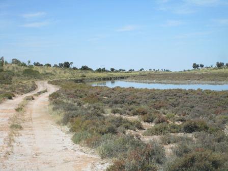
Around
the edge of another salt pan to Well 19.


Well 19 – Kunanaggi (13 feet, 4m)
This was the first well given an Aboriginal name by
Canning although other springs, Biella, Durba and Diebil had been given local
names. A steel wagon tyre is all that remains of a wagon abandoned by George
Williams in 1938. He had been attempting to take a load of stores from Wiluna
to Billiluna.
No
sign of the wagon tyre now – would have rusted away in all the salt. The water
is not very nice either – it is red. The old trough is still there in the
grass.
Went
for a walk across the salt pan as someone had recently driven across and by the
looks of it, got a bit stuck. They had another go and got across.


We
followed the track around the salt pan and over a sand ridge to the other side.
Saw their wheel tracks coming out of the salt pan.
The
sun is quite hot in the later afternoon. I ended up with one very dark arm on
that side compared to the right arm so I cut up one of the long sleeve shirts
Steve had to make two arm covers. Putting this one to good use at the moment.

Another
dead trailer – glad we didn’t bring on. Steve saw the toilet seat in the back
so set it up for anyone with an emergency!!


Back
on the road again – mainly doing 20 to 30kph. Crossed over some rolling sand
ridges so took a video to show the boys what it is like.

A
dead fuel tank this time beside a pushed over tree – wonder where the car is?


The
next ridge had a lot of whoopy-doos on the climb up so Steve had a look to see
if he could run up the side of it. Took a video of going up that one. He backed
off near the top as we were getting a good bump along in 2nd gear so
we backed up and then had another go in 1st gear high range and it
was all good.


Found
a nice resting place for yet another trailer. 2015 going by the dates left on
it from other travellers.


We
have noticed a lot of bigger ant hills around these wetter/salt pan areas.

Found
Savory Creek and it had water in it.
Savory Creek
Named by Canning in 1904 after Bob Savory, the leasee
of a station near Newman. Savory had supplied provisions for Canning’s survey
of the Rabbit Proof Fence.

Further
down was the crossing which was easy enough even though it appears a bit boggy
at first. Took a video of that too.


Continued
along the left side of the creek as it wound its way to Lake Disappointment.
The creek seems to get deeper as we continued along.


We
went as far as we could and parked up to have lunch. Nice view. It was 32
degrees in the shade with some wispy clouds coming over.
I
checked out the water quality – very, very salty.

Walked
around the corner a bit for a view over a very small section of the lake – not
sure if that is an island out there beside the creek – then around and back up
the creek.


After
lunch Steve checked under the truck for excess spinifex and usual routine
check.

We
continued along the track and as we crested a small rise we had another great
view over the area we were just at and I zoomed in to what seemed like an
endless horizon.


Back on the sandy track again for another 10km to another turn off back towards the edge of Lake Disappointment. It covers a huge area but I don’t know the actual size.


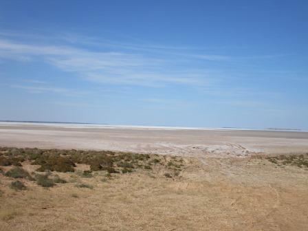


Lake Disappointment
This lake was named in 1897 by Frank Hann who, after following the direction of creeks in the area, expected to find a large freshwater lake.

Back
onto the CSR track for a bit then we turned off for a 10km (half hour) drive to
Well 20. We are travelling parallel with the sand ridges rather than crossing
over them now. Crossing and going around lots of salt pans.

Well 20 – Wangutju (18 feet, 5.5m)
Wells 19 to 25, with the exception of Well 24, are all
on the extreme western edge of the stock route. This is because stock feed was
very poor to the west and much better to the east of each of these wells. In
1955 Jack Gordon became very ill just before reaching Well 20 and was unable to
water his mob of 500 head. Almost half of the mob died of thirst before Jack
was well enough to draw water for the stock.


Luckily
we didn’t find any bones! Took some photos than the half hour drive back out to
the main track again.
Lots
of big anthills around here and they are all kinds of shapes.

Steve
(the tracker) had noticed we were following someone towing a big log – for
quite a while too. Eventually it went up the hill to a nice camp spot
overlooking another part of Lake Disappointment. Sadly they had left their log
smouldering so Steve got down the shovel and covered it in sand. We had a cuppa
overlooking the lake.


Continued
on around the lake and came to a sign – put in for the Bicentenary in 1988. It
is the last view for us of the lake before we climb over another sand ridge.

Passed
a few dry salt pans.

Ran
alongside one of the sand ridges till we crossed it then into the next flat
area to run along parallel with another ridge till we crossed it on a low
section. Lots of winding around sand ridges. Steve reckons if Canning had just
gone straight and up and down the ridges it would cut the trip in half!! He is
having ‘big climb’ withdrawals as we are just going over low parts. We can see
another range in the distance – probably McKay Range looking at my map.
Crossed
over a salt pan with lots of salt in the gutters left by others when they have
gotten bogged.

Spotted
a big gas bottle hiding in the bush – really!!

Nice
flat area around a salt pan – Steve gave the old girl a blast and got her up to
55kph in 4th gear – well for a minute or so!

Up
another ridge and over the top into a dip between the two ridges where we
spotted two bustards who didn’t fly away for a change so I managed a couple of
photos.


I
spotted some smoke to the west in the distance – shouldn’t worry us.

We came
to a Y intersection – track around the edge of a large salt pan or up the sand
ridge. Steve chose the ridge and we were the first ones on it this year. I
didn’t get a photo but took a video of it instead.
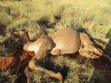
Running
alongside another ridge we spotted a dead camel right beside the road.
Obviously had only just been killed so Steve got out to take a couple of photos
of its hoofs etc. There were bare footprints around it so must have been killed
by some locals or the Rangers who are trying to eradicate them. They might be
feral but it is still sad. Steve said its foot pads are soft and the fur was
firm and coarse though softer at the top. We asked someone about how to make
better use of them but they said when they were rounding them up to sell to the
Arabs they would get a heap but the Arabs would only buy one or two which
didn’t make it viable. Apparently these ones don’t have the diseases the Arab
ones have to they just get a couple to use as breeding stock.


Back
into the gum trees rather than the desert oaks now as we near Well 21. There is
a big hole in the ground but you can see the well below and some of the timber
framing etc.


Well 21 (51 feet, 15.5m)
Water in this well was never of very good quality. The
direct track from Well 21 to 22 was built in 1988. Somewhere on the stock
route, possibly at a location like this, Wally Dowling fell and broke his leg
while trying to turn a mob of rushing cattle. Many of the cattle that rushed
were lost in the desert. Some considerable time later cattle from this mob were
found on Henbury Station near the Stuart Highway south of Alice Springs. They
were sold under the TA Doman brand in Adelaide. Stock are known to have walked
500 km, without water, along the sand dune corridors of the Simpson Desert but
this trek of over 800 km, without any physical feature to keep stock travelling
in a straight line, and also without any regular water sources, must rate as a
remarkable feat. (In good seasons stock are able to survive from the moisture
contained in succulent bushes such as the native parakeelya.)
The Death of Stephen Grace
In 1907, a party of four men known as the Kirkpatrick
Prospecting Party camped at Gunanya Spring, north of the present site of Well
21. During the night of August 24, they were attacked by Aborigines who speared
Grace in the chest and Kinkaid Phillips in the shoulder. Neither was badly
wounded. Robert and William Kirkpatrick doctored the two wounded men and the
party set out along the Rabbit Proof Fence towards Wiluna. Following Canning’s
survey map of the fence line they were able to find soaks and wells. However
one section of 110 miles (177 km) without water caused much hardship. Stephen
Grace became progressively weaker and although he eventually received some
medical care on the track south of Lake Nabberu, he died on October 10, 1907.
Further
along we came to a cross road for what appears to be a mine haul road. They
have come across the top of the ridge and laid clay base over it so it sets
hard so they can get their machinery in.


We
spotted a ute with a few locals in the distance so that is probably who killed
the camel.
All
this area was burnt and all the new growth is coming back but it leaves the
burnt branches hard when they whip down the side of the truck.


Further
along the flat we spotted about 15 camels so I told them to run to the hills!!
Took a video of them trotting along. I keep commenting that we haven’t seen any
kangaroos – maybe they aren’t in this area or have they all been hunted out!


Zipping
along the flats as the track is good at the moment – getting up to 35-40kph. It
is a bit corrugated so good to get up on top of them. A flock of budgies zoomed
by us – boy they go fast. Like all those little birds that like to dice with
death and fly in front of the truck.
The
sun is sinking into the west as we head around to Well 22. We noticed on the
map that the track goes north up to Georgia Bore which isn’t one of Cannings.
Well 23 is further to the east and the track I presume would have originally
gone that way but when Beadell put through the Talawana Track in 1963 they
might have change the direction of the CSR to use that road instead – will have
to investigate that.


Made
it to Well 22 through black sooty sand which coated the back of the track.
Again another hole in the ground but this time no water and only a bit of the
trough left in the grass.
Well 22 (53 feet, 16.2m)
This well was in ruins when Snell arrived in 1929. It
was also in ruins in 1954 when a party led by George Lanagan drove three 4WD
vehicles from Wiluna along station tracks to Talawana then across the desert
(before the Talawana Track was built) to Well 22. The well was completed dug
out and a circular galvanised corrugated iron liner put down about 11 metres to
the rock. This reconditioning was necessary so that Doman cattle could continue
to use the stock route. After their return to Wiluna, Miss Margaret Doman, who
was in charge of all the Doman properties, was contacted by Len Brown who was
bringing down a mob from Billiluna (pedal radios had been used on the stock
route for some time). Miss Doman drove George Lanagan and Dennis Booker to Well
22 to take the cattle on to Wiluna. Len Brown and an Aboriginal stockman
returned to Perth. Miss Doman is believed to be the only woman to drive across
the desert to Well 22 prior to the Talawana Track being built.


Someone
left their fuel drum by the track!

Lovely
after sunset colours.

A
sand ridge to one side with the two types of trees.

One
of the gums had fallen over so Steve chopped it up for firewood before we
headed off to find Georgia Bore. Unfortunately darkness has descended on us
again so the last 9kms is in the dark. Also the nice flat track has gone and we
are climbing in and out of what feels like a creek – or just the track all
eroded, so it was a slow trip in the camp area.

There
is a bore and toilet block and a few areas of cleared grass with fire pits to
camp in so we found a spot and set up. Too late for a camp photo – will do that
in the morning. No one else around again!! We have got set up down to a fine
art now and it wasn’t long before we settled down for a drink under the blanket
of stars. I can sit and stare at the stars for ages – trying to find satellites
as well – while Steve can just dream away looking at the fire.
Played
a few games of Skipbo and I had better mention that Steve won!! Steve got lots
of water from the bore (after he evicted the frogs) and we had long showers.
Map
of this section of our trip. I had forgotten to take a photo of the map for the
past sections which I had already uploaded so went back and added them in.

No comments:
Post a Comment