6.30am
17 degrees – much nicer. Clear sky. Lots of 28s, peewees chirping and a few
crows doing their usual moaning.
Simon
had left early in the morning as he wanted to get some photos with his drone
over the escarpment. The boys packed up to head south. We checked out the
information shelter. Interesting reading about the rangers – shame they don’t
do look after the area the traditional way though.


Good history about the Martu people.


Not
sure if the lovely grass here is Buffel Grass – if so no one seems to have done
much about it as it is growing very well here.


On
the other side was an aboriginal painting depicting this area of the Durba
Hills and the Springs.


Pat
came over to give Steve his phone number so we can detect there some time. He
devines for gold using one wire and Steve asked if he could show him as Erica
uses wires for gemstones. He explained that for gold as it is negative you
don’t need a wire as the wire in his right hand is positive. With water or
gemstones it is different. I asked if I could video him so I could show Erica
when we see them later. I will have to try it with Erica’s wires.
Durba Springs
The natural pound shape surrounding Durba Springs was an
ideal place for drovers to rest both cattle and men. Cattle would camp beside
the water while the drovers usually set their camp toward the entrance of the
pound thus keeping the cattle in check with little effort.
They
all left so we walked over to the ‘spring’ which is a pool in the creek. Water
isn’t much good but it makes for a nice photo.


Walked
over the dry end of the pool to where drovers have etched their names in the
walls during the early years. Of course some ‘others’ have carved their names
but the rangers and some volunteers have scratched them out.


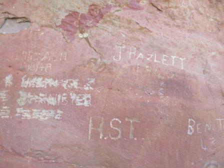


A
bit further round it looks like someone has etched “The Drovers Dream” but it
is hard to read.

Another
one further along is hard to make out but seems to be written by ‘Desert
Dogger’ (term used for Dingo hunter) and is written a lot later since it
mentions Japanese etc. Will get Dad to work on these photos to see if we can
read more of it.

Looking
back over the pool and the lush grass to the wall on the other side. It would
have been a perfect spot for the drover’s to camp at with the walls making a
fence for the cattle.

We
followed the creek down to the other side to look for aboriginal paintings the
boys mentioned over there.

Did
a pan around from one side of the ‘gorge’ over the campground and to the other
side where the creek goes to the pool.


I
had put shorts on today as it is a lot warmer – wrong idea as we had to work
our way through the bush and up to the side of the cliff face. Found a lovely
opening though with one little painting but with a great ‘window of nature’.


We
are up a bit higher which gives us a great view over the other ‘island’ hills
nearby.

Kept
crawling our way back along the edge looking for paintings. Steve found a
grinding stone like we saw in the picture in the information shelter.


A
big rock has slipped down making a tunnel we passed through. No paintings but
lots of wallaby poo.

Another
big overhang but no paintings, more scratchy legs for me (learnt that lesson).


Another
overhang and at last some paintings.


I
gave Steve the camera and headed back to wash my legs and put the kettle on.

He
kept working his way around and eventually found the paintings the boys had
mentioned. Lots of interesting ones –
would be good to know what they mean.


He
found a cave and went inside to lay down in case they painted something on the
roof but alas no.


Steve
came back and I looked at the photos rather than walk back there. The 28s were
having fun in the tree.


Steve
wanted to regrease a noisy bearing so I went for a walk further up the creek
from the campground. The boys had walked up that way and said they came to big
boulders which they had to climb over to get to a pool. It was a nice walk with
lots of lovely trees and big boulders etc to take photos of.


There
was another dry pool area then it got too scrubby for me to go through so I
headed back.


Looking
down over the campground from where I came out from the creek.

We
headed off and just drove out when two emus darted across in front of us. Back
along the track then back onto the CSR again.

I
spotted a hawk up in the tree onto of a sand ridge and he sat very still while
we stopped and took a couple of photos. Very nice of him.


My
notes said the sand ridges get bigger and harder with long winding ascents
which turned out to be true. I took some videos too so we can remember them.
The first one Steve went up in second gear and didn’t make it over – so glad I
got that on video. Second try of course he went up in first gear and did it
easy.

Lots
of poplar looking trees which I worked out to be young desert oaks.


Next
sand ridge was all good now he knows what to expect. Another video.

This
one was confusing but everyone was going to the right so up we went. When we
got over the other side we realised the left one was the ‘chicken run’ – glad
we didn’t take it!! Took a video of this one too.

Continued
up and down though we run alongside the ridges till they get lower so Steve
gets disappointed when we don’t go up a big one. We are passing lots of bushes
with little yellow blooms that flick off into the truck as we brush past them.


Turned
off the CSR track for a 20km trip out to Diebel Hills where there is a ‘spring
and two gorges’. We travelled parallel with a sand ridge for a long way – they
are long sand ridges!!

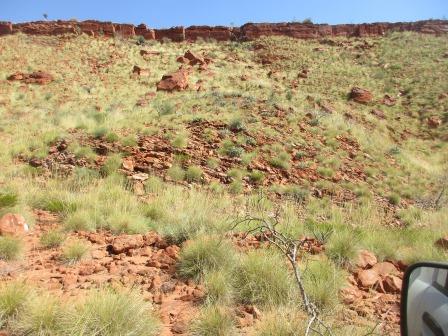
Then some rocky escarpments started to appear.

The Diebil Hills appeared.

On
the flat we saw some camels.


They
meandered slowly up the ridge and stood there giving me plenty of time to take
photos – not that I haven’t taken heaps already.

Continued
on closer to the hills.


We were following some recent wheel tracks which were probably the boys. They did say they went up a sandy creek. I took a video as we ploughed along.

We
had spotted some wheel tracks going up off and out of the creek but not quick
enough for us to turn up. The other tracks had kept going so we did too then
there was a tree across our path and Steve stopped. And that’s where we
stopped. Well this is why we bought some ‘Treds’, to get us out of these
predicaments. They worked but it took us a few goes forward till we could get
up and onto hard surface beside the creek. I got some of the burnt branches to
lay in the tracks etc as we have to go back the way we came in. As Steve says
while we are going it is all good, just don’t stop.


I
made some lunch and we enjoyed the view up the escarpment.


We
made it back ok then turned off up to where we saw the other tracks and
followed them along. On the Hema Navigator we are still on the same dotted line
but then we start to turn away from where we had gone up the creek. Continued
along the outside edge of the hills through sand then rocky sections but no
more dramas.


Certainly
overgrown here so the side of the truck is getting a whipping.


I
love the colourful blooms out here in the desert.

We
turned onto another track which went up into a gorge but nothing exciting to
see.


Continued
around the hills. Looks like this big slab fell from the underside of the hill.


We
got to the end of the road where the Hema says the Spring is. Nothing we can
see without a long walk through spinifex so took a photo then headed back.


Back
to the sandy creek section. We pulled some dead trees across our tracks so
others don’t make the same mistake and charge up there.

As
we headed back the 20km out to the CSR Steve got me to drive up one of the sand
ridges. And he videoed it. I am not that confident but decided to give it ago
but didn’t have enough revs and stalled at the top – forgot to put my foot on
the clutch!! Then I had to back down again and this time went into 1st
gear and more revs and made it up and over. He videoed that one too which was
good.
Back
onto the CSR crossing the sand ridges with long flat bits in between.


Stopped
to check out another dead trailer.

Turned
off the main track down to Well 18. It was reconstructed in 2016.
Well 18 (16 feet, 4.9m)
Well 18 was reconditioned by Snell in 1929 and was
again reconditioned in 2000 by a team led by Ken Maidment.


There
was a cairn nearby but we could see any timber marker so I added another rock.

Not
the most attractive camp spot but it will do us fine.


As
it was 4pm we decided to stop here the night and it has good water for showers.
It was a hot day but the breeze was good. Still 32 degrees on my thermometer –
in the shade.


Got
set up then had a drink in the shade. After lovely long hot showers we had
dinner then played a few games of Skipbo.
The map of this section of our trip.
The map of this section of our trip.

No comments:
Post a Comment