7am
-0.7 degrees – just a bit nippy. We are nice and snug in our bed.
Got
up at 8am and it had managed to get to 1.5 degrees. Steve got the fire going as
the sun is very slow warming us up today as there is a tree in the road.
9am
6.8 degrees. Packed up and headed off. We went through the pastoralist’s gate
to check out the rest of the waterhole. Found the old Pump Station. Couldn’t
find a door so maybe this was just the platform for the tank on top.

Nice
long waterhole. Drove a bit further along past some other campers for another
view of the waterhole.


Back
to the O Track and continued on. Passed the road crew’s vehicles, they have
been doing a good job as this section is as smooth as glass.

The
next section is no so good – giving the clothes in the ‘washing machine’ a good
tumble though.
Rolling
up and down ridges as we travel beside the rail line embankment. Checked out
North Peake ruins while we had a cuppa.


Crossed
dry Peake Creek then ran alongside a long sand ridge. The road crew had their
camp next to the ridge.

Saw
a cairn which was about William Ernest Giles.


More
sand ridges – we feel like we are back on the Canning but on a much better
road. Back into open country now with grass and an occasional low shrub. The
trees are only in the creek beds. Denison Range appears in the distance on our
left. Spotted a big water tank near Bungadilla Creek – lots of old sleepers
left here on the track.

Bungadilla Creek
This is about the southern limit for Gidgee trees
(Acacia cambagei) which become more common further north.
Further
along we checked out the ruins of Warrina Siding.

Warrina Siding
This was named by Mr Mann, engineer in charge of the
construction of the railway line. The cairn commemorates the Elder Scientific
Exploration Expedition which was organised and financed by Sir Thomas Elder.
Elder knew there was little chance of finding more pastoral country but was
interested in exploring the few remaining areas of desert in WA and SA. The
expedition, led by David Lindsay, was beset by many difficulties and finally
had to be recalled before completion of the proposed route. Although often
considered a failure, it was responsible for many important natural history
discoveries.
Across
the road is a cairn for the Elder Expedition and some old machinery from the
copper mine at Peake and this poor old wagon.


Hema
showed the track to the Peake Overland Telegraph Station from here but it now a
private road. We had to back track to the ‘PAR’ which was passed earlier but
didn’t realise what it was.

Up
and down rolling hills covered with white pebbles (probably quartz) with
ironstone outcrops here and there.


The
cattle look very healthy, though when you look what’s around it is hard to see
what they survive on.

Round
some hills and salt pans. Water in the wheel ruts where someone went down in
the soft stuff. Very salty too.

Pulled
over to check out the ruins of the Hammer & Gad Eating House (est 1870s).
Obviously the local ‘pub/restaurant’. Must have been a few people living around
here back then.


Water
leaking down the hillside from these clumps of reeds – artesian springs.


Very
salty ground.


Parked
beside some big palms and read the information board about the springs here.

Picked
up a brochure from a big metal box full of them. Very interesting site as there
are Mound Springs here, it was first a pastoral lease and a few buildings are
from that era, then more buildings were built when it was the Telegraph Station
and then they were used by the miners when the copper mine opened up near here.
Now of course it is protected and open to the public to learn more of our
history. There are a few walks to do. Good signage as we walked up the track.


Amazing photos – imagine dressing up like that to ride a camel.


The
Settlement Well – Steve tasted the water and it was brackish but not too bad.
Took a video of the area.


Peake Overland Telegraph
Station. Here the signal was relayed on to the next repeater station from 1872
to 1891. The northern wing is probably from pastoral times (1860s) and the
southern wing was constructed for OT operations in 1872. The lean-to rooms at
the rear were probably built for workers at the Copper Top mine and smelter in
1900.


To
the left is the Government cart shed and smithy (1872).

To
the right and heading slightly up hill is the Mess Hut, originally built for
the Peake Pastoral Station (1860s). Beside that was the Kitchen built for the
OTS (1872).


Beside
that was the Store – originally built for the pastoral station.

Then
the Main House which was also the pastoral station era. Amazing to think the
door frame is still intact.


Further
along is the Men’s Hut (OTL 1872). Must have been cosy in there.

Great
view.

Not
much remains of the Blacksmith shop of the pastoral era (1860s).

By
the amount of droppings around here there are plenty of rabbits about.

Walked
back down to the well – looking across to the sand ridge.

Back
to the truck to make some lunch. Unfortunately the flies found us. It is still
quite chilly so we sat in the sun trying to warm up.
Back
up the track to do the Mine Walk. Passed the ‘dunny’ or ‘privies’ as the sign
said – built 1872. Steve checked it out.


Walked
up the track following a valley to check out the Copper Top Mine Smelter
1900-04. At this time there was an
increasing demand for copper wire needed for the new technology of telegraph
and electricity lines. Unfortunately the ore was poor quality and not enough of
it to sustain the elaborate and expensive smelting works which were funded with
Victorian capital.


Eucalyptus coolabah.

The
Forge – not much remains.


Continued
on and climbed up to the slag heap.


Brick
foundations. The tiers allowed the
smelting process to progress down the steep slope, the ore being conveyed from
the nearby shafts on the ridge top. Remains of a wooden stairway. Fire bricks
for the smelter, stamped GARTCRAIG, were imported from Glasgow.


View
back to the OTL.


Up
to the next level where there is a bit of old machinery that was part of the
crushing process.


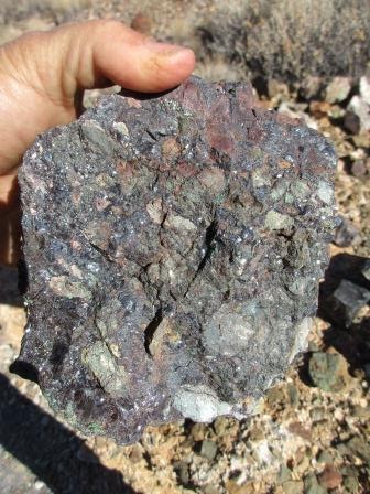
Lots
of rocks around with green colouring. We aren’t sure if that is the copper or
copper oxide after it was been exposed to oxygen – will have to look into that.
Other rocks have black shiny bits.


View
across to one of the shafts on the ridge further over.


Up
to the ‘sorting floor’ – still piles of rocks that weren’t processed.


Some old Coolibah logs that
were left behind when the mine was abandoned. Coke was railed to Warrina siding
to fuel the smelter, but there was also high demand for local wood for various
structural purposes and for firewood.

More
piles of rocks waiting to be sorted and crushed.

Looking
across the hills to Copper Top Hill that the mine was named after.


Spotted
another building down the hill – might have been for the pastoralist.

Not
sure what this pit was for.


Checked
out the first shaft. It has been lined with Oregon timber. Doesn’t look too
safe.


Around
to the next fenced shaft. It was faced with local Coolibah timber but that is
long gone.


A
few other shallow shafts are nearby and piles of dirt were they were exploring
for more ore.


Lovely
view over Mt Kingston that we came around.


‘Dead Finish Wattle’ (Acacia
tetragonophylla) grow in the middle of rocky outcrops. Cracks in the rocks
provide and ideal spot for the seeds to lodge and water run-off from the rocks
creates a microclimate promoting germination and growth.


Pastoral photo-point – This
small peg has a marked disc which is one of several thousand photo-points
established by the South Australia’s Pastoral Board to monitor land and
vegetation condition across the pastoral lands of the outback. Photographs are
repeated every few years to measure changes in condition due to grazing
pressure or seasonal conditions such as drought or rain.

View
back over the smelting plant.


Continued
along the track past another acacia. This track was the old bullock and donkey
dray track used to access the mine and smelt site.


At
the top of the ridge above the ruins – great view of Mt Kingston, the flats
where the Eating House ruins are then over the historical precinct. Took a
video of the view.


Easy
to spot where the springs are by the high reeds.

Back
down to the ruins – found a pile of broken ceramic insulators.

Down
to the truck then we continued on the other direction for the Creek and
Cemetery Walk.
The site of the Goat Yard.
Early European settlements in the outback rarely had access to dairy cows so
goats were a common alternative supply of milk. Because of dingo predation the
goats would be shepherded by day (usually by Aboriginal women and children) and
returned to a secure yard at night. The dark coloured mound here represents the
accumulated dung of one of these overnight goat folds.

Crossed
over one of the many little streams from the springs at the base of the hills.
Nice clear water.


Gidgee
(Acacia cambagei) tree.

We
are walking over pebbles but as soon as you break the surface it is powdery
dirt.

Continued
along till we spotted a few tombstones on a hill side. The powdery dirt is easy
for the rabbits to dig their warrens into. Have to watch we don’t collapse one
as we walk along.

Big
tombstone for George Rolland, died 14th July, 1887, aged 28. Smaller
one for Roderick Edginton, died 11th March, 1900, aged 33. Another
unmarked grave.


I
climbed up the hill to take a photo back across the historical precinct.

River Red Gum (Eucalyptus
camaldulensis) occur along creeks, rivers and drainage lines over much of
southern Australia. This northern form is more compact and drought-tolerant,
and is found along many inland drainage lines, sometimes in association with
Coolibah.

Riverine Wattles - A copse of Broughton Willow (Acacia salicina) occurs here, a long way north of its main South Australian distribuation on the Broughton River, near Crystal Brook. This drainage line feeds into Peake Creek, which in turn links with the Neales River, a major watercourse that flows into Lake Eyre North after good rains.

This modest flowing stream is the overflow tail from one of the mound springs nearby. Most mound springs have an overflow tail that usually peters out a short distance from the main spring outlet. These permanent spring overflows support sedges and rushes, in contrast to the creeks and rivers that flow only after heavy local rainfall.

We
followed the stream up to try and find the actual source but there were too
many reeds to get through. Back to the truck and headed back out. You can see
how the ground has built up over the centuries with the sediments from the
water and creating the ‘mound’ effect.

More info from a brochure about the Mound Springs and Great Artesian Basin.


21
km back to the Oodnadatta Track. Back past Warrina ruins and the track to Peake
Station Homestead. Running parallel with the railway. Another long bridge over
Edwards Creek.

Turned
off to the Edwards Creek siding (built 1889) & village ruins for a cuppa.
More buildings etc here. Walked to the furtherest one to take the photos.


During
Second World War time the facilities here were upgraded by the Commonwealth
Railways.
Steve
checked out the chimneys – all that’s left of those buildings. The rest has
been pushed up in a pile behind them.

Steve
was impressed with the Kennicott water softener (desalination). Looking inside.
Must have been pumps etc mounted on the concrete.


Further
down were the usual railway buildings we have seen but there were two of them.
A few rooms still have some of the ceiling. Sadly the vandals and graffiti
people have gotten to them. The backs were closed in on these ones.


Crossed
over dry Edwards Creek. Continued over flat gibber country with the occasional
sand ridge to roll over. Still very cool though it is nice in the sun if you
are out of the breeze.
Davenport
Range appears to our left – looks purple in the afternoon light. The railway
embankment had been on our left but now we cross it and continue with it on our
right.
An
old truck at the turn off to Nilpinna Station Homestead.


Duff
Creek siding has a great big sign but no buildings anymore.


Drove
down into Duff Creek – dry of course. Under the long bridge due to the wide
watercourse.


Through
the sand to park up for the night. Needed a tree to hang out the washing. Catch
a bit of the afternoon sun and it should dry overnight. The cold breeze has
stopped.


Our
route today.

The
temperature dropped quickly as the sun set. 8.30pm down to 8.4 degrees though
we still sit by the fire playing cards. Coffee at 9pm then into bed, down to
7.5 degrees.
No comments:
Post a Comment