7am
2.4 degrees, bit of cloud cover and cold breeze. The breeze turned into a cold
wind so a 7am it was 9 degrees but it only felt like 5. Living in our jumpers
and big coats.
Found
an interesting coloured rock.

Packed up and drove back up the creek and onto the O Track.

The
railway embankment is off a distance to the west of us. Next siding is
Boorthanna but there is no track to it.
Good
track still, up and down rolling hills with rocky outcrops. Crossed a few small
dry creeks. On the top of a rise you can see forever.
Back
to red sand ridges again.


Past
the turn off to Anna Creek Station homestead and Cooper Pedy then into William
Creek. Here’s a good spot for Jon to play golf – cheap too. Note on the Pink
Roadhouse map – Town is very busy when there is water in Lake Eyre, otherwise
the population is 12.


William Creek
This was named in November 1859 by John McDouall
Stuart during his explorations in this area. William was the second son of John
Chambers, a pioneer pastoralist in SA. The small township, built during the
railway construction of the 1880s had only a few cottages, school and a
hotel-store. Although its demise was almost guaranteed by the closure of the
Ghan Line, William Creek continues to defy all predictions by catering to an
increasing tourist trade.
Pulled
into the park opposite the hotel and made a cuppa. Checked the fuel price - $2
per litre for diesel here.

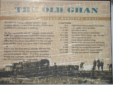
Ghan information and a couple of memorial plaques.


Only
Optus Mobile available throughout this area. There are a couple of Telstra
phone boxes. Obviously Telstra didn’t think there were enough people to provide
coverage around here. Interestingly they are beside a plaque about connection
the phone service here with Telecom in 1987.


Chatted
with a few people – very busy here. Heard a noise and looked down the road to
see a plane going across it. You can do scenic flights over Lake Eyre from
here.

Found
two information boards near the campground about Kidman who bought Anna Creek
Station which is the largest cattle station in the world. The other is about
William Creek etc. I have since found out that Gina Rinehart (2/3rd
share) has purchased S. Kidman & Co for $386.5 million in conjunction with
China’s Shanghai CRED (1/3rd share).
She already had cattle stations as well as her iron ore businesses. She
is now one of Australia’s top 5 beef producers and has a fortune of $16.7
billion. WOW


There
is an open air museum around the site of the old railway siding. An old steam
engine used to power water pumps.


An
original Oppenheimer pole which was used on the Overland Telegraph Line when
natural timber poles weren’t available. They were transported in sections on
camel back from Port Augusta.

We
are on the edge of the Woomera Rocket Range area (prohibited area on my map).


Unfortunately
the Black Arrow is missing. I found a photo online.


In
one corner of the park are memorial plaques for various locals.

We
went into the hotel for a look. Plenty of business cards decorating the main
bar.

Seems
to be the trend – make a donation to RFDS and leave your name somewhere on the
pub walls, ceiling, wherever. We did that at Broad Arrow Hotel in WA.


In
the dining room the walls are lined with sleepers from the narrow gauge Ghan
railway line.


They
are still using railway sleepers to keep patrons warm.

Maybe
we should have stayed for the sunset photos at the Painted Desert.

Steve
did his Crocodile Dundee impersonation.

Checked
on the road condition to Halligan Bay on Lake Eyre as we had seen that it was
closed when we were at Oodnadatta. All good as it has just been graded. As we
headed out another plane crossed the road!

Nice
smooth road as we head over the hills.


Stopped
to check out some of the old telegraph poles – the cypress pine one and the
metal Oppenheimer type .


Turned
off onto the Lake Eyre North Track. Checked out the map at the National Parks’
information board.

Lake Eyre/Kati Thanda
Lake Eyre was discovered by Edward John Eyre in 1840.
He believed it to be part of a great horseshoe lake barring any passage to the
north. In 1858 Babbage and Warburton found a way through the lakes and a year
later John McDouall Stuart started his series of explorations to cross the
continent. Little importance was placed upon Lake Eyre and no major exploration
was undertaken until the 1920s when Dr CT Madigan carried out a series of
ground and aerial surveys. His conclusions were that little if any water
reached the lake, and that it could never fill. Madigan’s statements were
proved wrong soon after his death when heavy rains in Queensland during 1949
and 1950 brought a massive flood down the Diamantina and Cooper river systems
resulting in the first major filling seen by white man.
The lake’s two sections are connected by a 13km long
Goyder Channel. The inland drainage basin is one of the largest in the world
and covers about one sixth of the Australian continent (1,300,000 sq km). Much
of this area is desert with an annual rainfall of 125 to 250mm.
Every few years some water flows into the lake but a
major flood in 1974 was estimated to be the largest for at least 500 years.
During a major flood the Diamantina, Georgina and the Cooper flowed for more
than 1,000 km and after many months eventually reached Lake Eyre. Huge flows of
water from the Macumba, Neales, Warriner and Margaret rivers flow into Lake
Eyre on a much more regular basis often covering a large area.
Lake Eyre (North)/Kati Thanda was site of the attempt
on the world land speed record by Donald Campbell in 1963 and a successful
record of 403.1 miles per hour (almost 650km/h) in 1964. The lake surface is
very treacherous near the edges but in the centre the salt is as much as five
metres thick and easily carried the heavy machinery needed to construct a
causeway and prepare the surface for the high-powered vehicle called the
Bluebird.
Continued
on, 57km to ABC Bay. We are driving parallel with a long sand ridge. Some old
fences/yards – for sheep?

Track
is good but you can see how boggy it was on the edge.

Caroline
Grossmueller was a Swiss traveller who perished here in the summer of 1998. Since
then 4 wheel drive rentals include an EPRIB. Found this information online
about her death.
On the 7th of December 1998 tourists Karl Goeschka
and Caroline Grossmueller (from Vienna, Austria) left William Creek Hotel to
travel 65 km East to Lake Eyre. Before leaving the hotel the couple signed
their name in a register letting the boy behind the counter know about their
whereabouts in case they would not be back within a few days so he could raise
the alarm. After arriving at the banks of the lake that evening they bogged
their Britz troopy campervan manoeuvring in loose sand at the camp site. Karl
did let the tires down a bit and dug some of the sand away with a plate but was
unable to get it free. They were stuck at the bush camping site, had a
full 65 litre water tank in the vehicle and enough food to survive for weeks.
They were bogged next to a shelter with large water tank containing over 300
litres of water. Karl and Caroline were confident that the hotel boy would
raise the alarm and that someone would come to their rescue. But after 2 days
of waiting at the banks of the dry lake, there was no sign of help. They became
worried that somehow they were forgotten.
Caroline and Karl decided that they could not wait any longer. They took a tent, various small articles, and 17 litres of water between them. As an experienced walker and medical student Caroline estimated they could do about 4-5 km an hour in the night, making it possible to do the 65km in less than 12-14 hours, just enough time before the heat of the day would become unbearable. However the temperature was over 40º each day (shade temperature) and did not drop much below 35º at night. They only walked 5 hours before needing to rest for another 5 having already drunk half their water. After another hours walking Caroline left Karl who felt he couldn’t continue, taking his boots because her shoes had started to melt and most of their remaining water and heading on alone about 4:00am on the 10th. Karl stayed in the tent during the day and returned to the lake that evening. Caroline only covered half the distance to William Creek and was found dead five days later by two German tourists. Caroline had died next to the road, half way between Lake Eyre and the Hotel. She managed to walk about 30 km before collapsing. She still carried almost 2 litres of water on her and had walked past cattle troughs and dams containing water (and was only 700m from another one when she died). Karl was rescued that same day.
During the inquiry into her death, the coroner attributed her death to "heat exhaustion and exposure".

A
mesa that needs one of those ‘do not drive on’ signs.

We
went over a rise and we amazed at the view in front of us. It was like a burnt
lunar landscape but it was some dark rock. Took a video of the view. We could
see Lake Eyre and it looked like water but of course that was a mirage.


Turned
onto the track to ABC Bay and the water just kept disappearing as we got
closer. No trees, no water and no shining blue sky – not very exciting. The
wind was still blowing and still very cold. Won’t be taking off our big coats
today. Hot soup and hot mince wraps for lunch today with a hot cup of tea.
Huddled in beside the truck out of the wind.


Back
out to the main track and 10 km on to Halligan Bay. The landscape changed again
back to sandy ridges and low shrubs. Spotted a dead fox beside the road and then
when we dropped down beside the lake we saw a dead dingo. A couple of Wedgies
flew up nearby so maybe there is something else dead over there.


Again
the ‘water’ disappeared as we got closer.

Drove
around the edge of the bay to the campground. Lots of bollards to mark out the
‘day use’ and ‘camping’ areas for the National Park. We were thinking about
camping here but with the wind blowing, no pretty scenery we decided we
wouldn’t – and no fires, though there is a big pile of ash in the campground.


Checked
out the info board – we will be 15m below sea level when we walk down to the
lake. Will check out Level Post Bay when we head around to that side. Nothing
about Donald Campbell here so it must be on the other side.


Headed
down to the lake – Steve spotted a little chap.

Selfie
time and a video of the view.

Steve
headed off to find some water!!

But
all we found was salt.


Here
we are at the lowest point in Australia.

We
did find water as we walked out further, rising up under our feet.

We
headed back before we got bogged. Dark clouds are coming over too.

Lots
of gypsum as we walked back up.


Headed
back out – Mr Wedgie had turned the dingo over. I got him in flight.

Saw
two wedge-tailed eagles and a nest in a tree (the only one around here).
Stopped
at the National Park info board and made a cuppa before we continued on.
Watched a chap slowly ride on his pushbike along the O Track heading to William
Creek – crazy.
Back
on the O Track and over Lake William – no water in it either.

Beside
the railway embankment again – the bridge is missing here.

Someone
has been writing on the Dip signs – like the ones going to Cape York. Skinny
Dip, Lucky Dip.

Across
the red Irrapatana Sandhills (average height 8m). The road was rebuilt in the
1980s atop the old railway line embankment.

An
old car, a pile of rubble. posts and a fireplace is all that’s left of
Irrapatana Siding.


Pulled
into the Strangways Siding ruins and found a place to park beside a shrub to
try and block some of the wind. The OTL station is across the road up on a
ridge.


Pulled
out the awning and wind shield in case the dark clouds develop into rain and to
try and keep that nasty cold wind off us. There is another van here but they
are inside – probably with their heater on – now I miss my van. Steve got some
firewood and old sleepers and got a nice fire going. The wind has settled thank
goodness.
Walked
around checking out the bits and pieces lying around. Steve thinks this would
have been the bore and the water would have been piped into dams here to cool.


The
rail line goes straight in both directions.


Rang
Mum and Dad on the satellite phone as we haven’t used it yet.
Today’s
route.

Had
dinner, played cards (wind barrier works well) and into bed by 10pm as it was
only 7 degrees and the wind has picked up again.
No comments:
Post a Comment