Anthony
would have been 27 today. How the years have flown.
8am
5 degrees, the sky is clear and blue again. The other campers were up and on
the road again early. Steve got the donkey going so I could have hot water to
wash my hair – lapping up this bit of luxury.
Packed
up then had a cuppa before hitting the road again. As we drove out we passed
the date palm plantation.

Didn’t
go far, only 6km down the road to check out The Bubbler and Blanche Cup mound
springs. Flat country then a few bumps appeared.


Water
everywhere as we headed in.


Drove
to the end of the track to check out the Bubbler first. A bit of information
and the Dreaming story of the area. Followed the long boardwalk around to the
top of the mound.


It
was quite mesmerising. The dirt under the clear water would bubble up but not
break the surface or make the water dirty as it moved around. Took a video of
it too. It really did look ‘alive’. I wonder how deep it is and whether there
is a solid bottom with just cracks in it. The bubbles would come up in
different places at different times – it was fascinating.


Looking
the other way it just looks desolate.

Occasionally
a bigger bubble would break the surface.


The
water then flows down and around the base of the mound and out onto the flat
creating a green grass area. It then continues around and back to where we
drove in.


Looking
back to Hamilton Hill, another extinct mound spring.


Drove
back along the track to Blanche Cup.
Signs could do with a refurbish.


Took
a video of the view and spotted some old fence posts from the sheep/goat times.

Noticed
a cairn on top of Hamilton Hill so zoomed in.


Back
to the Oodnadatta Track and on to Margaret siding for lunch. Lovely sitting in
the sunshine. Breeze is still chilly. Watched all the cars, vans and motorbikes
zoom by, no one stopping to check out the history. Such a shame but maybe they
have been here before. There is information here because it is in the
Conservation Area.


Steve
found a capped bore out the back. I wonder if someone took out the bolts or
they have been sitting there all this time.


Continued
on towards Marree – the ‘dip’ signs continue, Dippy Dog, Dip Stick.
Across
Margaret Creek which actually has some water in it.

We
then dropped down into the Stuart Creek floodplain – eaten away leaving ridges.
Curdimurka ruins in the distance. The water was red as we drove by.


Stuart Creek was named Chambers Creek by BH Babbage in 1858. Chambers Creek Station
was one of several taken up by Stuart for a syndicate headed by John Chambers.
The name was later changed to Stuart’s Creek, possibly because Stuart started
his many explorations into Central Australia from this point. Stuart was not a
rich man and didn’t put money into the land or stock. He usually initiated
leasing arrangements for others. Stuart Creek is one property that was in
Stuart’s name for several years and it is a fitting tribute that his name is
still perpetuated this way. The South Australian government resolved to grant
Stuart a pastoral lease of 500 square miles (24,000 square kilometres). Stuart
was to select and mark the site of his lease by January 1859 but there is no
record of him doing so. There is no evidence to suggest Stuart was given this
land by the SA government as is often claimed.
We
had to go a long way down then turn back up to Curdimurka. The railway line and
buildings have been kept fairly intact due to Balls being held here over the
years. Looking back along the track then as it disappeared towards Marree.


Curdimurka is an Aboriginal word referring to monsters which lived in the Lake
Eyre/Kati Thanda region. (Fossils of huge animals have been found to the east
in Lake Callabonna). The Central Australia Railway reached this point in 1886.
The Stuart Creek bridge to the west of Curdimurka Station is the second longest
bridge on the line.
Telegraph
pole or is a flag pole with the coat of arms below it.


Checked
out the building – doesn’t look like they have had any balls here in a while.


A
chap with his Mercedes Unimog was parked up making his home brew.

These
must have been the yards for the cattle waiting to be loaded on the train.

Walked
along and found an old cast iron stand pipe.

Very
salty dam.

Went
back to the truck then followed the track around the yards towards the bridge.
The old water tank and Kennicott type lime-soda water conditioner have seen
better days. The corellas like it though.


The
railway line is intact here. The eroded banks then fall away into the creek.


Lots
of gypsum here.

The
bridge is 433 metres long – impressive. No water in this section of the Stuart
Creek. The landscape was interesting so I took a video of it.


Walked
up to take a photo along the top of the bridge and the other side of the creek.


Zoomed
in on the other end – looks like it has fallen away.

Then
the corellas arrived.


BHP
1931. Nice and straight. The line had been welded together for about 60 metres.


As
we drove back out I noticed a line of white tyres for the air strip.

A
cairn to Stuart that we missed on the way in.

Back
onto the O Track. Lake Eyre South appeared – big and white with the mirage of
water in the distance. There was a pull off area so I thought this was the look
out – took a video of the view.

Then
we saw a sign pointing further on to the lookout. It is only 12 metres below
sea level here.
Old
railway line being reused as fencing.

Looks
just the same from this look out – white.


Lots
of information and photos.


Took
photos of the other things we will be seeing on our return trip in Sept/Oct.


Don’t
want to see this.

Our
little friend from Halligan Bay.

Will
have to come back one day when there is water in Lake Eyre.

Continued
on. The rail line is closer to the lake than the road. We spotted a drum closer
to the lake and a road leading to it so we drove down for a look. It was a bore
and there is another one closer to the lake near the rail embankment. There is
a and the water is piped underground for the
Olympic Dam mine at Roxby Downs where they have been mining uranium, copper,
gold and silver. On the Hema it shows another bore field to the east of Muloorina
station.


Left
the lake edge and we are back in sand ridges again.


Crossed
over the rail embankment so it is on our right again.

A
wall of dust is coming towards us. This is the first truck we have met on the
track and he obviously likes all the road.


Stopped
at Gregory Creek to check out another bridge which the corellas had moved onto.
They must like the warmth of the metal.
The bed of the Gregory beneath the bridge is at sea level. From here the creek falls another 13 metres to the bed of Lake Eyre (South)/Kati Thanda.


Spotted
the old telegraph poles down in the creek.


Chatted
with a chap from Czech Republic who had bought an old Landrover in Tasmania a
few years back and left it there. He saved some money so he could come back
travel some more. He likes his car so much he is planning to ship it home. Said
it will only cost him $4000. I said
about the cyclist heading to Czech and he said he had met them and hoped to
meet up with him in Alice Springs in July.
Passed
the turn off to Woomera on Bore Field Road. Spotted some more capped bores at
Bopeechee Creek. It is also another railway siding but we only spotted an old
sign, no ruins.

Bopeechee Bore
Field supplies a large quantity
of water to the mining complex at Roxby Downs. The bore field is on the south
side of a geological fault and lowering the water level is not expected to
affect springs further north. Round concrete structures beside the track
protect bore holes used to monitor water levels. A road beside the pipeline connects
the Oodnadatta Track to Roxby Downs Nothing remains of the Bopeechee Railway
Siding.
As
we got closer to Hermit Hill we noticed more salt pans and old mound springs.
The view in the other direction.
Hermit Hill
The Oodnadatta Track passes between the twin hills,
Pigeon Hill to the south and Hermit Hill to the north, from which Benjamin
Babbage in 1858 was able to confirm the existence of a path through what was
previously thought to be an unbroken chain of lakes blocking all progress
northwards. The ruins of old Finniss Springs Station is located on springs at
the northern foot of Hermit Hill. Interesting land formations can be seen from
the road and the only sulphur spring in the area trickles out through a culvert
in the old railway embankment.


Found
the sulphur spring in front of Pigeon Hill.


Next
railway siding was at Alberrie Creek. It is now privately owned by the Finniss
Springs people (originally an aboriginal mission) and there is an open air sculpture
gallery. Not sure what the old railway water tank is supposed to be.


Across
is another house with an interesting car feature.

Cross
Alberrie Creek then pulled up at the end of the sculpture park. Made a cuppa
then went for a walk through the art works. Obviously they weren’t happy with
the mining at Roxby Downs for uranium.


Followed
the rail way line down to Alberrie Creek.


Steve
went for a drive in the Ghan Hover-Bus. They must have had a lot of help to set
all this up on the old railway line embankment.


Looking
along the rail line to the old siding. Better angle of the water tank – I think
it is dog.


Pulled
into Poole Creek and drove under the bridge to find a camp for the night. Got
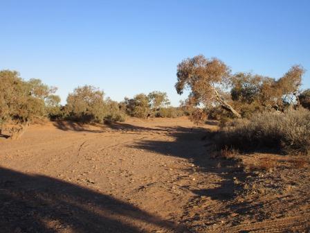
the washing out to dry in the sunshine while Steve went looking for firewood.

Nice
wide creek.

I
walked back to the bridge for the sun set photos. Found some old bolts on the
ground.


Climbed
up onto the embankment.


Looking
across to our camp spot.

Steve
came up the other side as the sun shone on the bridge.


Back
down and across the creek to the other side where the old Vermin Proof Fence
came to.
Vermin Proof Fence
Pastoralists followed the early explorers and by the
1880s hundreds of thousands of sheep were grazing the arid lands of SA, NSW and
Qld. Fencing was non-existent and mobs of 3,000 sheep were common. Shepherds
yarded sheep at night to reduce losses from dingoes. However, as the properties
became fenced and the shepherds phased out, losses from dingoes reached
alarming numbers. Each state developed its own policy. The Qld Government decided
to fence its southern and western boundaries because of rabbits migrating north
in the 1880s. Because of a dispute between the states the fence was built about
20m north of the border and the total cost borne by Qld. A vermin proof fence
policy was only implemented by the SA Government in the 1940s and by 1950 an
unbroken barrier had been built from Ceduna, across SA to the NSW border,
around part of NSW and through parts of Qld. At one time the Qld section went
as far north as Winton but in the past few years it has been considerably
shortened, reducing the commonly quoted length of 10,000 km to about 5,400 km.
The dingo fence is one of the longest man-made barriers in the world and can be
compared to the Great Wall of China which is estimated to be about 6,700 km in
length.


The
new fence follows the road instead of going down to the bridge.


Followed
it up to the double culvert then it continued across the road. This is the edge
of the Finniss Springs Rehabilitation area under the Arabana Aboriginal Corporation.
Across the culvert is Callana Station.


Back
at camp Steve showed me an old telegraph pole and some broken insulators he
found.


5pm
18 degrees, clear sky and lovely sunset glow. He has lots of firewood to keep
us warm tonight. We are camped beside a Coolibah tree.
Coolibah Tree
The rough grey-barked gum trees in Poole Creek to the
west of the Oodnadatta Track are Coolibahs. They are widespread in the north of
the state but are not found much further south.

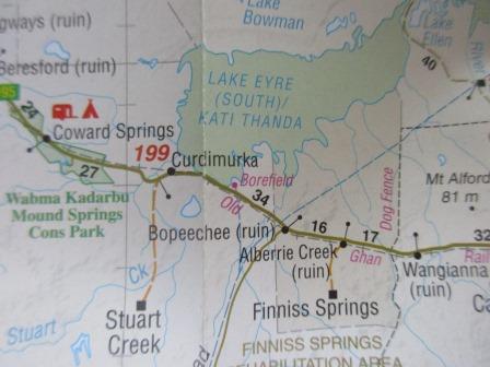
Our trek for today.
Only
spotted one satellite tonight but 4 planes went over us. Cool breeze. The
firewood makes good coals so we were nice and warm while we played cards.
No comments:
Post a Comment