Colder
night, 14.7 degrees at 8am. Leanne & Rick rang from Sydney. They will be
boarding their cruise ship around lunch time. They were heading to Noumea etc
so hope it will be ok since Cyclone Pam is still floating around that area
after wiping out Vanuatu.
Decided
to head into Launceston to do the gas exchange, fuel etc and visit Cataract
Gorge.
As
we head through Springfield (amazing there isn’t a big Homer Simpson here) we
stopped to check out another chainsaw carving. No info sign about it but it
must represent the pioneers of this area.
.JPG)
.JPG)
Overcast
morning with clouds heavy on the mountains. The view from Sideling Lookout
though was still good even though it was hazy.
Looking
up at Mount Barrow.

Decided
to go up to check it out, hoping the clouds will lift by the time we get there.
At 1,413 metres Mount Barrow is one of the tallest of the mountains that form
the northeast highlands. It is close to Launceston so is popular with hikers,
rock-climbers and hang-gliding. The Mount Barrow State Reserve covers an area
of 459 ha and was proclaimed in 1940. Due to its height and proximity to
Launceston it is an important site for communication towers and facilities vital
for public safety which belong to the Dept of Civil Aviation and the Ambulance
Service.
A
resistant cap of dolerite formed about 200 million years ago is responsible for
the spectacular mountain landscape. It has been sculptured over the years by ice
which also produces the freeze-thaw conditions necessary for the development of
scree slopes which we saw as we headed up the narrow road (910m).

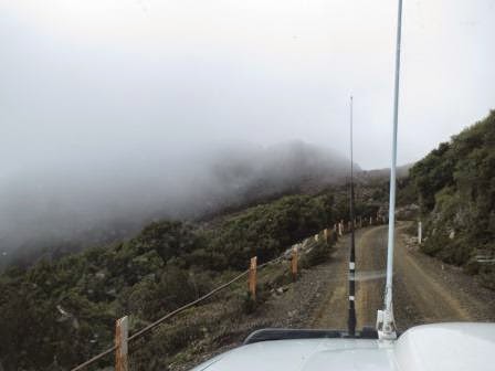
A
bit unnerving having such big boulders just sitting above us as we wind our way
up (1150m).
.JPG)
.JPG)
Looking
up to the road as it turns back again in the zig zag climb.
.JPG)
.JPG)
I
wasn’t too keen on the view straight over the edge!! A lot like the range at
Queenstown – I much prefer trees to cover up the view of the sharp drop below,
but I trust Steve’s driving.
.JPG)
Though
without any trees there are spectacular views. We will have to come back again
when it is a clear day.
.JPG)
The
clouds are moving quickly so it will be very windy up top. Should have brought
more clothes!!

As
the clouds clear we can see the top again.

Then
over they come again.
At
1300m looking at the top.

At
last at the top, bit open area with a cairn in the middle but no plaque.

Great view across to Ben Lomond National Park area with its mountains soaring up to 1500 metres before the clouds came across again.
.JPG)
The
Summit walk leads from the DCA radar station up a bitumen track to the flying
fox. Then a stone pathway and steps up to the DCA tower and from there you
follow the signs across the boulders to the summit which is marked by a trig
station - will do that next time.

.JPG)

Walked
out to the stone emergency shelter and peered down over the road we came up.

.JPG)
.JPG)
We
jumped back into the truck to warm up. Steve saw something appear in the cloud.
.JPG)
.JPG)
It
was another tower – we waited for the clouds to pass over and there were two
towers.
.JPG)
.JPG)
.JPG)
.JPG)
As
we left the clouds covered up the DCA tower again.

Heading
slowly back down the road, we saw a car coming up so found a wider bit to pull
over to let him pass. Looking down on a dam and forestry plantations way below.
.JPG)
.JPG)
More
shots of the road, rocks etc as we head down.
.JPG)
.JPG)
.JPG)
.JPG)
Stopped
at the Reserve’s picnic area (920m) to have a cuppa. There was a little nature
trail to follow with some plant information.
.JPG)
.JPG)
Haven’t
seen this one before. These are the trees we were walking through at Ralphs
Falls.
.JPG)
.JPG)
The
little creek coming out of the ground.
.JPG)
.JPG)
As
we head back to the main road we look across to Mt Arthur (1187m).

Sent a text to Sandra for her birthday today. Back on the main road we turned off at Nunamura to check out the Mt Barrow Discovery Trail, Forestry Dept. Passed the well signed entrance and drove the 2km up a forestry dirt road to the ‘STOP for Info’ sign but there was no information anywhere. Should have upgraded the sign to see ‘no info ahead’!!
Sent a text to Sandra for her birthday today. Back on the main road we turned off at Nunamura to check out the Mt Barrow Discovery Trail, Forestry Dept. Passed the well signed entrance and drove the 2km up a forestry dirt road to the ‘STOP for Info’ sign but there was no information anywhere. Should have upgraded the sign to see ‘no info ahead’!!
.JPG)
.JPG)
Great
view over Launceston as we head into Newstead where we had seen the Coles
Express. They still have the extra 10c off discount if we spent $20 so we
exchanged our gas bottle and got the discount on top of the 4c voucher. Makes a
difference when we have an empty fuel tank.
Drove
through town to Cataract Gorge, though ‘girlie’ didn’t quite get her
instructions right and we headed up north. Eventually found the main carpark.
Made some lunch. Steve spotted some owls in the tree branch. One woke up so I
got some great photos and then lots of people stopped to have a look too.
.JPG)
.JPG)
Walked
down to the entrance where the Basin Chairlift departs from. It is the longest
single chairlift span in the world, total length 457m, centre span 308m. It was
a official carrier of the Year 2000 Olympic Flame.
.JPG)
.JPG)
Lovely
old Elm tree planted by William and Sarah Bowen to commemorate the birth of
their triplet daughters, Sarah Faith, Louisa Hope and Grace Charity in 1905.
What lovely names.

Lots
of peacocks wandering around.
.JPG)
.JPG)
We
decided to walk over the suspension bridge and to do the walk down to Kings
Bridge and back.

Great
view back over the pool and picnic area.

Looking
towards the suspension bridge.
.JPG)
.JPG)
The
section of water is called the First Basin which is part of the South Esk
River.

Steve
spotted some ‘native’ art – hand prints on the rocks.

Steve
checked out the suspension bridge’s supports before he will go on it.

Great
view up the gorge.

It
wasn’t as bad as the Montezuma one but it still wobbled. He thought it had to
be safe since thousands walk over it every day.

Looking
back over the pool and chairlift area. The house up the top would have a great
view.

Across
the other side where the river travels down the gorge to join the North Esk
River to become the Tamar.

Alexandra
Bridge was opened by Lady Edeline Strickland, 29th Nov, 1904.

Further
along we climbed up some steps to a lookout above the bridge. Interesting
information and photos.
.JPG)
.JPG)
.JPG)
.JPG)
Looking
down on the bridge and the weir.

Another
view over the basin.

On
the other side there is a walking track that follows the river upstream to the
site of the Duck Reach power station. We will do that one another day.

Very
dry plants here, like these casuarinas.

Back
on the track around the Basin. Nice hut with concrete posts that look like
trees.

On
the other side is the Gorge Restaurant.

More
peacocks wandering around the lovely garden.


Looking
down the gorge from the restaurant’s deck area.
.JPG)
.JPG)
Lots of very big old trees. This one had this plaque below it.
.JPG)
.JPG)
.JPG)
Mummy
and bubby peacock.
.JPG)
As
we head down the Cataract Gorge walk following the river downstream, one last
view of over the Basin to the pool area.

Another
info board.

This
photo was taken of the First Basin in 1880.

Looking
down the Gorge and the walkways which were installed in the 1890s when the area
was developed into a resort for the citizens of Launceston, in true Victorian
style.
.JPG)
.JPG)
Split
Rock.

Not
sure about how they supported the walk platforms.

Great views.


Big boil holes where the smaller rocks are tumbled around in a hollow.

Below
some big tall rocks which we think they do rock climbing on. At the base was
some ‘art’ called Sounding Silence by Richard Tipping 1998 on Ben Lomond
granite. ???


Looking
upstream then downstream.

.JPG)
Zoomed
in on the bridge in the distance.
.JPG)
Big
crack in the wall on the other side, with a cave at the top.
.JPG)
.JPG)
Lovely
old Kings Bridge, built in 1863.
.JPG)
.JPG)
.JPG)
The
old entrance ‘Toll
House’ to the Gorge.


Looking
back up the Gorge.

Crossed
over the bridge to Penny Royal World which has a variety of historical exhibits from the 19th
century but I think it is undergoing a makeover.

Unfortunately
we didn’t find out about the walks and now we find out the Zig Zag walk goes up
and over the top of the hill on the other side of the Gorge. Oh well, what’s a
few more stairs.
.JPG)
And
a few more.
.JPG)
Climbing
up high – zoomed in on the walkers on the other side. You can hardly see them.
.JPG)
.JPG)
Some
more stairs, made back in the 1890s and they must have had long legs as the gap
between steps was quite wide.

Looking
down to the old entrance and
the old caretaker’s cottage.

The
South Esk River meets the North Esk River and become the Tamar.
.JPG)
.JPG)
Zoomed
in on the clock tower again.

The
Cataract Walk on the other side.

We
reach to top and look back over the Tamar as it heads north to the Bass Strait.

Phew,
down we go. Got a sweat up so off with the jumpers.

Looking
upstream over the First Basin and the top part of the Gorge.
.JPG)
.JPG)
Walked
out onto a platform for this great shot up the Gorge, over the First Basin and
the Suspension Bridge then further up the Gorge.
.JPG)
.JPG)
Steve
spotted a couple below us getting ready for a swim or something!!
.JPG)
.JPG)
The
Cataract walk was much easier than the Zig Zag one!!

Nearly
down.

Looking
over the pool area.

Walked
down to the water’s edge and across the causeway, looking across to the suspension
bridge.

The
water going downstream.

The
swans and ducks paddle quickly to keep them from going downstream.
.JPG)
.JPG)
.JPG)
The
water flowing downstream with the chairlift going overhead.

We
wandered back up the other side to find ‘Fairy Dell’ and another lookout. There
was a wedding about to start. Information in the rotunda where the guests were
gathering. We will come back again as we have to do the Duck Reach walk still
and it is starting to rain. Poor things, what a shame.

Back
across the suspension bridge and we saw someone having a swim. He called out to
ask the time. We said he must be from the North Pole – he laughed as he said he
was from just south of there.

Uphill
walk to the carpark on tired legs. Made a cuppa and chatted with a couple from
Bundaberg. Steve found another bird to feed.
.JPG)
Mick
rang after I texted him to see how is mum was. We are going to meet up on
Monday and try prospecting at Lefroy where the fire went through the State
Forest.
I
decided to navigate home rather than use ‘girlie’, unfortunately my way went
straight up steep hills with give ways at the top and it is raining more. Glad
we didn’t have the van on.

Back
over the Sideling Range through the clouds.

Lots
of vans and motorhomes in the park again. We watched the end of Qualifying for
the Grand Prix in Melbourne. I put some photos on Facebook and Lou messaged to
say he has to go to Lizard Island and rescue one of his marques that got
damaged from the cyclone.
The
rain stopped about 9pm. 20 degrees.
No comments:
Post a Comment