23
degrees at 8am with puffy clouds in the blue sky. Waved bye to Dave and Lauris.
Packed up then chatted with Wayne and Diane as they were heading off up the
Murray.
Headed
down the east side of the river – great view over the land from the crest of a
hill. The river is over on the right as it does a big turn.


Another
big bend in the river and cliffs near Burdett.

Into
Murray Bridge, great view over the rail and road bridges across the flood
plains and the Murray River.


Curved
bridge and very narrow.


Stopped
at the Info Centre and stocked up on maps etc. Down to the river at Sturt
Reserve for a cuppa with our friends.

Further
along was the Bunyip. Didn’t bring $1 to put in the machine to make the bunyip
come out of the water!!


Great
view up the river to the bridges and then downstream. Nearly to the end of our
trip.


Back
across the first bridge over the Murray River, 1879.

Into
the showgrounds where there is a RV area ($5 per night unpowered). No more
camping on the river’s edge.

Getting
warmer, 33 degrees today. Had some lunch and headed off to explore with our
walk/drive trail maps. Murray Bridge Speedway is below the showgrounds – Steve
raced there in his Formula 500 many years ago. The bridge was the largest steel
structure in Australia in 1879. It measures 1,980 feet in length. The original
arches have been replaced with higher ones because of damage by heavy vehicle
traffic. The railway used it too for 40 years. There were tollgates at each end
to stop other traffic, which were mainly horses and carts in those day. A new
rail bridge was built in 1925 after Murray Bridge township was gazetted in
1924.


Over
the bridge and through town to Swanport Road then onto the A1. Across the
Swanport Bridge. It was on the drive so I thought it was a ‘special’ bridge.


Drove
up to Frank Jackman Lookout – not very nice with lots of graffiti and rubbish.
Views over the river and bridge.


Down
to Long Island Marina and caravan park – thought we could check out the boats
but it is a closed access. Long Island is a long island in the middle of the
Murray.

Passed
the Anglican Cathedral of St John the Baptist, recognised as the smallest
cathedral in the world.

Over
the railway line to Melbourne laid in 1885.

Rocky
Gully Wetlands.

Parked
near the railway station and walked over the tunnel which was completed in 1923
which takes the trains down to the new railway bridge. Turned left over a small
bridge which is over the old cutting where the trains previously ran between
1886 and 1925 to cross the first bridge (which we drove on). Short walk up to
the ‘Roundhouse’ which was built in 1874 for the Overseer of the bridge works. It
was the first stone building in the area. Not looking to round from here.


Walked
around to check it out and the views over the river and the bridge.


Down
through the lovely garden. Sort of looks round from here.


Walked
down the hillside to the river’s edge and the old railway lines which went
around to the wharf. During 1910 over 35,000 tons of freight was trans-shipped
across the wharf between railway and boats. On occasion freight transfer
resulted in 16 trams leaving Murray Bridge in the one day. The 1956 flood level
is marked on the railway bridge.


Along
the walk are signs stating the names of the 29 paddle-steamers and barges
wrecked and sunken along here.

The
old Pumphouse, 1897, from where the town water supply was pumped until 1960.

Railway
yards and the 1886 wharf. Now the paddleboat “Proud” calls it home. Originally
it was called the Port of Mobilong and was declared in July 1886. It became one
of the three largest ports in the Murray Darling Basin along with Morgan and
Echuca, leading to the demise of Mannum and Goolwa as major river ports. The
total length of the 2 level timber wharf was 620 feet along with a further 450
feet of sheet piling face to the bank at deck level totalling over 1070 feet,
all serviced by two railway lines along the entire length. More than 6 cranes
were used at the wharf for the transfer of freight. Around 1919 to 1940 milk
boats were used from the dairies for delivery to the milk factory which was
just downstream from the wharf, a use believed to be unique to Murray Bridge.
The depth of the river varies from 25 feet to 60 feet.


Back
up the hillside through beautiful scented roses.


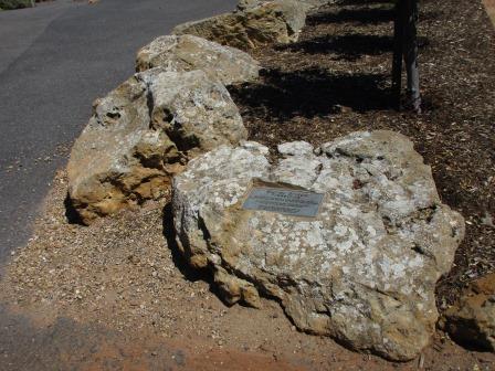
Murray
Bridge freestone – quarried on the eastern side of the river along the cliff
face and the Sunnyside Quarry from the 1880s. Due to weathering these retaining
stones display a honeycomb appearance.
Swanport
Granite – quarried at Sturt Reserve and alongside the Swanport Bridge.

The
Bridgeport Hotel was built in 1884.

Back
to the truck and back to the van for a cuppa. Chatted with some of the other
campers.
Rang
Erica for a chat. She has hurt her back but is feeling a bit better.
Warm night which was nice.
No comments:
Post a Comment