7am
21 degrees, sun out but dark clouds looming over Murray Bridge. Jumpers on as
it is only going to get to 25 today and the wind is still strong and biting.
Grabbed
by bottle with our water and rock from the source of the Murray River. The SA
Information booklets have great maps.


Headed
down the Princes Highway to Tailem Bend. In the 19th century Tailem
Bend was an important railway town. Stopped at the railway station to check out
the museum.


Lots
of photos and information.


Steve
changing the lines in the Signal Station.


Great
collection of old phones – remember the first mobiles phones!!


Outside
Miss Piggy was mowing the lawn.

In
the park was an old locomotive used from 1913 to 1965.


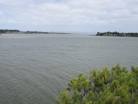
Over
to the cliff top heading down to the ferry. Great view over the Murray to the river
flats and Jervois (another wineglass reservoir).


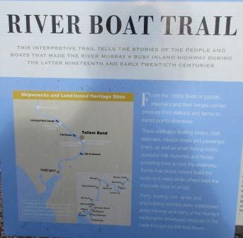
The
sun came out when I wanted to photograph the sign, hence the side angle. Lots
of ‘milk boats’ were on the Murray because of all the dairy farms in the area.


View
upstream, over the ferry crossing.

Down
to the ferry but turned left and went down to the old ferry landing
(constructed in 1924, last Government timber one built and used till 1960s) and
had a cuppa.

Lined
up for the ferry but had to wait while the ferry operator banged his sledge
hammer on the metal to scare the hundreds of corellas out of the trees next to
the ferry. They didn’t go far – across the river to the tree on the other
side!!


The
corellas are stripping all the trees.

Through
Jervois and passed lots of small dairy farms – smelly!! The paddocks have a
levee bank around them.

Into
Wellington where another ferry operates. The old court house and police
station. Wellington was settled in 1846 and was the only point where travellers
could cross the river for many years.


We
headed west away from the river and around the top of Lake Alexandrina which
the Murray flows into as it heads to the mouth. Turned off that road and headed
south till we ran into the Lake Alexandrina (649 square kilometres). It was
named after Princess Alexandrina, niece and successor of King William IV of
Great Britain. We are now at sea level. Point Sturt and Point McLeay in the
distance. Very choppy today.

Around
the edge of the Lake to Milang passed lots of wineries. Crossed over the Bremer
then Angas Rivers which also flow into Lake Alexandrina adding to the Murray
waters. Milang was the largest inland port in South Australia in the late 19th
century and a major transport hub for Melbourne. Stopped at a park where
Landseer’s boat building sheds and dry docks was operating in from 1860 to 1900.
He also had the big wool shed in Morgan where the Museum is now located.


Walked
out onto the old jetty (built in 1856) – the guys had caught a couple of carp.
The wind feels like it is from Antarctica!! The jetty had been extended a few
times due to low water, but shortened in 1958. The hand crane was placed on the
jetty in 1872.

Lots
of fishing shacks line the foreshore.


Back
in the park was a plaque about the P.S. Etona that was a church boat.

Another
plaque about Captain Sturt and one about the ‘Source to Sea’ riverboat voyage
in 2001 that I watched at the Museum in Mannum.


Through
the little township to the historic railway station, unfortunately only open on
Sundays by the volunteers who have put a lot of work into restoring the site
and displays. Original terminus Sandergrove – Milang Railway, 17 Dec 1884 to 17
June 1970.


Continued
along the Lake’s edge passed Olive groves, vineyards and alpacas to Clayton
Bay. Nice holiday area.

Drove
around to the jetty and found the info board.

I
walked up to the top of the cliff for a look.


North-west
up through the narrow area to where the Finniss River flows in (to right) and
where the Murray goes around Hindmarsh Island (to left) and heads to the mouth.

Looking
across to Hindmarsh Island then down south-east past Goose & Goat Islands
to Rat Island.


View
from the jetty to the cliff.

Back
on the road heading up along the edge of the estuary to across the Finniss
River (not very big and full of reeds) to stop for a photo of a canoe tree.
When we came down to the mouth in 2008 with Margaret & Gary, we stopped and
took a photo of one. Looking back at the old photos it was the next one we
stopped at.


Into
Goolwa and around to the Information Centre in the old Post Office. Checked on
low tide – it was at 11.30am, now 12.30pm. Found a couple of info boards too.


Drove
down to Goolwa Beach where the surfers were making the most of the strong wind.
We ate our lunch in the truck as it was too cold to be out!! The surf clubhouse
had a nice mural.


A
few groups came up from the beach with their buckets of Pipis (cockles). Gary
took Jon and Hayden cockling when we came down – found those photos – the boys
froze in the water.


Maps
of the area.


Steve
let air out of the tyres and put it in 4WD and off we headed down to Goolwa Beach.


All
good as we zoomed along Sir Richard Peninsula. The wind was blowing the sea
water further up the beach.


Nearly
to the mouth and we had to detour around an excavator that was moving the sand
being pumped out of the mouth.


Steve
let out some more air!! Looking back to where we came up off the beach.


Back
down onto the beach and the waves are rolling into the mouth at Pullen Spit.

Pulled
up in the middle with the sand dredge on one side and the ocean on the other.


Two
NZ fur seals swam by heading out to sea – the Info Centre lady said they were
at the Barrage.


Got
out my water from the source and tipped it into the mouth – well as close as I
could get as the waves kept coming in to get us!!


Decided
to keep some and the rock and add a rock and some shells from the mouth to it.


Steve
will have to wash the truck again – he only did it yesterday!!


Turned
into a lovely day though the wind is freezing. We
made it – has been a wonderful trip. Sad that it is over but looking forward to
the next adventure.


Steve
was freezing back in 2008 too.

Headed
back – some crazy fishermen.

The
birds like sitting in the vehicle tracks.

Passed
a few more vehicles heading down the beach.

Back
to the track entrance. Drove down to the servo to pump the tyres back up.


Back
along the foreshore – nice tree carving done by a couple of local council
workers, voluntarily taking 120 hours in 2015.


Down
to the Goolwa Barrage and Lock - long one.


Through
the pine trees and passed the workers houses to the info shelter.


Bit
hard to photograph with the glare.


Through
the gate and onto the Goolwa Barrage.


Lots
of black swans.

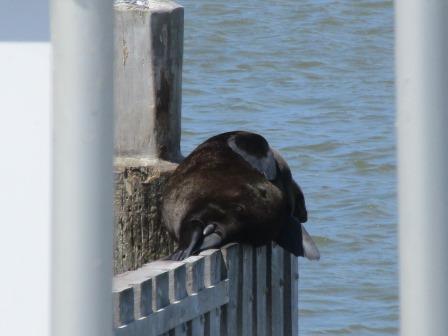
At
the lock we spotted a fur seal just heading into the water on the other side of
the lock. Others were snoozing away on the ledges on the other side.


Lock
users notice and another about the dredging.


Upstream
– Murray fresh water and downstream – Southern Ocean salt water.


Another
seal was perched on the edge of the lock and was wiggling around, either having
a nightmare or scratching his back. Took a video as I thought he might fall
off.


Lots
of Murray water seeping out into the saltwater.


Watched
the pelican and the silver gull catching fish.


Across
the lock is half of the turntable. Long way across – no access for us but
plenty of room for the birds.


Looking
back on Mr Seal – still snoozing.


Engineering
plaque.

Some
of the stop gates – lots of barnacles etc on the seaward side.


Lovely
little flowers.


Further
along towards to the mouth was a boat ramp. Sign about the sand pumping
project. Interesting Quick Facts.


The
Coorong National Park starts on the saltwater side of the barrage and runs for
miles along the coast of the Younghusband Peninsula.

Back
to Goolwa along the edge of the ‘Murray’ to cross over the bridge onto
Hindmarsh Island.

Top
view upstream and downstream to the pine trees near the barrage.


The
main street of Goolwa is Cadell and on Hindmarsh Island it is Randell – the two
Murray river captains. We have seen so many different types of ‘poo’ for sale
but this takes the cake!!

Turned
south to Sugars Beach to look across to the Murray Mouth and the dredge.


Another
board about the dredging. Great photo of the Murray Mouth when it had closed in
1981 and open again.


A
cruise boat heads out to the mouth – I think this is what Erica and Terry went
on last year.


Scanning
from the barrage side across the mouth to The Coorong.


Someone
has a great spot for a weekender straight across from the mouth.

Two
more info boards.


Back
to the main road and down to a huge monument to Captain Sturt and his men,
erected in 1930 on the highest point of the island.


View
across the Goolwa Channel to the Southern Ocean.

Back
up the Channel to the Goolwa Barrage.

Then
the other direction over Hindmarsh Island and the River Murray.


Drove
around to the north-eastern end of the island where there are heaps of holiday
homes and little channels to moor their boats in.

Back
to the main road – one side cattle and the other the entrance to a big marina
estate.


Had
a drive around checking out how the poor people live!!


Stopped
at the Hindmarsh Island Info shelter. The island is approximately 15km long and
6km wide. It is unique as it faces fresh water on one side and salt water on
the other. Named after the first South Australian Governor, Captain John
Hindmarsh, the island has been utilised for agricultural and pastoral
activities since the 1840s when it was first leased as grazing land. The first
Shropshire sheep stud (1852) and the first Hereford cattle (1868) were
introduced to Australia here. A ferry for public use was in operation from
1858. Initially a dingy then a council operated unit from 1862.


Back
across the bridge.

Looking
down on the wharf and rail area.


Stopped
to check out another couple of history boards.


Down
to the wharf and railway area. The tree was planted to commemorate the
achievement of Tammy Van Wisse in swimming the length of the River Murray
arriving at Goolwa on Sunday, 18th February, 2001.


The
paddle-steamer Oscar W was built in 1908.


The
wreck of P.S. Renmark is near the wharf.

The
Barge Dart was built near here in 1912.


Great
treehouse playground and comfy chair.


This
must be the last of the River Boat Trail boards.


Great
aerial photo of Goolwa to Murray Mouth in August 2002.

Back
to the railway station which was originally further in town. There are a few
tourist train rides from here, like the Cockle Train.


A few older buildings.


Headed
home. Through Currency Creek – lovely old building.

Turned
off near the canoe tree to short cut near Finniss to Milang, missing the big
loop down to Clayton Bay. Back up to the main road and turned north near Boggy
Lake to short cut back to Murray Bridge rather than going up through Wellington
and Tailem Bend. Saw some Cape Barren geese in the paddock.
Further
along passed the Australian Saltworks.

Ended
up a lovely day with clear blue skies but the wind was strong and cold. A few
more people have arrived.
Van
closed up to keep out the cold wind!!
No comments:
Post a Comment