Sunnier
morning. Wind from the north so the sea should be calmer today. Leanne &
Rick rang from Broken Hill. Helped Gary and Margaret clean and pack up for
their drive back to Adelaide. It was so nice to have a few days with them. Will
catch up again before heading off to WA.
A
lot hotter today. After lunch we headed off towards Edithburgh along the scenic
route on the edge of the foot to the heel. Love the maps they have for each
area.


First
stop was Meehan Hill Lookout.

Walked
further along and we are looking back over Marion Bay.


Down
the other side of the point was a great beach.

Along
the road to Hillock Point property. They allow people to drive down to the beach
and camp but it was closed when we pulled up so we kept on with our
sightseeing.
Next
was Kangaroo Island Lookout – which of course was just looking across
Investigator Strait to Kangaroo Island – bit hazy but could just make it out in
the distance.

Continued
on to Foul Bay. There is a Council camp area here but it is well back from the
beach. Found a sign about our little Pygmy Possum.

Next
one was Sturt Bay – only small camp areas in the sand – no room for our van.
Walked down onto the beach to look out over Sturt Bay.


Travelling
beside open fields. Diamond Lake – another salt one in the distance.

At
Mozzie Flat – not a very inviting name – was info about more shipwrecks. Room
enough for us with a walkway down to the beach.


Into
Port Moorowie for a toilet break – nice picnic area with different plants
labelled. Getting hot enough now to put on the air conditioner.

Nice
beach.


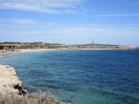
Zoomed
in on a lighthouse in the distance at Troubridge Point.

The
town sits onto of the cliffs – scanning around the coast to the lighthouse.


Through
town then down to McEacharns Beach.

The
concrete & steel power poles have been covered with tiles.


Past
another salt lake.

Kemp
Bay (another Council area) is surrounded by cliffs. Plenty of room to park at
the top and there is room down the road for a couple of vans. We drove down to
have a cuppa and chatted with the family from Shepparton.


These
signs are part of the Walk the Yorke trek. They have also put in picnic tables
under shelters and water tanks. Love the dolphin surfing photos.

Drove
back up to the cliff top, fabulous view – will come back here for sure.


Along
the coast to Suicide Point to a lookout and info about the wreck of the ‘Clan
Ranald’.


Someone
has stolen the anchor.

Looking
east to Troubridge lighthouse then back to the west.

Troubridge
lighthouse was built with custom made special wedge shaped clay bricks. Its
design is resistant to high winds and earthquakes, as in the early 1900s
numerous lighthouse fires were caused in the region from small earthquakes. It
is 32 metres high.

Over
the back is the Wattle Point Wind Farm.

The
road winds along the coast.

Up
to the lighthouse for a look.


Great
story about the locals helping the survivors of the ‘Clan Ranald’.

Fabulous
view.


Down
past the wind farm – all in rows. It was opened in June 2005. It is unusual as
it is located on flat ground. One of the largest farms in South Australia with
55 turbines. They stand 67 metres high and each blade measures 40 metres in
length.


All
the land here is covered in rocks which the farmers have spent many years
picking up. There are piles in paddocks or along fence lines. A few have made
rock walls from them. Otherwise the rocks are crushed and used for road base.

Into
Edithburgh and down to the wharf. Zoomed in some big silos and salt piles in
the distance on Giles Point.


Looks
like a good place to catch squid.

Back
around to the other side of the bay.

The
moon is out just above the sun, which is hidden by a cloud.

Edithburgh
is famous for its salt lakes. Great murals.


One
of the rail trolleys used to catch the salt down to the ships.

Grand
home – must have been for the head of the salt company. Lots of history to
explore here next time.


Walked
down the main street past the Museum. Closed at 4pm. Great mural.

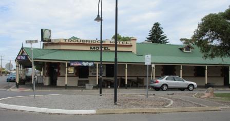
On
opposite corners are the two old hotels – Edithburgh Hotel established 1878 and
the Troubridge Hotel Motel established 1873.

Found
the anchor that was missing from the Clan Ranald lookout. They brought it back
to restore it and decided to leave it here in town.


Info
about the historical jetty.

Getting
late so we headed home on the main road. Past a couple of the many salt lakes
around here – one looked pink.


So
flat and open.

Moved
across to let a skink cross the road. Then a cat crossed over. Next it was a
peacock – then I looked back into the farm and there were geese and chooks
everywhere. Someone must have left the gate open.


Through
Yorkstown – another one to explore next time. Into Warooka then down to Marion
Bay. Stopped at the boat ramp – a charter boat had just come in with a group of
men in their blue fishing shirts. I had seen them touring yesterday with their
team fishing shirts on.
Went
for a walk along the jetty built in 1899 – breeze a bit cool now after such a
hot day.


A
great brochure from the Info Centre about farming on Yorke Peninsula. Another
one showed all the different crops so we now know what we are looking at – well
when there is a crop, not the stubble there is left now.


Back
to the van to cook yummy King George Whiting for dinner. Rang Kaylene and Rick
for a chat. Quiet night catching up on my blog. Still night which is a change
from the past few nights.
No comments:
Post a Comment