7am
13 degrees, clear sky and light cold breeze. Lots of tweeting and zooming
around from finches, spinifex pigeons, willy wagtails and galahs.
Headed
back down the track to the intersection then continued on the CSR – only a two
wheel track this side.

The corrugations started straight away. There were a few detour tracks to give us a break. Slow going but not as corruagated over wide flat country with high spinifex grass. Long bypass tracks as the straight main track is very corrugated – worst so far.


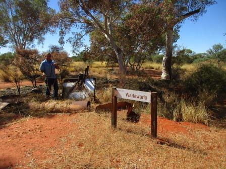
Well
32 was beside the track but is only a depression now with a few bits of tin.
Note the change of name again.
Well 32 – Mallowa (25 feet, 7.62m)
Canning built this well about 3.5 km from Mallowa
native soak because the soil near the soak was too sandy for stock.


We
turned off the CSR for 2km to check out Mallowa native soak which is in a basin
between sand ridges. A metal plaque on a star picked stated ‘Mallowa W. Canning camped 17-8-06 IEJ & PRM 5-7-86 Dug out M Yandle 11-6-85’.

Lots
of camel droppings around here and you can see where they have been resting in
the turned up soil on the other side of the soak hole.

Steve
got down the shovel and dug in the soak to find some water. The soil was damp
as he lifted it out then dug down a shovel’s length to allow the water to fill
in.


Didn’t
take long for the water to start seeping into the hole.

Back
to the CSR and over more corrugations but there were also a lot more detours.
Nearly making a new track – still open flat ground. Most of the time Steve is
doing about 30kph. More burnt areas. This one had a trailer which once would
have been hidden as it was a long way off the track. Maybe they planned to come
back for it.


We
pulled off the track and walked over to check it out. The burnt trees look
interesting – reminds me of Rebecca’s black coral.

Steve
checked out the trailer. It was for motorbikes and had broken and axle.

Finally
alongside a ridge for a while then up and over two ridges in a row then back
onto flat ground again. Through a section of burnt trees then the unburnt area.


At
the top of one ridge was a Stop sign facing north – someone’s joke I suppose.

Meandered
our way up and over and beside some low sand ridge and valleys between them to
the turn off to Well 31. There was a small metal plaque stating this track is
following the original CSR as there is a track that goes straight ahead but
that is overgrown now. Up and down some bigger sand ridges and through thick
tree areas for a long way – sugar blossoms and acacias.
Lots
of tall Snappy Gums appear as we head into Well 31 area. Around the ruins it
has been recently burnt. Another name change. Steve walked around the edge of
the well depression.


Well 31 – Wullowla (23 feet, 7.01m)
Differences in opinion between Canning and Snell
occurred again at this site. When Snell arrived in 1929 the well was in total
ruins so he built a new one about 3 km to the south east. When Canning came
through in 1930 he rebuilt the original well.


On
the map it shows another native soak but the track is overgrown so we will skip
that one. Continued along over lots of rocky ground (white limestone). Steve
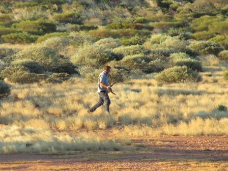
spotted a big goanna beside the track but he didn’t stick around for a photo.
Back to crawling along between 10 to 20kph over the rough ground. More low sand
ridges then we turned off to check out another native soak – Nurgurga. Our map
though says it is ‘difficult to locate’. There is another metal plaque at the
turn off so maybe it has been ‘located’ again though no one has been down this
track this year.
Came to an area of low green shrubs. Steve wandered around looking for the lowest point and found the soak though it is dry – he is a very good at this sort of bush logic. Don’t think we will dig this one.


Back
to the main track and continued along for a bit then we found some camel bones.


Continued
over the rocky track – nearly a bumpy as the corrugation. Through thick shrubs
which give the truck a whipping but they are better alive then burnt as they
are just brittle sticks then and really scratch the truck.


Big
trees appear as we head into Well 30 which is right on the edge of the track.

There
are two signs here – the original one (put in for the bi-centenary) that Canning
called it and the new version.
Well 30 – Dunda Jinnda (26 feet, 7.95m)
Canning was directed to native soaks nearby but
preferred this site for a well. Snell reconstructed Well 30 but Canning
criticised his work, claiming that it had to be rebuilt.


Had
lunch with the flies under a shady tree. Wind keeping it cool, 26 degrees at
1pm.
Found
another metal plaque sticking out of an old bucket on a tree stump. We presume
this is the tree they refer to that had a blaze on it.


Turned
off the CSR and followed a track over a few sand ridges for 2.6km down to check
out a spring. A flock of budgies flew out off a tree – lovely green ones and
very fast.

Mujingerra Spring
Heavy rains in 1999 and 2000 have caused the collapse
of the top entrance to the spring making it difficult to climb into the main
cavity. From the lower part of the depression a narrow shaft, about 10 metres
in length, leads to a small cave with its floor covered by crystal clear water.
The water is usually warm and a short swim to another larger cavern is rewarded
by view of beautiful clusters of chalcedony on the walls and ceiling.
It
looks more like a sink hole like the ones on the Nullabor. Certainly has caved
in so we won’t be going down to explore. That explains all the rocky area we have
been driving over – like a limestone bed under the sand ridges.


Lots
of holes around the edges – some go through to the bottom.


Back
to Well 30 then we continued on down the CSR – lots of white sand which is the
crushed limestone we imagine.

Turned
off again to check out another native well. Got to the dot on the Hema then
spotted a star picket which had a metal plaque otherwise we might have missed
it.


Nangabbittajarra Native Well
This well is an interesting water point set in a deep
limestone depression.
Unfortunately
the grass is growing well here so you can’t really see the hole.


Flat
country around here so you can see a long way.

Back
to the CSR and continued over more flat ground till we came alongside a sand
ridge which we ran parallel too for a while. Then we climbed over it. Took a
video as we hadn’t done any for a while.
Onto
straight sections as we run alongside the ridges which get quite corrugated.
Frightened two bustards out of the spinifex. On the flat we travel either over
flat spinifex or in narrow channels between the shrubs. Came around one bend
and met Mr Camel coming towards us. He wasn’t too worried and wasn’t in any
rush to get off the track either. Steve slowed drove closer till he decided he
had better make room for us to pass. Took a video.


With
the track clear again we headed off. Came out onto a big open ironstone area.


Crossed
a couple of sand ridges so took some videos. There was a ‘run-off’ area at the
bottom of one so Steve turned around and parked across the track so he could
get underneath and pull out spinifex etc while I put the kettle on. As we
haven’t seen anyone for ages we aren’t too worried about someone coming over
the hill!!


A
willy wagtail sat still long enough for me to take some photos – they are so
cute.


Still
very windy as we continue up and down sand ridges heading south. Crested one
while I was videoing it and we stopped at the top for a view over King Hill.
Looking along the sand ridge we just crossed over.


Passed
lots of low rocky outcrops.

Crested
the next sand ridge which had a wide top and spotted a plaque on a gum tree. It
was about a Father and Son trip completed in 2014. There were heaps of them.


As
we went down on to the flat we could look back on the southern side of King
Hill.

King Hill, Thring Rock and Lake Auld
These were all named by Larry Wells in 1896 after
members of JR Stuart’s expedition across Australia in 1862.
Spotted
a huge mushroom on the road so had to stop for a photo, of course.

Up
and down some more ridges. Took another video and when we crested it we had a
great view over Thring Rock (318m).

Unburnt
– burnt.


Crested
another ridge – zoomed in on Thring Rock.


As
it was clear around the base we decided to park here for the night. Drove
around it trying to find a spot out of the wind which is still blowing and
quite cool now the sun is going down. Set up camp. Took my camp photos and ones
of the rock – looks like some people have driven up over the saddle but they
have put big rocks there now.


I
climbed up the saddle. Looking back over the ridge we just came over.

Then
I spotted a bushman collecting firewood.

Back
down again – looks like someone has made a cairn. Don’t think we need to climb
up there and add a rock to it.


Lots
of different coloured rocks around the base which is amazing as the rock itself
is just all one colour.


While
Steve got the fire going I walked over to capture the sunset. I walked back
when the sun was still full to get my wine and when I walked back it was half
gone. Nice photo any case. 5.15pm sunset.


Looking
back to camp from where I was standing to get the sunset photos.


The
colour on the east side is sometimes prettier.

A
nice fireplace to warm our shower water and keep us warm while we have our
showers. Unfortunately the wind changed direction after sunset so we had to put
up the shower curtain to stop the chilly breeze.

Map
of this section of the CSR we have just done.

Played
a couple of games of Dice while we had coffee then into our warm bed. Leaving
the blue packing blanket on as well as our other blankets now. Dropped down the
kitchen door to stop the wind coming in that way too.
No comments:
Post a Comment