7am
11.7 degrees, clear sky and still windy.
Packed
up then went over with Phil and Kylie to check out the Army trucks. Very
interesting – Mercedes Benz chassis and engine with Australian made cabins etc,
only $330,000 each. The chaps and one lady (medico) were still finishing their
breakfast but made time to chat with us. Steve of course checked out the
vehicles – he wants a second axle under ours!

We
said our farewells to Phil and Kylie. They are heading to Newman to pay the
towing company – will hear how much later and get their vehicle checked over.
We told them to check out Carawine Gorge and Running Waters on their way there.
Kylie is keen to detect as their did a bit in Victoria so we might see them
again somewhere.
We
drove into Kunawaritji Community to fill up with diesel. This one will hurt,
$3.40/litre and we need a full load. The chap was very chatty – he and his wife
have been here 4 years. He said that all the fuel and food for this community
and Punmu comes across from Alice Springs via the Gary Junction Highway. He was
a singer and did some gigs around Cairns. Kylie had warned us that he might
sing us a song or too but he had to attend to something so after filling us up
he whizzed off in his 4wheeler.
We
went back around to the shop to pay our bill – ouch. Very neat and tidy. The
community housing is behind a gate stating locals only. The locals were in
buying all kinds of interesting items (all sugar based) which if they really
wanted to help themselves they would make sure those things were banned from
the shop. Then into a visitor accommodation area to fill up with water. There
were some other travellers there from Sth Aust who had just come across the
Gary Junction Track. They were using the facilities to have a shower and do
their washing in the laundry. They are heading up north on the CSR too. They
were the first group through last year on the southern section from here in May
and it was very wet then too.

I
wandered over to the medical centre where there were heaps of signs cutting
back on sugar etc.

As
we drove out they were lining up to get fuel – glad we got here early as the
other chap with his camper had just driven in too. Steve went to give them a
toot and the horn wouldn’t work. Back to Well 33 and onto the Canning Stock
Route again heading north-east.

We
were warned about the corrugations. Yes they are bad but we have had worst on
the Cape York bypass road. Took a video. Interesting there aren’t as many
bypass tracks on this section compared to the south section.
Turned
off to find Well 34. Crossed a wide open plain and then narrow sandy track for
5km windy our way around the end of the sand ridge. Back up along it till the
two ridges become close together. Across a salt flat area to the ruins of Well
34.
While
I put the kettle on he investigated the horn – the wire had broken and the horn
was just hanging there. Well we don’t really need one out here.

Facing
the track is the new name.

Through
the bushes to the well is a sign with the old name spelling. I wonder why they
haven’t removed the old signs!! Did our Well photos. Someone has beaten Steve
to it and dug out the well a bit to bring up a bit of water for the birds.
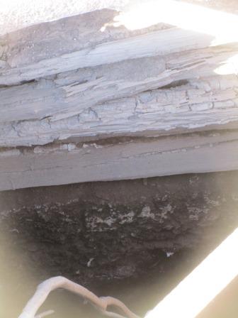
Well 34 – Nibil (17 feet, 5.2m)
Reconditioned by Snell but now in ruins.


Back
to the main track bumping along over more corrugations. A few more longer
bypasses which are nearly as bad as the main track. (You should see my notes!)
There
was even a bypass to bypass the bypass opposite Kidson Bluff area. Got Steve to
stop so I could take a photo.
Kidson Bluff
This bluff was named in 1956 by surveyor Veevers after
Mr Kidson, a member of the Carnegie Institute in Washington who carried out a
magnetic survey along the CSR as part of a worldwide project.


Met
the Callowa Track which we went on for 4kms to Well 35. On my map it meets Gary
Junction Road to the south-east. The Gary Junction Road was another built by
Len Beadell’s Gunbarrel Road Construction Party. It was built between Aug-Sept
& Oct-Nov 1960. Work was interrupted when the grader broke down and had to
be towed to Giles by the bulldozer.
Callowa Track
This track was built by Len Beadell about 1963. It is
part of a series of tracks linking Alice Springs with the Coast between Broome
and Port Hedland. It was built for the Dept of National Mapping. The track to
the west of Well 35 is now overgrown.
Found the new sign for the
well then through the bushes we found the pipe from the historical society but
the trees were low so couldn’t get in to see if there was any water in it.
Well 35 – Minjoo (16 feet, 4.9m)
This was the last well repaired by Snell. The
Geraldton Historical Society put the plastic casing down this well. Water is
very poor quality.


The
track continued on from here, up and down low sand ridges then through a flat
area of desert oaks. More small ridges, some gums and then more desert oaks.
Soft sandy track. I videoed a climb and some of the oaks.
Desert Oaks
The Desert Oak (Casuarina decaisneana) is a statuesque
tree often seen in areas west of the Simpson Desert through to the Gibson
Desert and as far west as the CSR. This forest is one of the biggest and best
to be seen along the CSR. The Desert Oak grows from seeds contained within a
hard cone and in its first stage grows to a height of about 6 metres and looks
like a straight, slender pine tree. As the tree matures it develops a strong
straight trunk and large weeping branches. It is believed that many of the
larger trees may be more than 500 years old.


Slow
going over the sand ridges as they are not smooth so just slow first gear to
crawl over the holes. Steve thinks those hire 4WDs we saw the other day may
have caused the holes.


Stopped
to check out a native well. We could see that the hire group had camped here
but we couldn’t find any sign of the native well.
Bungabinni Native Well
Canning sank a well at Bungabinni but decided against
its use because of a slow recovery rate. In 1987 Peter Vernon, accompanied by
Alfred Canning’s grandson and two great grandsons relocated Bungabinni. Two
years later a group, again led by Peter Vernon, rebuilt the well and scraped
access tracks between Wells 35 and 36.
Further
along we came to a sign. The right hand track is overgrown as I imagine
everyone would want to use the original CSR track.

Through
more desert oaks. Videoed a very bumpy sand ridge climb. Steve definitely
thinks the digouts are from those hire 4WDs with too much pressure in their
tyres and just putting their foot into it rather than a slow climb over the
ridge. He is figuring out ways to avoid them after trying to go up slowly and
not making it. Now he tries going up on the side and middle of the track for as
long as he can. Once on top it is all good.
Burnt
area with new regrowth.

Back
to spinifex and bushes and more woopsy sand ridges – another video.

Paperbarks
appear as we arrive at Well 36 for lunch. Still windy so parked under a
paperbark trying to keep the kitchen side away from the wind which blows up all
the dust.

This
one is now Kilkil and originally it was Wanda. Now how can a linguist say that
was written wrong from how it was said!!
Well 36 – Wanda (18 feet, 5.5m)
Poison Bush (Gastrolobium grandiflorum) occurs at
various places along the CSR. Canning had to clear it from this site while he
was surveying the route. Most explorers of the western deserts had problems
with their horses and camels dying after eating poison bush. Drovers were aware
of this problem so usually sent someone ahead of the mob to burn areas where
poison bush was known to grow. Eileen Lanagan, the only woman to travel the
Canning as part of a droving team, clearly remembers scouting ahead of the mob
to burn poison bush. Eileen and George Lanagan brought cattle down the Canning
in 1940.


It has been refurbished some
time ago but the pully block has been removed from the frame so you can only
use a bucket. Doesn’t smell too good. Obviously the water needs to be used
regularly to keep the water ok.
On the track again and heading east. More bumpy sand ridges, they are getting higher too. More video.

Further along Steve checked
out a Suzuki motorbike. He fixed up the suspension so it is all good to go
again!


We
crawled along the edge of a low sand ridge and up on top and ran along it for
quite a while in the soft sand – video. We were avoiding the basins of
paperbarks which probably could be wet at times.


Sand
ridges are closer together here. Slow crawling along the side then over to the
other side and crawl some more. Very bumpy track. Stopped on a ridge top and
got some firewood then continued the bumpy track crawling towards Well 37 along
the side and on top of the low sand ridges.

One
had two exits so Steve took the left one then swung around and went up the
other one. He said he wanted to go south-north then north-south then
south-north again. He didn’t tell me he was going to do it so I didn’t video
it. When I complained he said “do you want me to do it again!” I think I have
enough videos of going over the sand ridges and these were easy ones.
Through
some flat country with limestone rocks and more desert oaks. Past a nice
cleared area under the trees which would me a good camp spot. Further on to
open ground and the ruins of Well 37. Still has water in it and there are lots
of finches around enjoying it.
Well 37 – Libral (16 feet, 4.8m)
Canning sank this well close to a native soak, finding
excellent water. Tourists call this the Haunted Well (because of the murders
here) although it is doubtful that it was ever called that by the drovers.


An old sign points the way to
the graves.


Murder of Shoesmith, Thompson and
Chinaman
In January 1911, George Shoesmith, James Thompson,
Fred Terone and a half-caste Aborigine called Chinaman started their drive from
Flora Valley with 150 bullocks. This was to be the first drive down the CSR.
Within a few weeks Terone returned to Halls Creek suffering from
conjunctivitis. Tom Cole, following some months later with another mob, found
Thompson’s horse partly eaten at Well 45. By the time they reached Well 38 it
was obvious from the number of cattle wandering the track that something
drastic had happened so Cole camped his cattle and rode ahead. As Cole
approached Well 37 he saw the remains of the drovers’ plant scattered over a
wide area and found Thompson and Chinaman, who appeared to have been killed
while they slept. The body of Shoesmith was found some distance away and it
appeared as if he was killed while on watch. The attack probably took place on
the evening of April 24, 1911. Their bodies were found by Tom Cole on June 30.
I wandered up for a look
while Steve checked over the truck. One for Shoesmith and Thompson and the
other for Chinaman.


I couldn’t find McLernon’s.
Might be over under one of those oaks. The wind going through the oaks
certainly does make it sound spooky here and more so a night.
Murder of McLernon
John McLernon was in an oil exploration party which
was based at Well 37 in 1922. McLernon was killed by Aborigines while he slept
in a camp some distance to the east. Two other men fought off the attack and
brought McLernon’s body back to Well 37 where they buried it at the base of a
desert oak.

Looking
back to the truck and the well.

Change
of direction now to the north so back to straight over some medium sized sand
ridges again. Still with lots of bumpy bits so we had to crawl over them
carefully so not to bounce the truck around too much. Another video. Photo as
we crested it – following camel hoofprints now, was a dingo for quite a while.

Down
to the open plain then up again. Ridges are getting further apart again. Up and
down in first or second gear in high range seems to do it and getting out of
the main ruts to start with so you can keep a bit of speed to get over the
softer sand at the top.
Ridges
then get smaller and closer together again. On the Hema it should a mark ‘Rock
Art’ but all we could see was sand. Then we crested another ridge and on the
other side some rocks appeared out of the sand ridge. On my Canning Map it is
called Wandurba Rock. There was a cave which has a hole through it.
Wandurba Rock
Some faint Aboriginal paintings can be seen inside a
small cave thought to have been used as a shelter.


No
old ‘art’ just someone leaving their mark.

Climbed
up, past the hole that goes into the cave and onto the top to enjoy the view.


As
we were halfway up the ridge we had no run off for the rest of the ridge and
boy was it bumpy. Probably the worst yet and I didn’t have the camera ready.
Though
high shrubs again.

The
straight sections between the ridges are quite corrugated. I videoed the next
two ridges. The shadows are making it harder to see the holes in the track as
we climb up the ridges.


Over
some more whoopy climbs (more videos) – more ironstone rocks appearing and
gravel. In and out of little gullies. An old bike frame beside another metal
sign put in by the CSR Road Construction Company on 10th January,
1990 shows the way to Well 37, closely following the original CSR track.
Peter Vernon’s track
This track between Well 37 and 38 was built in 1990 by
pulling a steel scraper loaded with about one tonne of sand behind a Toyota
Troopie coupled to a 4WD converted Holden taxi. Peter said that with tyre
pressures down to 7psi they could pull the scraper anywhere.

As
the sun was going down we pulled into Well/Water 38 as it was actually a creek.
Water 38 – Wardabunni
Canning’s party blasted a large hole in the bed of the
creek but it was difficult to persuade cattle to drink at this water. Names of
some members of Canning’s party as well as some of the drovers can be seen on
the rock face above the pool. Grooves can be found where Aborigines sharpened
spears on the rock.


If
they wanted to change the names why didn’t they take the old ones away!! These
signs and some of the old troughing are up on the high ridge above the creek.
The
galahs weren’t happy about our arrival but have settled back into their tree in
the creek.

We
walked down to the creek to find the water.


Lots
of holes in the rocks and in the walls of the higher edge on the other side.


Will
investigate more tomorrow. The wind is still blowing hard so we parked to give
us the best protection for the night as there is nowhere up on the high ground
to get away from the wind.
Lovely
sunset colours.


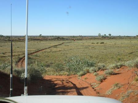
Today’s
section of the CSR we have covered.

The
wind settled so we had a lovely shower by the fire. Can’t get better than this.
A
dingo had a howl for a bit.
Lovely
dinner then a few games of Skipbo with the fire keeping us warm. I saw
something come out of the grass and it was the dingo coming to say hello –
might be used to someone feeding him. Steve shooed him away and he went off
reluctantly.
We
pulled the sides down of the truck to keep the cold breeze out.
No comments:
Post a Comment