7am
20.3 degrees, overcast. Worst night’s sleep so far. The wind was wild but we
had closed the kitchen door and had the wind break up on the bed side so we were
ok. Unfortunately there was something loose in the Ranger’s camp and it banged
all night. About 4am the wind stopped for a bit and a few drops of rain fell.
No evidence of the rain now though.
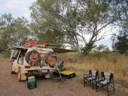
Packed
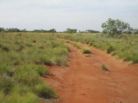
up camp then chatted with the others telling them about the track south. Only
two wells left for us. They said the track was good from here north so Steve
put some air in the tyres, back up to 30 in the front and 40 in the back.
Continued driving between two low sand ridges.
Nice
camp area further along under some desert oaks.

A
bit further up was another burnt vehicle. Steve thinks it was a Toyota Prado.
Wow it saw some heat.


More
corrugations over the straight flat sections. The sky is clearing to the west
but still grey and heavy to the east. Over a slight rise for a lovely view of
new green spinifex, brown anthills and red sand ridge on either side. Can’t
capture it well enough in photos but it is really quite pretty.
Turned
off into Well 50 (62 feet, 18.9m).
Again only a depression and some bits and pieces. Steve said it looked like
there was some of the original timber troughing here.


Continued
along the track to find Culvida Soak. Spotted three camels in the distance –
eagle eye Steve. They just stood and stared at us till we passed them.
Travelling
on some high ground above a sandy creek, which we have been following since
leaving the well. We appear to be heading to some ironstone hills then we turn
and go to some lower ones. Parked on a rocky area then headed down into the
creek.
Culvida Soak
The soakage is about 700m upstream from the end of the
vehicle track. Carefully explore the left side of the creek bed to find an
interesting gorge, a covered pool of cold water and numerous Aboriginal rock
markings.


Walked
along through the sand and past a ironstone capping over the limestone coming
down the hill on the other side.


I
thought this looked like a tiger’s head.

Continued
up the creek.


Steve
spotted some arrows carved into the rock edge near a big fig tree.


I
found some nests under one overhang.

A
bit of water appeared on the edges.


Steve
went up a narrow gorge and found some etchings and Noel’s name engraved in 1931
(stockman maybe).


There
is water trapped here on either side under the rocks too.

Back
out to the creek and we walked further around the bend past the bits of water.
The creek seems to go uphill here so this must be the low point hence the water
stays here.

Had
a cuppa when we got back to the truck then followed the track back again. This
is where the creek would flow out onto the flats near Well 50. The gusty wind
is back.

Back
to the main track. Passed another abandoned 44 gallon drum. Steve wonders if we
should put in a tender to remove them all from the CSR. Might be a money
maker!!
Straight
sections of track so more corrugations but not as bad as the north and south of
Well 33. Spotted a couple of camels. When I took the photo it looks like ‘push
me-pull me’ from Dr Dolittle.


Startled
a bustard, flocks of budgies zooming around and lots of ‘zoom’ birds darting in
front of the truck. Reached the intersection of seismic lines used as wet
weather detours around Lake Gregory though the sign doesn’t indicate that. Nice
straight tracks.
Lake Gregory Bypass
Huge floods in the Kimberly sometimes cause Lake
Gregory to flood well above the level of the track. In 1993 the edge of the
lake was above Well 51 and within 2 km of the seismic line used as a bypass.
Few, if any, signs point the way to Halls Creek so travellers must regularly
check their position.


We
continued on the CSR.
Another
wrecked Toyota Hilux dual cab.

Grey
soil flat country – lots of grey anthills too.

Spotted
the windmill at Well 51 as we crossed a low sand ridge.

The
last well that Canning and his team built.

Well 51 – Weriaddo (22 feet, 6.7m)
This well was built under extremely trying conditions.
Canning was away getting supplies. The men were exhausted and starving and the
heat and flies were intense. The greatest disappointment may well have come
when they finished the well to find that it produced only poor quality water.
The huge windmill is going
around but not pumping any water. There is another well beside it – it stank.


Walked up and checked out the dam – dry. Looking back to our truck. The windmill makes it look really small.


Continued through grass
pastoral land with only a bit of spinifex on the low sand ridges we are
crossing as we head north. Far to our east is Lake Gregory which looks lovely
in the photos when it has water in it but we won’t be going there as we need
another permit. The map showing Well 51 at the bottom left corner and the green
CSR reserve following Sturt Creek going up to Old Halls Creek where Canning
finished.

Lots of galahs and budgies
around. The track leaves the actual CSR reserve near Guda Soak and is just west
of Overflow Creek as we head north. I spotted some cranes and zoomed in.


Back into spinifex covered
land again. Startled 4 more cranes further along – got an in-flight photo.

Took a video crossing little
sand ridges of red dirt again and corrugation on the straight sections.

Through a desert oak forest
which is currently smouldering and some logs still burning well.


Followed 3 bustards walking
down the track for a bit until they got the hint and flew off. Steve enjoying
zooming along at 60kph – he can smell ice cream at Halls Creek. Zoomed along past more burnt
sections.
At Bloodwood Bore there is
another windmill going around and not bringing up any water. We pulled in here
to have lunch under a shady tree. The sun is out but we are still heading towards
clouds. Checked out the fencing and troughs now disused. Looks like the
pastoral company the aborigines were given aren’t running cattle any more.


In
the end we didn’t meet any on-coming vehicle on the actual track – only in the
camp spots. I am glad as some of those narrow bits between the bushes went for
a while so someone would have to back up and I certainly didn’t want to meet
anyone at the top of a sand ridge!! Decided to take down our poor flag –
getting a bit tattered. I didn’t leave the knickers up there – might need them
one day!!


Continued
on till an intersection – turn off to Mulan. The sign faces the ones coming
from Billiluna, both aboriginal communities.

On the other side of the
track was a great CSR information board. Interesting reading – I didn’t realise
Snell had given up at Well 35 which is why Canning came the following year to
finish them and decided to redo them all again. Amazing man.


More dead cars appear on the
side of the track – not CSR ones, locals.

Turned off to check out
Stretch Lagoon. First we passed old cattle yards and sheds.


I read the information in the
shelter while Steve went over to chat with 3 Rangers from Halls Creek. They
have been destroying feral dogs and checking on the aboriginal rangers at each
of the communities.


I walked down to the water’s
edge – not very pleasant.


Continued on to Billiluna
(Mindibungu). Information from the Shire of Halls Creek booklet -In the 1970’s some Walmadjeri people who had
been resident at Balgo Mission returned to Billiluna Station because of their
family and historical associations with the cattle operation there. The
catalyst that made this possible was the purchase of the pastoral leases by the
Australian Government on behalf of the Aboriginal people. The newly established
Aboriginal owned Tjurabalan Pastoral Co Pty Ltd now assumed responsibility for
the running of the cattle operation.
Peaceful – not many dogs left here!! Mostly neat with a few houses needing repairs.


Billiluna Station
It covers 400,000 acres (160,000 hectares) and was
first taken up by Joseph Condren in 1920. Two years later Condren and his
friend Tim O’Sullivan were murdered by an Aborigine named Banjo. The men were
branding cattle and sent Banjo to get a rifle. He returned and shot both
Condren and O’Sullivan. After Condren’s death the station was taken over by the
Billiluna Pastoral Company in 1925 and then by Robert Falconer, a major
shareholder in the company, in 1934. Falconer appealed to the government to
have the stock route reconditioned resulting in the 1929-30 Snell and Canning
expedition and also the 1942-44 reconditioning. Billiluna was purchased by
Spencer Doman in 1948. The CSR was used by Doman cattle until the last drive in
1959 led by Mal Brown. He is credited with the most trips (11) up and down the
CSR. In 1977 the property was sold to Arthur Young & Co who then sold it
the following year to the Aboriginal Lands Trust.
Spotted
a ‘bottle’ tree on the edge of the sports ground or is it a boab. Will have to
look up the difference.

Reached
the Tanami Road (no longer a track) and turned left towards Halls Creek
(168km). We will be back on this when we head south to Alice Springs later on.
Nice wide smooth road. This is the end of the official CSR track for us as it
follows the river now up to Old Halls Creek and we can’t go that way.


Good
road with a bit of corrugation. Open
flat country. Past Wolfe Creek Crater turnoff – will do that on the return
trip. Lots of cattle on the side of the road.
More
flat open plains then big hills start appearing.

Through
a gap in the hills.


Stopped
for a cuppa by the roadside and Steve tipped in 25 litres from one of the jerry
cans on the roof just to be sure we make the distance. Very dusty here but
luckily the wind was blowing in the other direction as cars zoomed by us.
A
bit further up was a track leading to a dam – should have stopped there! Crows
and a wedge-tailed eagle were arguing over some roadkill.
Past
Ruby Plains Station homestead – one of Sid Kidman (the cattle king) properties.

Ruby Plains Station
Ruby Plains Station was taken up around the turn of
the century by Walter Darcy and a friend who accidently drowned soon after
while digging a well. Jim Darcy, a younger brother, was seriously injured when
a horse rolled on him. The ensuing operation, done on the Post Office counter
by the ‘bush doctor’, Postmaster Fred Tuckett under the guidance of Dr John
Holland in Perth and communication by telegraph, was successful. Unfortunately
Jim died of other complications before Dr Holland could make the 2000km trek to
Halls Creek to provide aftercare. On his return to Perth Dr Holland said that
next time he was confronted with similar circumstance he would fly to Halls
Creek. Dr Holland was talking to Rev John Flynn, later to become the founder of
the Royal Flying Doctor Service. Ruby Plains is now owned by the Kidman
Pastoral Company.
Had
to stop for a herd of goats to cross the road.


Continued
up and down through rolling hills. Steve spotted our first wallaby since
leaving Well 2. Turned onto bitumen for the last bit into Halls Creek on the
Great Northern Highway. As we aren’t towing anything he can do 110km!!

Into
Halls Creek – I think that is part of the Metrological Station.


Found
the Post Office to pick up our 40E permits so we can go detecting. Nice artwork
on the high school nearby.

Checked
out the fuel prices at the 3 outlets. The cheapest is the Coles Express @
156.9c/l and if we purchase $20 in store we will get the 10c/l off. The others
were 164.0 and 169.0. Will come in tomorrow to do that and get some food from
the IGA and Coles Express.
Headed
out the Duncan Road (goes south than turns and heads up the WA/NT border to
Kununurra) and back onto the dirt through more hills – feels like Nullagine
area. Still heavy clouds hanging around us.


Turned
off to find Caroline Pool to camp for the night. Great sign.

Drove
down into the creek and parked near the pool – not as much water in it as in
the photo in the booklet but enough to give us shower water for tonight.


Dry
the other way.

Found
a dead cane toad – oh no!! Looks like the crows are doing a good job though.


Our
camp for the night with water views – sort of.

Lovely
sunset colour.

Last
shot of the map showing our final leg, though we still have to get to Old Halls
Creek to finish the Canning Stock Route journey (will do that tomorrow).

Nice
quiet evening as no one else came to camp here. There is toilets up the track a
bit which have just been installed by the look of the shiny handrails.
Played
a few games of Skipbo and enjoyed a nice long shower.
No comments:
Post a Comment