6.30am
13 degrees, clear sky and cold wind that was coming in the bedroom side so now
the wind is coming from the east and getting stronger. We woke to the mournful
howl of a lone dingo. He went on for half an hour walking around the top of the
rock by the sounds of it. We didn’t see him.
Packed
up with the wind getting stronger. Continued down the CSR. Steve (the
beachcomber) is always on the lookout for discarded things in the bush and
today he found a table. The plastic top is just starting to crack up. Should
have left it set up for travellers to stop and have a cuppa at.

The
track became eroded again so up onto the bypass through the spinifex. This
track has been here for a while as it is starting to get eroded so a new bypass
will be needed soon.


We
had to turn back north and back over some sand ridges going south to north
again towards Well 29 (45 feet - 13.74m when it was dug – no other info about
this one) which was in the middle of a flat plain between the sand ridges. Only
a bit of the troughing and a depression under the trees where the well used to
be. More discarded 44 gallon drums here.


Back
along the track we just came in on then over the same sand ridge from north to
south this time. Took a video of the next ridge crossing.


Across
more limestone rocky sections between the sand ridges. These ridges seem easier
going north to south which is why a lot of people do that direction and also
for those towing trailers. The sand doesn’t seem as soft either which maybe
because of the increase in the limestone around here and of course it is 10
degrees cooler now than when we were coming north a few days ago before the big
detour.
Stopped
to check out a wet section of track. Steve walked along and decided it was all
good. I took a video in case it wasn’t!! It was all good and we could see wheel
tracks on the other side of someone who has been through here recently.


Down
to the end of the ridge then crossed it into the next section which was burnt.

Up
and down ridges then along the flats between the ridges weaving our way slowly
south. Finding the sand is getting softer on the top of the ridges. Next flat
section was quite eroded so took the bypass.


Two
camels were using that one too. They took off in a trot. We haven’t seen any
big herds down here.


Few
more ridges then up a rocky hill with a view to the north west of Lake George,
this is the one southwest of Lake Auld. Had to zoom in a long way to see the
water. Southwest of George is Lake Winifred.


Lake George
This lake was named by Charles Wells in 1896 (one of
the lost men from Larry Wells’ party).
Lake Winifred
This lake was named by surveyor Rudall during his
search in 1897 for the two men from Larry Wells’ party.
Crested
another ridge and stopped for a photo of the burnt ridge on the other side.


Steve
then spotted a dingo coming up the track towards us. I videoed him as he wasn’t
afraid of us at all. He has a brown snout so maybe he is a cross-breed which
they are now called ‘wild dogs’. He continued coming towards us sniffing the
air then went up on the ridge and stopped behind some grass not far from us.


As
we didn’t move he headed off back down the track – doing his boy’s business as
he went along. Another video.
I took a video of the view. Looking at it I realise I need to slow down in my panning.
The dog/dingo kept going along the track turning watching us as we slowly drove behind him so I videoed him again. Eventually he decided he better go into the spinifex till we passed.

Down
into the middle of two ridges traversing eroded track then up onto another
bypass to skirt the worst bit which took us all the way to where Well
28 ruins are (30 feet, 9.16m when it was dug – no
other info about this one). Lots of soft sand being blown around here in the
wind and a few relics are nearly buried now.


Mr Dog/Dingo arrived. He just moved around keeping an eye on us – maybe hoping for
something to eat or drink but I refrained.


Steve
continued with his digging and the dingo just sat in the shade watching. All
finished so we headed off leaving Mr Dingo to dig for his own water.


This
is the original track – glad we took the bypass.

Across
the flat to the burnt sand ridge I took photos of before. Videoed crossing it.


More
burnt ground with fresh green regrowth on the flats. Lots of the ridges have
double crests to them and some we run along in the middle for a bit before
crossing the other side.


We
are going over the ridges then straight across the flats here rather than the
long run parallel with the ridge like we were doing in the southern section.


Some
of the flats are just spinifex and others have the bushes so it is only a
narrow track between the trunks. Glad we haven’t met any oncoming vehicles.


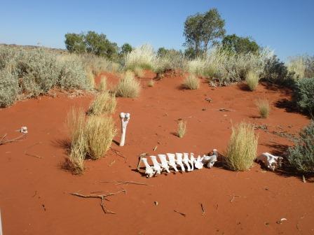
On
the top of one ridge we found a camel graveyard. Steve tried to put him back
together again.


Down
onto the flat for a long run parallel with this ridge.

Across some low ridges
to the turn off to Separation Well. 78km down and back so we will skip this one
– not that we are allowed to anycase. A metal sign stated that the track had
been rediscovered in 1979.
Separation Well
Found by Lawrence Allen (Larry) Wells on October 3,
1896. He was commissioned to lead the Calvert Expedition to explore an area
from Lake Way north to the Fitzroy River then to Powell Creek on the Overland
Telegraph Station returning to Coolgardie. From this point the party separated,
intending to meet again at Joanna Spring further north. Heat wave weather
conditions caused tremendous hardship to both animals and men and an incorrect
positioning of Joanna Spring on Warburton’s maps meant that both parties missed
it. Wells’ party barely managed to stagger on Fitzroy River while two other men
perished about 14km from Joanna Spring.


Continued
along the flat then videoed another ridge climb with the view of three hills on
the other side. I think one of them is Helen Hill (352m). This hill was named by Charles Wells in 1896.


Don’t
think we will be taking the original track, it has been replaced with a new one
some time ago.


Around
the edge of lots of rocky hills. The track is very rocky too.


Past
a big flat hill.

Back
over double sand ridges then a patch of limestone brings us back to a crawl
again.

Areas
of salt pans then we went across one.


More
eroded track and more bypasses. The bypasses have only been pushed through this
year.

Stopped
at Well 27 for lunch. Only a bucket in front of the depression with a little bit of sludge in the bottom. Nothing here indicating any heritage site.
Well 27 (24 feet, 7.31m)
Canning dug this well about half a kilometre from a
popular native soak. This well is near an important Aboriginal heritage site.


Continued on over a couple of
ridges with Slate Range appearing to our left.


Up a sand ridge but on the
other side it turned into a rocky descent. Will be an interesting climb back up
when we return.

A white dingo appeared on the
track. Got a video of him. He wanted to stick to the track too but after a
while turned off into the spinifex and waited till we passed.


Slate Range continued –
stopped on top of a ridge to take a video view.


Lots of zooming willy
wagtails flying along in front of us. Some leave it nearly too late to zoom off
but we have hit one yet thank goodness. On the Hema it shows a spot - Canning
Camp 1907 but we couldn’t see anything other than some trees in a gully.
Passed some more interesting
hills. Not sure if that is a track going up but we aren’t going over to find
out.


Over a ridge then onto a flat
section. Spotted a newly pushed track going off to the left and then this
bogged section. Stopped the truck to investigate. We don’t want to be bogged
too.


The ground looks dry but you
can see deep holes where the camels have gone down in the wet ground.
I think these look
interesting. They must curl up like that when they get burnt.

Steve came back declaring it
was safe to drive over which we did but I still think it is still a bit damp
under there.

Further along we spotted some
red and found some Sturt Desert Peas. Such a fascinating flower.


Went along slowly through a
very rutted section.

Crossed over another burnt
sand ridge. My camera just can’t capture the long length of the ridges. Must
admit we both thought the ridges would be barren rather than covered in
spinifex and trees as they have been. You really only see the redness of them
when they have been burnt.


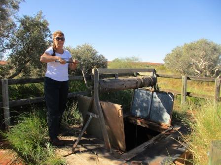
Arrived at Well 26. Canning
reported that this well could make 2000 gallons per hour of quality water.
Looks like we will only have missed Well 25 now.

Since I had my 2 Geckos
Travelling t-shirt on the boys gave us when we left Steve decided I needed a
photo of that. Tomorrow it will be 3 years and 9 months since we left Cairns.
The memorial was opened and the well reconditioned in 1983. It is a replica of
a camel water tank typical of those used by early explorers and prospectors.


Well 26 – Teiwa (23 feet, 7m)
In 1983 a party led by David Hewitt carried out the
first well reconstruction in recent times. David was supervisor of Aboriginal
Housing and carried out the negotiations with the Jiggalong Aboriginal
Community who allowed the reconstruction on this registered Aboriginal heritage
site. The project involving 25 people was completed in 8 days and marked the 75th
anniversary of the stock route. Harry Gough, an engineer, was in charge of well
reconstruction and Bill Holdsworth, an architect, took charge of the cairn
building party.
Steve found the visitors’
books in a box near the sign nearly hidden by a shrub now. Now we know who we
were following on the track around Well 25. The family we met at the Well 6.
They were game but they made it through. Before them are the two vehicles who
were bogged in April and the note from the towing company with a few of his
business cards in the box – hopefully we won’t need his number.


Checked out the reconditioned
well. Track Care restored this well in 2011 and put in the toilet in 2012.
There are a couple of fireplaces though the grass has taken over. My turn to
bring up the water – heavy bucket! Steve took a video.


I wrote in the visitors’ book
but forgot to take a photo of it. We decided as it was still early we would see
how far we could get. We had the waypoint mark on the Hema where we turned
around on the south side after we had gotten around the wet area of Well 25.
We
headed off and were running parallel with a sand ridge when we spotted a
bustard on our right. Got the camera out as he flew off then we noticed a camel
to our left. It moved quickly along a bit then Steve said there is something
else in the grass.


To our amazement a baby camel
stood up on wobbly legs and tried to get a drink from mum. Of course I got the
video going by then. Mum was not sure about us and moved behind the tree. Poor
baby stood there wobbling and braying for mum to come back. We decided we
should move on so baby can get its drink. Now that was a very special moment I
won’t forget.


Over the next ridge and we
spotted a herd of camels below us. Probably waiting for mum to give birth and
catch up to them.

Also a very boggy track.
Maybe this is where the people in April got bogged and had to be towed out.

Steve walked it to make sure
it was ok for us. Don’t need to be ringing the tow company. As he said he had
to use 300m of cable it looks like he just scull dragged them out and they just
gouged up the side of the track. Further along were very deep juts where they
had stopped – sitting in water!! Looks different now it is dry. Of course we
now know the Dekkers had pushed through here too so don’t know if they had
problems and made some of the ruts too.
Will have to give them a ring some time. Steve said there is also the
vehicle in front of us (I didn’t see their entry in the visitor book because I
wrote under the Dekkers and didn’t turn the page) but it should have been dry
like this when they came through two days ago.


The camels weren’t too
impressed and the big bull had a bit of a grunt at Steve when he walked towards
them. He just shouted back and they slowly moved off. I told them mum and baby
were doing well and should join them shortly. Took a video of them moving off.


Looking back to our truck.

Steve put some branches and
spinifex in some of the deeper ruts then we walked back to the truck. Steve
said it was all good for us to cross as he could see the other recent vehicle’s
tracks and they hadn’t sunk. I took a video.


Over another sand ridge and
onto the flat. We had commented that the other vehicle must have gone through
or else they are sitting bogged somewhere. Across some salt pan area which had
a feel of being a bit damp underneath. As we came down off a low ridge and the
track turned we saw water and something white further ahead.


Sadly they didn’t get through!
We could see the back of the vehicle was open so Steve gingerly walked along
the edge trying not to fill his boots with mud or water. I walked down a bit
but as soon as I went too far the mud sucked at my boots. I zoomed in and
realised it was a bed in the back of a camper. Steve got down to the tree and
called out but the wind is still howling so he managed to get around the tree
and saw two people sitting in the car. Boy did she get a surprise. After some
chatting they walked up the wet track with Steve and I met Phil and Kylie from
Sydney. They were very embarrassed as they don’t normally do silly things like
this. They weren’t doing the CSR but had come across on the Gary Highway
heading to the coast. As Phil had done the CSR before he thought they might
detour down to the Talawana Track and go across to Newman from there. They had
heard mixed reports about the track condition and had read Dekkers comments
about it being wet and just sticking to the track. Unfortunately this is how
far they got and they have been sitting here for 2 days and nights. Luckily
they could get into their bed at the back of their Tvan and could cook on the
stove which is out the side (very low to the ground as the camper is in quite a
hole). They had their Sat Phone and had rung 000 and were put onto the
Jiggalong Police. Unfortuately they couldn’t do anything for them. They tried a
few communities but didn’t get a reply. Eventually they got onto the Newman
Information Centre and onto the Swan Towing Service. Probably should have taken
one of the Pilbara Towing cards as he knew how to get to them after just being
here in April. The Newman chap unfortunately came up from Georgia Bore (like we
had done) and couldn’t get through so he was doing the big detour – hence they
were still sitting there. They were in good spirits and hadn’t killed each
other so that was good. We all had a good laugh about it – well what else can
you do!!
After much chatting Steve convinced them to give it another go at getting out. They had spent one day trying but weren’t getting anywhere. He had MaxTraxs and we had our Treds and with some thicker tree trunks he thought they might be able to get the car up onto some drier ground further on. Then he could pull the camper through to him. Unfortunately they also means further away from us and further for the towing company to pull them back but at least they would be on drier land.
Off with the shoes and we walked back down the track. The base is actually very solid but you move a foot off to the side and it is very boggy. As I walked down I could see water everywhere.


Phil
had already unhooked the car from the camper but it was down in a hole and the
diff was stuck on the high bit in the middle of the track. Steve got his
highlift jack out (only been used once or twice before many years ago) and they
set about lifting the wheels to get the trees and treds under the wheels. After
a few goes it moved forward and onto harder ground. Got that on video. Will
have to give Kylie copies of these when this is all over.


Now
to drag the camper out. I didn’t get a photo with the back panel down in the
water and the angle of the kitchen so it doesn’t look that bad now. With a lot
of grunting and moaning (some by Kylie) they dragged it towards the drier
ground. Unfortunately it had built up a pile of mud and spinifex on the left
wheel it was just digging a huge rut off to one side so they couldn’t get it
onto the hard track surface. More digging, pushing and pulling and at last they
were on dry ground. Another video.


With
lovely lake views – more laughing of course. The track is wet on the other side
too.


A
bit more manoeuvring and they had the camper connected back onto their vehicle
and were ready for a dry night just as the sun was going down. Another video.


We
laughed that they would have to go and get water so they could wash their feet
in before getting into bed tonight. They were both extremely thankful. Kylie
had managed to get onto the towing service again and let them know they were
out of that bog but still need help. Steve thinks he can get them turned around
and then with our winch and the two snatch straps get them back onto dry land
again. He said the track base is hard and the trick will just getting back past
where they had been bogged. Kylie was unsure but Phil was keener to give it a
go. We said we would go up the road a bit and camp for the night then come back
and look at it all in the morning.
Back
in our truck I did a measurement from here to where I had marked it past Well
25 where we turned around – only 5km away.

We
backed up and turned around, Steve noticing the ground was very soft even here
as soon as you go off the track. Drove back to an open area and got a fire
going for our shower and we had heated up some tin meals and a cuppa soup. The
wind has settled but it is quite nippy. Today’s map.

We
played a few games of Skipbo till it got too cold then went to bed with the
side door closed. Hope Kylie and Phil are having a better night’s sleep.
No comments:
Post a Comment