6.30am
12.4 degrees and the cold wind is still blowing. Lovely watching the galahs and
budgies zoom around. Even managed to get a photo or two and videoed the budgies
zooming.


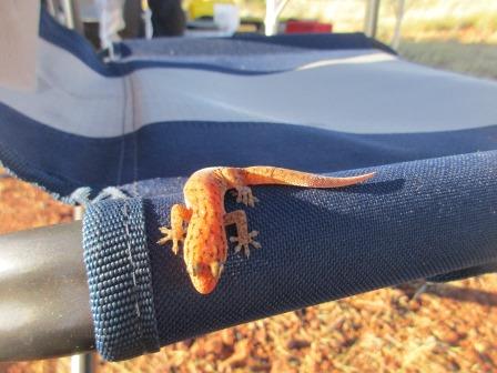
Steve
found a friend perched on his chair.
We
packed up then walked down to check out the ‘well’.


Lots
of cave/holes going through the rock. On my notes it said not to park too close
as the area around the well is soft. Should say ‘could collapse’.


On
the roof of that one we found the ‘aboriginal tool sharpening spot’ mentioned
in my notes.

Steve
found the engraved names above the water hole to the left of where we walked
down.


As
we headed off Mr Dingo appeared on top of the low ridge beside us to say
goodbye.

West
for 3kms to the intersection of the ‘other’ track and another sign by the CSR
Road Co. My other map showed this section as impassable now and it looks like
no one has used it for a while.


Onto
flat ground where the corrugations begin again. Up and down the sand ridges –
Steve’s having fun. Not too bad but still dug out by the group in front of us.
Steve approaches the ridge and says ‘what have you guys left for me this time’.
Videoed a couple of quite lumpy ones but Steve has got it under control and we
avoid most of the bumps. But sometimes you can’t avoid the holes so he just
crawls up in low range and hopes for the best.


We
are just going straight over one ridge then straight to another ridge and over
– no running parallel in this section. The ridges are starting to get higher
too. I got out for a couple and walked up so I could video him coming up the
ridge. One was in low range and it bogged at the top so he had to back down and
come up again in high range.


Videoed
another one which had two crests with a little basin in between then a lovely
view on the other side. I thought it was the track leading off but the track
turned right at the bottom and what we were looking at was a very long run off
for those coming south.
Crested
another one and stopped to check out a survey marker. Will have to look into
the difference of a survey marker to the bench markers we have been following.


Looking
back along the ridge we are parked on.

Nice
view over a breakaway area ahead of us too.

Around
to the breakaways – looking down the valley between the sand ridges though with
all the spinifex you wouldn’t know it was the Great Sandy Desert.

Few
caves at the bottom of the breakaways.


The
wind is still blowing hard so we went around the end of the breakaway to try
and find a spot out of the wind for a cuppa. Still windy but we had a nice view
over a salt pan area.

Across
a flat open area just south of Well 39 so this might be the pastoral block
mentioned in the notes.
Into
the paperbarks and grey soil to find Well 39.
Well 39 – Murguga (16 feet, 4.9m)
Canning marked out a large pastoral block around this
well but it was never used.


Two
signs again. Someone left their broken roof rack as a cover for the well. Long
piece of water trough. There is a bit of water in one corner.
Our
butane canisters are struggling with the cooler weather. We have to give them a
rub to warm them up so they can release the gas. In Tassie we used to store
them in the glovebox so we could use them. Don’t think I want to here with all
the bumping we are doing. Will have to put them in the sun at breakfast
instead. After a cuppa Steve decided to dig this one out a bit more for all the
finches flying around us. He stuck a branch down there too so the birds can
perch on it. It slowly filled up again.


We
stood back and watched as the finches came back to the tree above the well and
slowly worked their way down to the water again.


Continued
up and down the sand ridges – more videos for the boys to watch.

Into
desert oaks again. Couple of nice areas for camping. Some one left their mark
on a piece of metal.


Arrived
at the edge of Tobin Lake which was named
after Michael Tobin who was killed during Canning’s return survey trip in 1907.
Of course no water just lots of salt bush. A big sign facing the other way says
they are entering Martu Country so hence we are leaving it and heading into the
other half of the first permit we paid for.


Very big lake area. It is
part of the Percival Lakes system according to my map. In the distance the
mirage makes it look like there is water. Obviously it doesn’t get much water
as the track is great and Steve is zipping along in 4th gear doing
60kph. On the other side we found the sign.

Back to the lumpy climb over
the sand ridges again. Steve mutters some words about the ‘Germans’ ahead and
their driving abilities. These ones are lower and closer together as we get
closer to Well 40.


Turned off for long drive
alongside a sand ridge to Well 40 but kept going to check out Tobin’s grave
first which is 250m north east of the well beside a tree. Lots of 44 gallon
drums discarded around here and the well. This grave was erected in 1908.
Michael Tobin Grave
During the return of the 1906/07 survey expedition
Michael Tobin was speared by an Aborigine near the native well about 15 metres
from the present site of Well 40. Reports by Canning suggest that Tobin may
have surprised the native who threw at least three spears before being shot by
Tobin. A deep wound in Tobin’s chest caused his death several hours later.
However, an account from Tjama Napanangka, an Aboriginal woman reputed to have
reliable recall of the old stories, claims that a tall, middle-aged Aborigine
named Mungkututu sent his young wife to Tobin to ask for tobacco and Tobin kept
her with him for two days so her husband came looking for her. He speared Tobin
and was shot. Tobin was buried with the best Catholic ceremony available. His
grave is on a sand ridge about 300 metres from Well 40. Mungkututu is believed
to be buried in an unmarked grave nearby.


A new grave for Mungkututu
has been erected further along on the top of the rise.


Back to the well for our
photos. Well 40 – Waddawalla (12 feet, 3.6m) – it has a new name too.
There is a hole with damp dirt underneath but we won’t worry about digging for
water here.


Spied a hawk in the tree and
zoomed in.


Headed back along the track –
startled a dingo who was very timid and cut for over the ridge. Stopped for
firewood on top of a ridge – nice solid dead gum tree. More wreckage beside the
track. Steve stopped to check it out – a cracked water tank.


More videos of climbing up
the bumpy sand ridges – some needed two attempts as he would try and climb up
slowly but then didn’t have enough momentum to get over the top. We are trying
to avoid the holes and run up on the edge where we can so as not to dig them up
more. Unfortunately this tree got us so
we had to back up. Steve removed the tree and we went up and over easily.

Turned off into Well 41 to
have some lunch. We planning to stop for the night so I could do some blogging
– so far behind!! But it wasn’t very
pleasant so we had lunch and took our photos.
Well 41 – Tiru (19 feet, 5.8m)
Positioned by Canning because of the soil suitability
for cattle and the availability of feed.


It had been restored many
years ago with a frame and pulley but hasn’t been used and the water was not
very pleasant smelling.
Back onto the main track and
over the sand ridges again. More videos of another one that needed two attempts
as he tried in low range but needed more speed so went up in 2nd
gear high range.

We are heading into the
taller sand ridges through here – some up to 17 metres so more videos. They
don’t look too bad in the photos.
Might be the Great Sandy
Desert but it is very pretty and mostly covered with something. Even after it
has been burnt it doesn’t take long for the little green shoots of spinifex to
appear and give the place a lush look.

Through a large burnt section
which gives us long views from the top of the ridges. These ridge climbs are
better though they are topped with softer sand. More videos.

Sadly haven’t seen any camels
then I spotted the remains of one.

Another video of a climb –
got to the top in high range then stuck it into low range and crawled over the
top.
Spotted a hawk with something
so zoomed in and he was having his lunch – lizard.


Up and down the sand ridges –
more videos. Past the turn off to Helena Spring which is now a disused track
and it is 87km to the east.
Helena Spring
This spring was called ‘the diamond of the desert’ by
David Carnegie who named the spring after his sister. Carnegie’s party spent
five days at Helena Spring on October 1896. Temperatures reached 60 degrees C
as the party took their first bath in 7 weeks.
Up and over another ridge
which I videoed and on the other side was a nice spot under a gum tree beside a
run off area. We pulled up thinking we would stop here but the wind was
whipping up the loose sand so I decided my blogging could wait and we continued
on.
Really is amazing how green
it is in the Great Sandy Desert – we had expected it to be more barren.

Across next ridge and spotted
a salt pan which is Guli Lake. Well 42 is at the southern end of it.

Well 42 – Guli Tank
This excavation is set in a natural sandstone
depression collecting water filtering through the bed of Guli Lake. Although
now almost completely silted up a small hole still holds enough water for small
birds and animals. Thousands of budgerigars have been seen using this water.


Went back and checked out an
old fuel tank that travellers had used as the visitors book. Found the Williams
brothers and Jerry that we met at Durba Springs. We still haven’t met anyone on
the track itself coming down the CSR. We know we have the Germans in front of
us and there is the SA group following.


Steve cleaned out the hole
and made it a bit bigger. The finches were straight back into it once he had
finished.


Walked around the area and
sadly found rubbish. I wonder if these people leave rubbish in their own
backyards!!

Across Guli Lake, covered in
low salt bush. Not as smooth as Tobin Lake as this one has lots of limestone
rocks.


We stopped for a cuppa, 26
degrees though the sun is burning on my arm.
Easier sand ridges but more
corrugation on the long flat sections. Steve can see where the motorbike chap
from Narrogin has driving on the middle of the track rather than in the 4WD
tracks.

There is a track on the map
that goes west then north (note saying bike & trailer remains) but you miss
all the wells. Doesn’t look like it has been used for a while.

We turned east and headed to Well 43.

As we came over a rise we spotted
camels below us. I said for Steve to stop so I could get a photo and he said
there is something strange about these ones, they have things hanging off them.
Then we remembered hearing about some chaps bringing camels down the route.


Drove down to the well and
their camp. Anthony and Steve were just going over to bring them in for the
night. They were hobbled and were just having a nibble on the grasses there. He
gave them a whistle hoping they might come over to us but they just stood and
looked. They are all girls and are feral ones that have been trained by a chap
in Perth who has a camel ride tourist attraction at Kalamunda in the Perth
Hills.

Eventually with a lot of
talking and dragging they got the camels over to where they had a long rope
between the trees to tether them up for the night. They couldn’t walk very
quickly with those hobbles on. The guys spoke nicely to them which was lovely
to hear. Took a video.


We asked if we could stop
here for the night and they thought that was great. Though Anthony warned us
that the camels can get very noisily early in the morning and that they would
be up about 4.30 to start loading them. It takes nearly 3 hours to get all 5 of
them loaded again. I said we would be happy to be part of it all so we backed up
on the opposite side and set up camp.

Our map for today’s travel.

We went over to photograph
and video the camels. They carry about 150kg on their specially made saddles.
They can carry half their body weight. Anthony and Steve had spent the past 18
months preparing themselves and the camels for this trek. They have a Facebook
page, Great Sandy 18, so will have to put some photos up for them when I get
signal again.


Also to do the well photos
too. The boys had been trying to dig it out to get some water for the camels
but didn’t have any success.
Well 43 – Billowaggi (19 feet, 5.8m)
A young Aborigine died at Well 43 in 1952 while
bringing down a mob of Doman cattle with Len Brown in charge.


Anthony unhooked one of the
girls for me to pat. Steve took some photos and a video.


Steve got a fire going and
the boys joined us for a nice glass of wine – bit of a luxury for them. They
did have port but drank most of that with the crew that first came out with
them at the beginning. Anthony and Steve are from Fremantle and have been
friends for years though they are both questioning their devotion now they have
been walking with 5 camels for 18 days!! Anthony’s ancestor (uncle) was
Warburton so he thought it would be great to see what it was like for him to cover
part of the Great Sandy Desert.
Warburton Expedition
Peter Egerton Warburton was born in England in 1813
and arrived in Adelaide in 1853. He was appointed Commissioner of Police.
Warburton began exploring areas of South Australia around Lake Eyre. In 1872 he
was commissioned by Sir Thomas Elder to explore an area from Alice Springs to
the Western Australian coast. In April 1873 Warburton set out from Alice
Springs with his son Richard and five other men. By the time they reached the
WA border the party was suffering from lack of water and scurvy. Warburton was
hoping to cross Gregory’s tracks along Sturt Creek but believed an error in
navigation cause him to miss it. Several days after four of their camels died
from what they believed to be chills. Warburton found and named Joanna Springs.
Warburton’s party struggled for the next 10 weeks trying to escape from the
desert to the Oakover River, a distance of about 800km. All men were very weak
and Warburton had to be tied to his camel so that he could travel. They reached
the Oakover River in December 1873.
They walk about 20-25km per
day and we checked the map and they still have 220km to go till Well 33. They
will get in some floats and load the camels there for their trip back to Perth.
They only had one altercation with a bull camel further north near Breaden
Hills. They are also raising money for RFDS and Melanoma WA. They brought over
their dinner as they need to hit the sack by 6.30pm since they get up at 4am.
It is dehydrated but much nicer than what the chap on the motorbike was eating.
They had met him and gave him one of theirs for a taste. A friend who works in
a Uni as a dietician created these ones which are made by a chef then sealed.
They just add some water and a little oil and leave for 15 minutes. Looked nice
– this one was Chicken Mango Curry. For breakfast they have one with apple and
cinnamon. Lunch is another type.
I asked permission to video
our chatting as it was fascinating. Steve told the story of how they were
walking along with the camels behind them discussing what they would love to do
when they get back to Freo then looked behind and they only had one camel. The
others were standing back on the track luckily as they could have just run off.
They had forgotten to connect up one hook between the lead and the rest of the
camels.
They had given the camels 60
litres of water at Well 46 and filled all their drums as they knew the next
wells weren’t good. Steve told them what water we had found at each of them.
Steve offered to heat up
water for them to have a shower. They would have loved one but decided they had
to be true to the adventure. After a cup of Milo they headed off to bed at 7pm.
We cooked our dinner and enjoyed our hot shower – this is enough adventure for
us. Into bed early for us too at 9pm as we might have an early wake-up call.
No comments:
Post a Comment