6am
19 degrees and the wind is back. Lovely sunrise though with the cloud cover.

All
grey and very blustery wind from the ESE. The others are early movers and were
gone by 7am.
We
left at 8am. Across the flat plains then over the first little sand ridge.

Lots
more in a row and they slowly got taller. Stopped on top of a ridge for a
photo.

A
dingo trotted across the track in front of us.

Wind
whipping up the dust today. Had to put up the windows and turn on the air
conditioner for the first time to stop getting drowned in the dust.
Otto’s
group have still left us with dug up sand ridges but the others in front of us
have flattened a few out.

Through
a burnt section. Looks like a dust storm out there.


Onto
Seismic Line section from oil exploration days – long straight tracks that
don’t actually go anywhere. On maps you often see it say ‘navigation danger -
cleared lines’. As it is straight the corrugation is back.

Back
to the normal track which is straight and corrugated too.

Back
over the sand ridges again and into unburnt country so not so dusty.
Across
wide spinifex flat. Turned west for 4km to Well
47 (24 feet, 7.3m).
Only the ruins, trough and a depression where the well once was.


Headed
back to the turn off then headed east for 22km out of the actual CSR. Can’t see
why we didn’t continue following the original ‘green’ track on the map. But we
have to go where the track is. Heading towards some ‘mountains’ that started
east of Well 45 where there was another bypass track which went up through
those ‘mountains’. According to my map this is Mt Elgin (355m).

The
track went between low sand ridges and back into soft sand track with lots of
curves in it so Steve was having fun in ‘rally’ mode. Hang on Sharon.
Looks
like the track goes up and over that hill. I didn’t like the look of this side
so we drove around the other side. Steve started up it as I videoed then I said
stop as it was looking too steep for me. The Perth couple had mentioned it
saying they headed up then saw there was a crowd of people standing at the top
of the track.


Steve
was a good boy and backed up then went a bit further around and drove up the
gentle slope. As he says ‘happy wife, happy life’ – smart man.
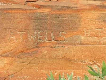
It
is blowing a gale up here and quite chilly but we managed to get the kettle on
and made a cuppa. People had written on slabs of rock – found the Williams
brothers again.


I
got out a marking pen and left our own slab.


Great
view from up here if you don’t get blown off. Took a 360 degree video.

The
track we came in on and where we are heading to – presuming one of those is Mt
Romily (352m) with Mt Elliott (429m) and Mt Stewart (381m) somewhere in there
too.


Continued
east through more soft sand with detours around eroded sections.

Turned
north east where the southern bypass track joins this one. Flocks of green
budges zooming around. Burnt sticks and green regrowth through more sand with
slabs of ironstone rocks in piles.

We
are heading across the Southesk Tablelands. I thought it was the hills like our
tablelands at home but I think he called all this flat ground, tablelands, like
a table top.


Southesk Tablelands
These were named by David Carnegie after his father,
the 9th Earl of Southesk. Godfrey Massie found a natural dam filled
from a huge stone catchment as Carnegie’s party was searching for water during
its exploration of this area in 1896. Carnegie named this Godfrey’s Tank. While
the party was wondering how to get the camels to the water, Joe Breaden,
another member of Carnegie’s party, found water in a valley now called Breaden
Valley.
David Carnegie, born in London in 1871, sailed to
Australia in 1892 and worked as a miner and prospector in the Coolgardie area.
In 1894 his search for gold led him on a trek of about 1000km through
unexplored country. Later that year Carnegie discovered gold at Lake Darlot but
he became seriously ill with typhoid fever while travelling across the desert
to Coolgardie to buy supplies. Carnegie barely managed to stagger into
Coolgardie. During a long convalescence in Perth, Carnegie drew detailed maps
of his explorations for the WA Government. In mid 1896 David Carnegie set out
to cross WA from south to north as most of the previous exploration had taken
place in an east-west direction and huge areas were yet to be explored. Godfrey
Massie, Charles Stansmore, Joseph Breaden and Breaden’s Aboriginal servant,
Warri, made up the party. Carnegie was responsible for the European discovery
of Empress Spring, one of the most unusual in the western desert, also Mt
Gordon, Mt Everard, Helena Spring, Southesk Tablelands, Godfreys Tank, Breaden
Valley and many other features. Charles Stansmore accidently shot himself and
was buried in the Ramsey Range about 60 km west of Halls Creek. Carnegie’s
party arrived at Halls Creek to the news that two members of Well’s party were
lost in the desert. After several weeks rest Carnegie set out for Flora Valley
station where he purchased replacement camels and horses for the return
journey. After travelling south to Lake Gregory they made for a range Carnegie
named the Stansmore Range after his friend who had died a few weeks earlier.
The party struggled on, losing animals to poison bush and exhaustion’ men also
suffered from lack of water, exhaustion and sandy blight. When Carnegie
eventually reached Lake Darlot he had travelled about 5000km in 13 months.
Carnegie left Australia in 1897 and learned to speak Arabic while convalescing
from surgery in England. He was appointed to the civil service in Nigeria and
in November 1900, at the age of 29, was killed by a poisoned arrow while trying
to apprehend a rebel native.
Michael Terry’s Expedition
His motorised expedition of 1925 travelled down the
stock route from Billiluna to the Southesk Tablelands.
Up
and down some little ridges as we get closer to Breaden Hills and back onto the
CSR proper. This is called Crown Head.

Stopped
and took a video to get it all in. Looks lovely.


Spotted
a survey marker on the ridge.


Turned
off the main track and headed 4km into the valley to find Godfreys Tank and
Breaden’s Pool. Lots of interesting hills – one with a chimney and another like
the Pyramid. The track wound its way through the grass (no spinifex) and
powdery grey soil – would be a boggy place if wet.


Found
the sign – now to find the pool.


Lovely
spot.

Would
be great to see it flowing as that would make a lovely waterfall.

Lots
of fig trees trying to survive.


Back
to the sign – 20 min walk to Godfrey Tank gorge. We walked over to the next
little gorge but that didn’t go anywhere. Steve climbed up on the hill for a
look. There were some rock cairns. I looked at my map again and then saw a
track heading up onto the hill above our truck so went up there. Nice view of
the valley from up here.

I
continued walking along the top of the ridge above Breaden’s Pool as it looked
like the tank was up that gorge from my map. Steve had climbed over the hill
and only found some more cairns so we continued up the gorge. Found a hollowed
out area that could be a ‘tank’ and it would definitely be too difficult to get
animals down to get water from it. There was a hole on the top side too. We
couldn’t see anywhere that had names engraved.


We
walked back then around to a rock cairn on the next hill. Great view. Took a
video though all you can hear is the wind instead of what I was saying.

Steve
went walking following a track which I though was from animals. There was
another cairn on the next hill so we figured it was just someone who likes
building cairns wherever they go!

He
was gone ages. I kept looking out for him and then I saw him off in the
distance waving his hands. He seemed ok so hopefully that means he has found
Godfrey’s Tank. I followed the track – pretty wildflowers are beginning to
appear.

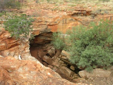
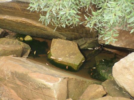
Eventually
I found him sitting on the side of a big hole.

It
was amazing and there was water in the bottom.


There
was a creek running down and it went over the wall and down into the gorge. A
big hole to the right would make a nice spa pool.


I
went around to where Steve was sitting as he could see all the names engraved
on the wall from there. These were some of Canning’s people and stockmen who
used the CSR. We were trying to work out how they did that. Steve thinks the
slab in the bottom of the tank was probably a ledge some time ago as one is
dated 1942.


I
was videoing the view and zooming in on the names when I had the feeling
something was moving near me. It was a dingo and the poor thing was so thin and
obviously very thirsty as it wasn’t interested in us, only the water way down
below. I wish I had some to give him as he looked so sad. I videoed him as he
worked his way around the edge getting so close to falling over at times I
thought. Eventually he worked his way around to the other side then along.
Hopefully he will get down and find some water.


I
went around a bit further for another view into the cave area.


We
then walked back over to the other side. Looking back up the creek.


Looking
back over the ground with the gorge works its way through the hills.


Back
to the main cairn for a selfie at the top.


Now
to follow the track back down to our truck. Back down to the flat a bit further
along from where we had originally checked out a little gorge. We can now see
they have left little cairns marking the way but they needed a big one at the
start or a better sign.


Back
out to the main track – looking at Crown Head as we go around it.

Continued
on 2km to Well 48. Steve going for a dip in the well.


Well 48 (65 feet, 19.8m)
The recovery rate of water seeping into this well was
very slow so an underground tunnel was built to increase the storage capacity.
This was a common practice in well sinking. The capacity of Well 48 was much
larger than other wells on the stock route because it is believed that this
well, at the junction of the Canning and the Christmas Creek – Godfrey Tank
Stock Route, would be often used. (Christmas Creek is to the north west.)
Took
some photos then a video of the hills from the well as it is too hard to take a
photo of them all at once – need a panoramic shot.

Another
photo of the next lot of hills.

Continued
on the flats around the hills. Zoomed in on Twin Head.

More
hills then I noticed the one on the left looked very flat like it was a mining
tailings dump (which it isn’t).


Further
around past Mt Ernest (361m) and Chinamans Hat.

The
track turns eastward now. This burnt out Ford Explorer is now famous as it is
used as a mark on the Hema maps.

Some
interesting ‘quartz/limestone’ blows starting to appear. It looks like the
goldfields with little mounds appearing everywhere and thousands of little
anthills.

Finally
back beside a sand ridge again which we followed till we reached Well 49.

Steve
spotted this camel. He didn’t move at all while we slowly drove past. Then he
put his head down and carried on eating.


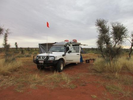
A
sign appeared then we saw a shed as we arrived at Well 49. No one here other
than another two vehicles camping so I didn’t bother getting out our permit.


It
has good water so a nice shower tonight. Took a video. The well was
re-constructed in July 2001 then the top part was redone in July 2013.
Well 49 (50 feet, 15.2m)
The quality of water in this well earnt it the title
of the Crystal Well. Jack Smith died at Well 49 in 1939. George Lanagan
reluctantly allowed Jack to join his team although George had known that Jack
had been badly hurt when a horse fell on him some time earlier. Jack Smith
became very ill by the time they reached Well 45 so he was sent back to Halls
Creek with two dingo poisoners. Smith died in his swag at Well 49 and was
buried by police who made the 800km round trip from Halls Creek.


Walked
over to the grave of Jack Smith nearby.


Chatted
with the other couples from Toowoomba then set up camp. Map of where we
travelled today.

There
is a Track Care toilet here – the only one so far on the northern section. It
was 3.40pm and only 23 degrees as the dark clouds and wind have kept it very
cool. I worked on my blog while Steve got some water and got the fire place
ready at the back of the truck. Our new set up works well – the fire keeps us
warm while we have our showers and it keeps the fire a bit protected from the
wind.
The
wind dropped about 5pm so we had our showers and got dinner cooked early. It
was gusting again by 8pm. A few drops of rain even fell as we were getting
ready for bed. Made sure everything would be ok then crawled into our nice warm
bed.
No comments:
Post a Comment