At
7.30am it was 12 degrees in the van and 5.3 degrees out. No wonder we don’t get
out of the van till 10 each morning!!! Another shower of rain around 6am, just to
soften up the mud some more!!
The
sun has come out after a cuppa though it is still only 8 degrees outside. Drove
down the muddy Reedy Lake Road to Nagambie. Don’t think we will take the van
back over these dirt roads if it rains more – we can go around the long way to
get back to Graytown tomorrow and only do 3km of dirt.
Passed
as sign for a camel farm as we headed towards Nagambie – the Horse Capital of
Victoria. Missed getting a photo of two horses’ statues as we crossed the
Goulburn River. Drove in to town and parked beside Lake Nagambie.

Some
rowers were out practising.

Interesting
plaque for the Uniting Church which was located 30 meters from here beside the
lake.

After
118 years there it was destroyed when a semi drove straight through it in 2003.

The
Pelican was part of an artistic enhancement of public places project.

Walked
out onto the lookout which is over the pumping station.

The
water is then pumped up to the water tower across the road.

Beautiful
statue of Black Caviar who was born on a property nearby.


Info
board about the Nagambie Lakes.


Wandered
down the street. Another very wide one like at Rushworth.

Stopped
at the Info Centre for a map and some history brochures. A lot of the old
buildings are gone now. It is a more modern town then Rushworth. In 1872, the
township of Nagambie (an Oorillim tribal word meaning slow lagoon) after being
known as the Goulburn Valley Road district. Nagambie was the third important
link between Melbourne and Shepparton for communication and transport. Rail
came to the township in 1880. On Sept 28th, 1868, an area of 166
acres was gazetted as being reserved for sale as title for a village. Ludovic
Marie surveyed what is now the town centre. With the construction of the
Goulburn Wier in 1891, and the flooding of the swampy area, the horseshow
lagoon became Lake Nagambie. Today the Goulburn Valley is a major wine and food
producing region of Victoria.
The
Royal Mail Hotel (1871) was built by Cr William Sheehan. The Cobb & Co and
overnight coaches used the Hotel as a stopping place for mail and passengers.
The original building was burnt down and rebuilt in 1891.

Looking
back up the main (High Street) street from the other end.

St
Malachy’s Catholic Church was constructed of granite and brick in 1872.

The
Flour Mill was built in 1870. In the 1900s flour in sacks were bought by locals
that was produced in one of the two flour mills in town.

The
Post Office commenced in this building in 1887 and over the years was also the
Telegraph and Phone Exchange. Next door was the Colonial Bank (1873) which
operated until 1930 when the National Bank took over. The building is
constructed of locally quarried granite blocks, slate and hand-made bricks.
Over the years it has been used as the RSL clubrooms, private businesses and is
now a private residence.

There
is a dark cloud coming and the wind has picked up and it is freezing. Steve
reckons -5 degrees!! Jumped back in our very dirty truck and sat there with the
heater going for a bit to warm up!!

Love
the big wide streets with two lanes each side. Steve commented that the
carparks are bigger too. Plenty of room to park the van on either side of the
road.

Drove
out of town to find the bridge Pete & Penny had to negotiate when they were
heading up to Whroo. It is called Kirwan’s Bridge. There is a 6 tonne load
limit and 3 metre height clearance so we are glad we don’t have the van on.


It
crosses one end of the Lake where the Goulburn River flows.

Boy
certainly an unusual one with a bend in the middle.

Lovely
old boats line the shore with their private jetties.

Turned
around and headed back over the bridge again – very busy too.


Lots
of wineries around here. This is Kirwan’s Bridge Winery where there is a
restaurant too.

Back
into town and we parked beside the Major Mitchell’s Memorial cairn where he
crossed this area in 1836.

Went
into Mawsons Bakery – there are lots of takeways etc here. Had a yummy pie for
lunch and a very good cuppa.
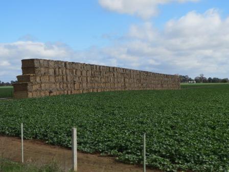
Headed
back out of town to find the Goulburn Weir. Passed a wall of hay.
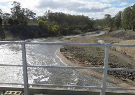
Parked
near a nice picnic ground and wandered down to the weir. It is 212 metres long,
15 metres high, has nine radial gates and two overshot gates that can release
up to 96,000 megalitres per day.


You
can walk out onto it during the day. Quite spectacular. It was built in 1891
but was refurbished between 1983 and 1987. All the newer steel radial gates are controlled by remote control.


Looking
back over Lake Nagambie.

Then
down to the water flowing down the Goulburn River.
Around
the other side to the old generator house.
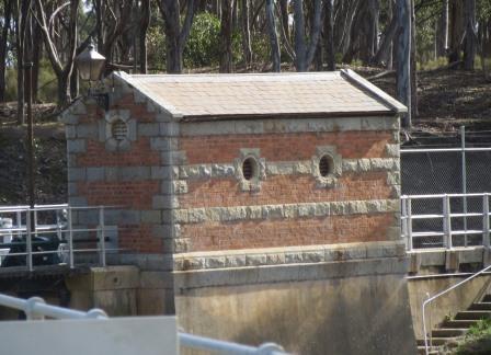
The
water is thundering out under our feet as we walk over the top of the open
gate.


The
water is right at the top of the old gates.
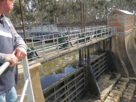
The
old version of the drive shaft to raise the gates. The weir itself is built of
concrete, with its downstream face stepped with granite blocks. The original
design featured 21 cast iron flood gates (6.1 metres wide and 3 metres high).
All the concrete used in its construction was imported from England, while the
granite blocks were quarried from Mt Black, about 24 kms south-west of the
site. The blocks were transported on horse-drawn drays along the rough tracks
from near Graytown. It the dray got bogged the blocks were dumped and could not
be reloaded because of their weight. Some of these blocks may be seen along the
old tracks.


The
newer nine steel radial gates.

When
the weir was first built, water turbines provided the power to raise and lower
the gates. The drive shaft ran along the full length of the weir as seen here. One
of the first hydro-electric turbines in the southern hemisphere was used to
light up the weir at night (hence the street light), a sight that attracted
visitors from all over Victoria.

Walked
across the next bit over the Stuart Murray Canal (he was the engineer) that takes
the water to Waranga Basin.

Looking
back to the weir.

Up
to the carpark on the other side.

Back
to the picnic area and we found the information room. Could have done with a
sign pointing to it!
The
Weir project was approved by Parliament in 1886 after a pumping station was
built at Murchison. The weir was completed in 1891. It had 21 overshot flood
gates made of both cast and wrought iron. Water turbines provided the power to
raise and lower these gates. The weir cost 113,500 pounds to build in 1891 when
the average wage was forty-three shillings and five pence per week.


During
the construction a township grew. A church and school were built, the
Commission employees operated a Post Office from 1887 for workers on the Weir.
After the Weir was completed, picnic grounds were laid out on the river banks
to cater for the many visitors and tourists. The Goulburn Weir forms Lake
Nagambie and provides a controlled water level close to the main street in
Nagambie. The lake used for water sports and leisure activities.


On
Christmas Eve 1893 visitors gathered from far afield at the Weir and picnic
grounds. Brass bands played and a marquee was erected for musical performances.
By
1905 there were 90 irrigation and waterworks trusts. Most faced financial difficulties
due to inadequate storages to supply the abundance of channels, no co-ordinated
management control of the sources of supply, and lack of understanding of
irrigation techniques. This situation lead to the Water Act 1905, which set up
the State Rivers and Water Supply Commission to take over the task of water
conservation and irrigation management in rural areas.


On
Armistice Day in 1918 flags representing the 8 Allies flew on the Weir. A large
rally was held at the Weir to honour the occasion.
The
weir was of such national importance that an illustration of the weir featured
on the half-sovereign note from 1913 to 1933.

New
Year’s Day sports meetings were held regularly during the 1920s and 30s.
Special trains ran from Melbourne to the popular sports days at the Goulburn
Weir.
After
World War 2, Victoria developed further and there was a boom in the
construction of water storages. The most prominent example was the enlargement
of nearby Lake Eildon.
After
nearly 100 years of continual operation, strengthening of the Weir foundations
and replacement of the superstructure were necessary. The reconstruction work
was completed in 1987. The new design utilises 9 steel radial gates between new
concrete piers. The historical significance of the Weir structure was
recognised. Two of the old Weir gates have been rebuilt in their original form.
The retention and conservation of Gates20 and 21 and the adjacent turbine house
are now significant features of the new structure.


The
Weir raises the level of the Goulburn River so that water can be diverted by
gravity along channels to supply irrigation water to Goulburn-Murray Water
customers. Water travels via the Stuart Murray Canal, Cattanah Canal and the
East Goulburn Main Channel to supply the Central Goulburn and Shepparton
Irrigation Areas. The Goulburn Weir covers 1,130 hectares and when full holds
25,500 megalitres of water. Because of the weir the level of Lake Nagambie is
constant so locals and visitors can enjoy water sports etc all year round.


Great aerial shot.


Great aerial shot.

Back
to the van and over the East Goulburn Main Channel.

Back
up the Goulburn Valley Freeway then we turned off at East Murchison where there
is an old Railway Hotel on one side of the railway line and a service station
on the other. Just before crossing over the Goulburn River again we stopped to
check out a lovely old building. The Bridge Hotel was built in 1868-69 and was
used right up to 1971. There were lights on in a bottom room where we could see
a ladder and there was a caravan out the back so someone might be restoring the
building which would be wonderful.


The
Oriental Plane Tree which was planted in 1913 is now protected by the National
Trust.


Drove
down under the bridge.

Then
back up and over the Goulburn River into Murchison.


Back
along the edge of the Waranga Basin and past some old original cottages like my
great grandfather, William Brotherton, built in Woodford, Qld. Just one room
with high roof and a verandah. Then later they build another room the same on
the back. I tried to get a photo but it didn’t come out.
Into
Rushworth and I showed Steve some of the sights and checked out where to get
water at the Recreation Ground. Stopped for a detect and to collect firewood
before heading back to the van. Pete was still out detecting and Penny was getting
the fire ready. Got it going and made some great coals for our roast lamb and
vegies dinner. Yum Yum.
Unfortunately
no gold for us from Whroo but it was a lovely place to spend a week and to be
with friends.
Watched
the V8s in Ipswich on One – we so miss free Channel 7 broadcast and I can even
admit I miss Mark Skaife’s commentary as the commentary is so lifeless now. Lou
sent a text also saying it was boring commentary.
Hi there - I hope you see this comment. I would like to get in touch with you about potentially using an image on this post (of the pelican sculpture at Lake Nagambie) in a book I am writing. You would be credited, of course, e.g. 'Image Courtesy of...'. Could you please get in touch with me - I couldn't find a way to contact you directly. My email is aclarke1[at]usc.edu.au . Thanks so much!
ReplyDelete