7am
12 degrees in the van as it is drizzling with rain so not as cold overnight.
10am
9 degrees outside as we had a cuppa in ‘our backyard listening to all the birds
in the aviary’. So good – if it wasn’t so cold!!
Penny
texted that Today Show’s money has jackpotted to $110,000 so I have entered.
You have to answer the phone saying ‘I wake up with Today’. Apparently a lady
answered ‘hello’ and missed out on $90,000 – now that would be crushing. I have
written a note and put it by the phone for when I answer it – how’s that for
positive thinking!!
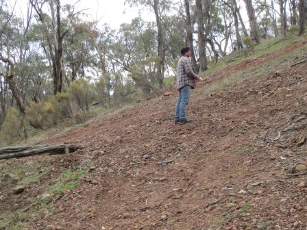
Headed
off to explore along the dirt roads to find Mt Black and Melvilles Lookout.
Stopped at some ‘State Forest’ type bollards below Mt Black. Wandered up the
road to what looks like a hill climb. I climbed up further to take a photo –
very steep – made my knees wobble. Nice view though from halfway up.

Looking
up to the top.

We
are at a steep angle.
Looking
down to the truck way below.

Steve
stopped to check out a crash site where a car must have flipped doing the climb
as there was rubbish everywhere. Found an Eagles CD, money, some nuts and bolts
(which of course Steve wanted!!) and the guy’s probation licence receipt. They
must have been partying hard too as there were grog bottles everywhere.

Steve
wandered up a bit further and found a spanner – definitely a beachcomber a
heart.

The
crash site.

Drove
on a bit further to the turnoff to Melvilles Lookout and then wound 2km up the
hill. It is also used for hill climbs. Melvilles Lookout is a prominent ridge
where Captain Melville reputably waited in ambush for miners during the gold
rush. Nice area at the top complete with picnic tables and fireplaces. Elevation
of 320 metres.


Map
of the area we are exploring.

Looking
back to Mt Black where the hill climb was. Mt Black is the highest point in
this area.

Looking
in the opposite direction from Mt Black – I think over Puckapunyal Firing Range
area.

Lots
of bird boxes here, probably for the Swift Parrot.

Just
left of Mt Black I could see the water in Waranga Basin glistening in the
sunshine.

Lots
of fat grass trees here too.

Back
down to the turnoff to check out the Mt Black Quarry (240m elevation). The granite
quarried from here was transported by horse and wagon to use in the
construction of the Goulburn Wier. Of course the graffiti artists and hoons
have dumped their grog bottles in the bottom of the quarry.

You
can still see the marks where they ‘cut’ the stone.


A
nice clean piece of granite.

View
back from the other end of the pit.

As
we headed off we found another quarry hole on the other side of the road. Back
out to the main bitumen road then we turned off to find Majors Creek
campground. Through farming area then along the boundary of Puckapunyal
Military Area. Lots of electric fences and No Entry signs.
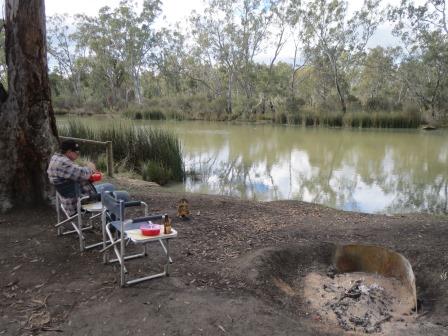
Found
the boat ramp and picnic area by Majors Creek. Got out the chairs and had lunch
by the water. The local chook came to join us for lunch.

Drove
on a bit further and found the actual campground. It was big but all muddy.
Looks like a heap of cars have been in there churning up the ground. There was
a family camped there. The information board about “Major Mitchell’s Trail” has
been wrecked. Further down the very potholed road we found an entrance to
Puckapunyal.


From
here we crossed over Majors Creek.

The
first house had this cairn out the front. “Major Mitchell camped here Oct 8th,
1836.”


Through
Mitchellstown which is now just a few farms.
Then
we came on a huge winery, Mitchelton, with a big timber fence going for miles
around it – would have cost a packet.


Has
a very impressive observation tower.

The
wineries here must love all the available water as they are surrounded by it
with Majors Creek and the Goulburn River which we crossed again. Glad we don’t
have to go over that old bridge.

Nearly
across to the Goulburn Valley Highway but we turned off another dirt road and
headed back up to the Heathcote-Nagambie Road. Past another big winery then
around the fenceline of the stud where Black Caviar was born – small sign said
Gilgai. There were more horse statues by the fence and some in the paddock with
the cows.
Back
across the Goulburn River again and onto the bitumen back towards Graytown.
Passed the Nagambie Speedway – looks a big turnout.
Back
into Graytown we turned off into the POW area for Steve to check it out. He
drove up more tracks and found more foundations further back in the scrub near
a dam. Down the track past the cemetery and then we meandered along looking for
other places to detect. Found a puddler by the road and Steve says you can see
where the area has been worked over by a dozer etc. Up Surface Hill Road (named
because they have ‘surfaced’ the area by scraping the top soil off and
processing it. Found the Surface Hill Dam. Another nice spot to camp too but
not with the van.

Back
onto Ballieston Road, that we started on, to check out some workings. Steve
went out with his detector while I read in the truck enjoying the sunshine.
Unfortunately he only came back with three bullets.
Turned
off into Boundary Road and past the van to check out what is further up the
road. It just keeps going and follows the boundary of a property – hence the
name. Headed back to the van for a cuppa. The sun was shining then we heard
heavy drops on the van and a minute later it was sunny again!!
Tried
the Best of the Eagles CD Steve found and it works but has a few scratches – oh
well can’t be too fussy. I worked on my blog and Steve went out for one last
try to find some gold.
Unfortunately
no more gold from here. Will head back to Heathcote tomorrow to where we found
a piece of gold at Argyle.
Steve
checked the temp at 10pm and it was 2.2 degrees outside, nice and toasty 21
inside.
No comments:
Post a Comment