Got
colder about 3am so I closed all the winds and put the bedspread back on. Light
sprinkle of rain and overcast. 8am it was 20 degrees.
Alfresco
breakfast by the river listening to the frogs and birds. Said bye to Alistair
and Janine as they headed off early.
A
group of cyclists arrived in their cars and parked at the other end of the
reserve. They all headed off in the direction we are going three abreast so we
decided to wait a while to let them get ahead start so we don’t have to pass
them – we wish as they probably go faster than we are travelling on these windy
roads.
Headed
off winding around the mountains dropping down to 670m elevation. Over the Cobungra
River again. Further around we have the Middle River way below us in the steep
valley. Passed three slow cyclists who were good and got straight into single
file so we could pass easily. Winding along what seems like an endless Gillies
Range but all at one level. The river is now at the same level as us as we are
going upstream. Passed the turn off to Falls Creek (700m) then through Mt Wills
Historical Area – will have to find out why it is historic.
Across
the Mitta Mitta River – bit of a blurry shot as Steve got some speed up now!!
Passed a nice camp area “Big River” – it is good to be able to check them out
for next time. We had crossed the Mitta yesterday on the Hinnomunjie Bridge.

Through
some green pastures around Glen Valley then back into the trees. Passed Glen
Wills Cemetery which had lines of white crosses – will mark that one done to
investigate later.

On
the VMS it showed Glen Wills with streets but there is nothing here now except
one holiday lodge at 900m. Climbing up the windy road through tall straight
trees into forestry area to 1200m.

Then
another Glen Wills appeared on the VMS with streets but there is only a house
here. This area used to be dirt road but $14.6 million later we have a lovely
bitumen road to travel on – thanks.

Down
the windy range to 1100m where the road markings and guides post are all orange
now as we are in snow country.


Climbing
up again through the tall trees, green ferns and white flowered shrubs. Luckily
there isn’t much traffic so we aren’t holding up anyone. A couple of
caravanners have come towards us. Winding along the mountain edge for a while
at 1350m with occasional views of the mountains through the trees.

Down
to 1250m to the Mt Wills carpark where there is a track up to the peak (1750m).
Let a car overtake us on a straightish big. At 1200m passed a logging truck on
a side road – luckily. Through a gap in the trees we saw white on the top of a
distant mountain which is bare of trees. Not sure if it was the roof of a ski
lodge at Falls Creek or it was snow.
Slowly
winding our way down (30km/hr) down the range with steep valleys below. Then we
saw some more white bits and they were definitely snow. After many attempts to
get a photo through the trees as we travelled I got one.

Fabulous
views but no lookouts along the way – especially if you have a long van!!
Managed to get this one before we left that ridge and crossed over into the
next valley through a cutting. Only saw 4 motorbikes, 2 vans and one car
heading up so a quiet morning on the range thank goodness.

Now
down to 650m and still winding our way down. At 460m we got down into the
valley travelling by Lightning Creek as we continued winding down beside it.
Crossed over the creek then turned and crossed the little bridge into a camp
area. Had a cuppa and chatted with another couple ex Brisbane. They have been
travelling for 11 years so far.


Lovely
spot. I went for a walk upstream to where Lightning Creek met the other creek
which I found out on the map is Snowy Creek. Bit confusing as the water going
by the camp is actually Snowy Creek but it is called Lightning Creek camp area.
Some
old mining relics beside the info board. They are asking people for historical
information on the area to do up an info board about it.


A
magpie was singing his lovely song for me.

Looking
upstream from the bridge to where the Lightning and Snowy Creeks meet.

In
the day use area there was a three trunk tree.

Where
the Lightning on the left meets the Snowy, coming down from my right.

Followed
the Snowy Creek downstream with steep hillsides on either side of us.

We
are dropping in elevation but the creek is dropping faster as it is getting
further below us now (410m). Came out into a cleared area where there is an
orchard – maybe walnuts as the camp area is called The Walnuts (380m) – needs a
good mow!!


The
Snowy Creek turns so we cross over it so now it is on Steve’s side. Back into
grazing pastures. Passed a 4WD track ‘The Hollow Way’ that goes across towards
Mt Beauty. Back alongside Snowy Creek. At 330m into Granite Flat where an old
brick church stands by itself with a graveyard further up the hill – looks like
someone is about to be buried there as the backhoe has dug the grave.


A
few more vans coming towards us now – must be the caravanner’s way!! Passed the
‘Disappointment Track’ – doesn’t sound very inviting. Main Roads is trialling
longer dashes on the road instead of double lines, saying you can cross them
when safe to do so, which is great as you can use the road easier than tightly
trying to stay within the lines, especially as there hasn’t been much traffic.
Down
to 280m and into Mitta Mitta – turnoff here to got to Dartmouth Dam. Lots of
walking tracks around here. Into an open valley (270m) and pastures with an
airstrip. The Snowy Creek has joined into the Mitta Mitta River.
Leaving
the valley climbing up the edge of the hill (320m) with lovely views through
the trees of the Mitta Mitta River and valley.

Winding
along the hills and down again into the valley (260m) where there are lots of
dairy farms. The farmer has finished bailing all his hay – thinking of Malcolm
who is madly irrigating his crops as they aren’t getting much rain this spring.

Past
the junk yard house – seems to be one in each area!! Up Larsens Cutting to 310m
– fuel economy is going to be shot this trip!! Into Eskdale (260m) to stop for
lunch at the picnic area. Certainly has warmed up today – very dry heat. 38
degrees in the van so ate our lunch in the rotunda.

Great
information hut.


Steve
thought this was funny – I deleted his phone number!! I wonder if he got any
takers.

The
Mitta Mitta River is flowing well too like the Murray as we travel beside it
through dairy farms. Like the Murray you can follow it by looking out for the
trees lining it.


Over
Ellis Bridge as we cross the Mitta.

Then
we cross it again over Peters Bridge. The cows are having a dip.

Down
to 220m in the valley.

Around
Swans Cutting into the next part of the long valley. Lonely house on the hill
but with a lovely view. More beef cattle here.

Up
through another cutting with good views over the river as it meanders its way
down the valley – just like the Murray. Past another nice camp on the river
bank “Pigs Point”. Will stop at these when we come back to do Vic more
thoroughly. We are heading back to find TV reception so we can watch the V8s in
Phillip Island on Saturday as there isn’t much reception down in the mountains.
Fancy a year has gone past since we were camped at the track last year.
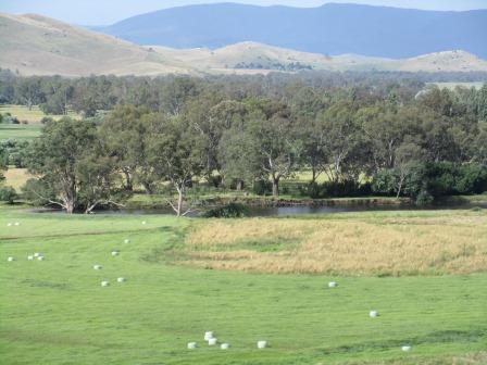
The
Mitta Mitta River winds back and forth as it travels through the flood plain.

Turn
off the Omeo Highway onto the Murray Valley Highway at 220m to cross the big
bridge over the River where it flows into the top reaches of Lake Hume.


The
river continues to wind its way into Lake Hume itself. You can see old bridge
supports below.


Stopped
at the Old Tallangatta township Lookout. The township was packed up and shifted
in 1956 as Lake Hume grew.

You
can see the raised area for the railway line in the middle of the paddock. The
old bridge we saw before was for the railway too. Some of the old houses are
still being used now.


Zoomed
in on the old Butter Factory.

Zoomed
to the left to where the Mitta Mitta River will wind its way to Lake Hume
proper.

The
railway.


Towong
Tourism has done a lovely job on the lookout.

Headed
off again – looking east towards Bullioh – you can see where the railway hugged
the edge of the hillside. The grass is drying off quickly in this dry hot wind
which has picked up a lot now.

Through
Bullioh, only a couple of houses, log cabins and working farm where you can
meet the horse whisperer and visit an Alpaca Farm. Another slow climb uphill. I
spotted an old bridge on the other side of the valley that is probably for the
railway – took a few attempts but I managed to get a photo.
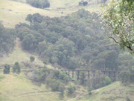
As we
were climbing we crossed a bridge (460m) which was over a cutting through the
mountain for the railway – missed that photo opportunity. Then another one at
490m obviously cutting back the other way. Climbed more to 560m into Mt Lawson
State Park. There was a dirt narrow road into the historical trestle bridge (I
think the one we saw across the valley before) so that will be on the ‘to do’
list later. Glad I have the blog to look back on when we return.
At
Koetong (600m) read a sign – Upper Murray Plantation 12,516 hectares of radiate
pine. Only a pub here which has folk music once a month and a New Guinea
artefacts gallery and winery.

Climbing
again to 770m where there is a ‘snow, ice and frost’ sign. Past the Tom
Mitchell Reserve for camping at Shelley – known for trains and timber. It
boasts having historically the highest railway station in Victoria. A big log
truck roars by.

Through
more and more pine plantations. The smell reminds us of Tinaroo and Tassie.

Saw
the turnoff to Lawrence Lookout, 2km down dirt road. Dropping steeply down now
through the pine trees with a strong cross wind blasting us – we travel with
the windows down as it isn’t hot enough for us to put on the air conditioning.
Down to 410m at Berringama into grazing land.

Then
into narrow valley following the Cudgewa Creek for a while.

Nice
flat rest area by the creek at 390m. Up again to 490m for a view over the
valley towards Colac Colac. Bit hazy today.

Back
to Colac Colac where we turned off a few days ago to head down to the source of
the Murray River – 574km round trip.
Into
Corryong. Steve dropped me off to get some groceries and he went down and
topped up with water and hosed the dust off the van. While I was waiting for
him by the Info Centre I found the plaque about the chap who swam the Murray
River in 138 days in1991-1992. Erica said his wetsuit is in the Museum.

Stopped
in the Wayside Stop out of town for a cuppa, 38 degrees in the van still. The
clouds are getting darker and the wind is feeding into them so we had better
find a campsite. Headed back to Towong (290m) and turned off to follow the
Murray River again – hiding under all the trees.

Up
to 310m at Farrans Lookout – also done by Towong Tourism – very nice. Great
photo of the Man from Snowy River – Jack Riley.


The
Alps and the Murray. Should have wiped the ‘deposit’ off!!


Mt
Elliot near Corryong.

Took
a video of the panoramic view then the still photos around.


The
Murray River in front of us then downstream as it winds its way through the
countryside.


Off
again through Tintaldra (280m) established in 1864 on one brochure and 1837 on
the sign as we drove in!! The Murray River near Clarkes Reserve another nice
camp area.

Pine
Mountain came into view – Australia’s largest monolith, 1.5 times bigger than
Ayres Rock. You can walk to the summit, 1062m, for fabulous view. Will wait till
my feet have recovered!!

Passed
a Minion letter box which was really good – I had my head down writing notes!!
Keeping
an eye on the Murray as we go along.

Through
Walwa (220m) known for its hospitality with golf course, resort, arts and
crafts and vineyard.

Back
into New South Wales as we cross over the Murray River into Jingellic.


We
can see the camping area upstream by the river.

Through
Jingellic village with a corner store, tree lined sports ground and a few
houses then around to the Bridge Hotel, est 1925.

The
camp area is below the hotel on the river edge (240m). Pulled up and went for a
walk to find a spot. One couple said that there is a 21st birthday
party here tomorrow night so suggested we find a spot at the other end. Got
one. Nice area but only one van has water views as we are in the hollow below
the pub.


Chatted
with our neighbours, Angela and Warren, from Brisbane. They are heading to
Tassie for 5 months so we got a drink and settled in for a chat. Lovely couple.
I gave Angela my camp book for her to take notes of where we stopped and then
downloaded my blog so they can check out info as they go.
I
wandered down to the river at 8pm to take a couple of photos.


I
missed a call from Kaylene – will ring her back later. Was a lovely warm night
so we left all the windows open and took off the bedspread again.
No comments:
Post a Comment