Another
lovely morning, 15 degrees. River is even lower this morning. At the other end
of the reserve a chap swam across to the other side and back yesterday
afternoon – bit chilly for us.


Packed
up and waved by to the bridge workers who had let us know when they were about
to start so we could get across first. Back into Victoria, through Towong and
Corryong then turned south at Colac Colac. Wound our way back and forth over
Nariel Creek.
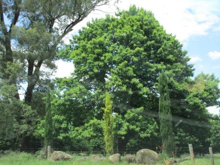
Nice
green pastures and a lovely home beside the old ramshackle one at Nariel which
is home to Australia’s first Folk Festival held in the Christmas/New Year
period


Passed
a farm with lots of tractors and missed getting a photo of his tractor
letterbox. Saw an emu and three chicks – now that is something we didn’t think
we would see down here.

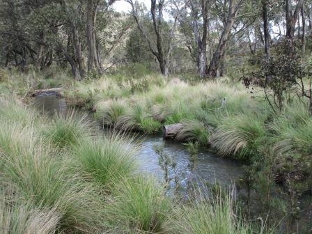
Stopped
at Stacey’s Bridge Campground for a cuppa (530m elevation). Wheelers Creek
flowing well. Even spotted a couple of trout.


Information
about the fires that tore through the Alpine and Kosciusko National Parks in
2003. One thing good from the fires has been they have found a lot of
historical mines and aboriginal artefacts etc.


From
here it is dirt though the lady at the Info Centre said her husband had spent
years widening it so off we went.

Glad
we have a better detailed map as we have lost all the maps off the VMS when the
chap in Tassie reset it – will have to buy a new one. It is nice and wide and
we slowly climbed up the hillside. Two motorbikes came past but that was all
till we reached 1100m elevation over the Nariel Valley – but no vantage points
here for a photo. Went down a bit then climbed again to 1200m and stopped at
Lookout. Unfortunately the trees need pruning but the view is to Mt Bogong
(50km away) which has an elevation of 1986m and to Dartmouth Dam (25km away)
which has a full supply level of 486metres. Mt Bogong is Victoria’s highest mountain.


The
road has been good.

Up
to 1300m into the Alpine National Park and passed a sign that said ‘Highest
point on road, 1342m’. On the east side of the road is the Pinnibar Pendergast
State Forest. Turned left at Sassafras Gap (1295m) into the State Forest. Lots
of tall dead trees but heaps of new growth coming up.

Winding
down beside Sassafras Creek to 760m then turned away from the creek which flows
into Gibbo River. Back into the Alpine National Park as we travel down beside
the Gibbo River. Lots of big skinks on the road that Steve is trying to avoid.

Across
the bridge over Gibbo River at 580m elevation. It flows down into Dartmouth
Dam.


Down
onto Kings Flat at 550m – open area with accommodation house that had ‘no
vacancies’ at the moment.
Continued
along beside the river.

Passed
a dead snake, then Steve ran over one and it went bang then he had enough time
to see this one and miss it. I got a photo though.

Down
to 520m as we leave the river to climb up again to 630m. Not sure what this tree is but there are
heaps in an orchard here.
Onto
open pastures with cattle and sheep.

Crossed
the Australian Alps Walking Track. Climbed up to 680m along the hillside with
the Morass Creek below us in the valley.
Across
Deep Creek bridge (which wasn’t deep at all) at 630m and onto bitumen again. It
was a very good dirt road. Lovely countryside with The Brothers in the distance
which is in Brothers State Forest.


Into
Benambra (700m) which has one of the highest ovals in Victoria (over 700m). Had
lunch near the Community Owned General Store. The Omeo and Benambra district was one of the
first areas of permanent settlement in Victoria. Graziers came overland from
the Monaro Plains in NSW in about 1835 to establish squatting runs. Info on the
Australian Alps Walking Track.

We
are on the edge of the Great Dividing Range which we will go over to get to our
campsite at Native Dog Flat in the Alpine National Park.


Headed
off again – Mt McFarlane in the distance which has a lookout on top. Might be a
bit of a walk though.


Stopped
at a cairn on the site of Omeo Station, established in 1835. Unfortunately the
information and photos on the notice board have fallen off.

Back
on the dirt again and climbing up to 960m.

Up
and down the hills to 1050m past grazing land then into Limestone State Forest.
Climbing some more to 1300m at Nunniong Road intersection which is the border
between Tambo State Forest and Alpine National Park.
Into
the Alpine National Park and down steeply to cross Limestone Creek (1000m). A
grader has been over the road. Actually he is still on it. Heard him say to the
water truck guy – ‘hey there is a caravan behind me’. We called up and said we
were ok and not in a rush but he said he would pull over and let us pass.
Thanked them - They only do it once a year so we have a good road at least.

They
were still working on the next few kilometres so we had to dodge the rocks in
the middle.

Climbing
steeply again to 1150m to Limestone Creek Track where there is another campsite
down by the creek but it is a steep drive down – not recommended for caravans.
Up to 1300m at the turn off to the track to Cowombat Flats where we will hike
to tomorrow. A group of younger people were just getting into a troopcarrier –
gave them a wave and one yelled out ‘we have been hiking for 8 days’. Ouch.
Down
the hill again to cross the Buchan River (pronounced Bucken) and into the camp
area (1200m).

We
are now on the other side of the Great Dividing Range so it flows the other way
heading south. There was another group of tents and a few cars but no people.

Chose
our spot. Past us was a fenced off area that said ‘dog fence’ – we thought it
was the horse enclosure as the next area down is called the ‘horse camp’.

Put
on a jumper as it is a lot cooler up here. Had a cuppa then went back to the
turnoff to Cowombat Track to check it out. There is a gate at the start of the
road that is closed for winter (the first Thursday after Queens Birthday
holiday and opens again on the first Thursday after Melbourne Cup). Through
that for 4km till the next gate that doesn’t open. This is where we have to
walk from. Lovely gums.

This
explains the fenced area – it is so they can see what grows if the brumbies
weren’t here eating things.

We
will be following the Australian Alps Walking Track till we reach the Murray
River, then we have to explore ourselves to find the source. At least this part
of the track is a road and is wide and clear to follow.


Back
to the camp where we checked out the info board near the river (well it only
looks like a babbling brook really).


Drove
down to the Horse Camp to check it out. There was a couple there so stopped for
a chat. Jenny and Warren have been travelling for a while living out of their
Nissan Patrol wagon. They can go anywhere and love it. Had a great chat. Gave
them some wood we collected and we will come back for drink with them.
Cute
little Flame Robin likes our aerial. They are so cute and zip around catching
bugs. Wish they would catch all this annoying bush flies!!

I
can just see the top of Rams Head from our camp (1621m elevation).


Put
on some warmer clothes and went back over to Jenny and Warren for a lovely afternoon
of chatting. They bought a ‘fix-er-upper’ heritage house in Oatlands and have
been doing it up over the years. Now they rent it out for tourist accommodation
– I am sure I took a photo of it. Lots of rabbits running around. Heard the
whinny of some brumbies but haven’t seen one yet – just lots and lots of poo.
While
I got tea ready Steve went over to say hi to the guys in the other camp who had
come back. They are here working – cutting out Willow trees. They were an
introduced species and they suck up too much water so Gippsland Water has hired
them to kill the trees. They have to walk up the creeks and in the creeks
removing them and poisoning the trunks. Must be good money!!
Lovely
night though the temperature is dropping. Clear sky with lots of stars but I
won’t be star gazing tonight!! 9.30pm it was 11 degrees – and I had packed the
winter woollies away!!
No comments:
Post a Comment