Lovely
morning. Great view out my window with the sun glistening on the river, though
it is only 17 degrees in the van.
Took
photos of the brochures of the Murray River and some information out of the
booklet Erica gave us.


Headed
over the bridge into Victoria then down a dirt road for 6km to join the Murray
Valley Highway. Across the Murray River again on the Bringenbrong Bridge back
into NSW. Glad there are no border inspections between NSW & Vic.


Onto
the Alpine way - lovely countryside.

Turned
on the Spillway Road and drove over the earth dam wall to the spillway and
outlets of the Khancoban Dam (370m elevation).


On
the other side of the dam wall was an airstrip.

Information
about the Snowy Hydro Scheme etc.


The
water was flowing out fast down into the Swampy Plains River.


It
was being sucked in through here.

Walked
up the road for a view back.


The
motors to raise the gates.

Only
one ski boat on the Dam so far.

Looking
over the water which is called a Pondage, to the pipes that bring the water
down to the Murray 2 Power Station at the other end of the Pondage.

Climbing
up the Alpine Way.

A
group of older sports cars going for a cruise.

The
many power lines strung across the valley.

I
saw a dam wall but it isn’t on my map. Further up is the Murray 1 Power Station
so it is to do with that.

The
pipes that head down to the Murray 1 Power Station.

Further
around we stopped at the Lookout overlooking the power station (630m
elevation). They have tours at 11am and 2pm so will try and get back for the
later one. Not that we have learnt all about power stations in Tasmania.


Climbing
up the narrow road to Scammell’s Lookout (990m). Chatted with a chap with his kayak
in the back of his ute. He said they normally go down the river in September
but they didn’t get enough rainfall. The area had about 40mm the last couple of
days so the river is flowing well.

Fabulous
view on the sign – shame we have a few too many clouds hanging on the mountains
today.


We
can see Mt Sentinel clearly though.

A
group of motorbikes zoomed in – Road Hog brigade!! We headed back down onto the
road again. Next section very narrow – we brought Lou’s first motorhome through
here though in 2003.

Steeply
down now to Geehi Flats (440m) and across the bridge over Swampy Plains River
which flows down in the Khancoban Dam/Pondage.


Now
we are following cyclists – note, when we come back don’t drive up on the
weekend, especially if we bring the van in. Back up to 810m and then down again
to 540m at Tom Groggin Camping Ground. We stopped here with the boys in 2003
and watched the Man from Snowy River on DVD – well I enjoyed it!! Found the
photo we took back then.

Lots
of kangaroos hopping and lazing around the area.

Down
to the Murray River for another selfie.


Steve
skipping stones – didn’t get too many skips!!

Around
the campground which is huge – bubby wants a drink then looked like he was
going to try and get back in.


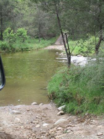
Drove
further upstream to be at the closest we could get to the source of the Murray
River until we can drive to it. Too deep and fast to cross here at the moment. The
planned walking track on the map hasn’t been done yet. Chatted with a chap
there and he has been to the source from Omeo end. Showed us a nice camp area
where brumbies run wild but he said it is 12km hike in to the source. Oh well
that’s what we have hiking boots for!!


Walked
down a bit to look across to where the road goes up on the Victorian side. They
even have a big sign over there.


Back
to Tom Groggin for lunch by the river, watching a couple of ladies try and
fish.

Headed
back then turned off to check out the Tom Groggin Horse Camp – provided as the
Bi-Centennial Horse trail travels along the river.

Back
on the Alpine Way and looking down over Tom Groggin Station which is in
Victoria.


Next
stop was down Grassy Flats Track to the Murray River. Only a small camping area
and the road down was steep and bumpy – no van in here.

Further
along we turned off at 690m elevation and followed the Murray Gates Track down.
Again a narrow rough road then across a little creek.

Lots of bracken fern as we head down to the river again, deep in the valley. On the map it shows further downstream and spot called Murray Gates – might be white water area as it says further on is Hermit Creek Rapids. Two spots – one for a camp and the other is just a circle drive to the toilet. No track down to the water so obviously this area is not used much.


You
can just see through to the Murray River.


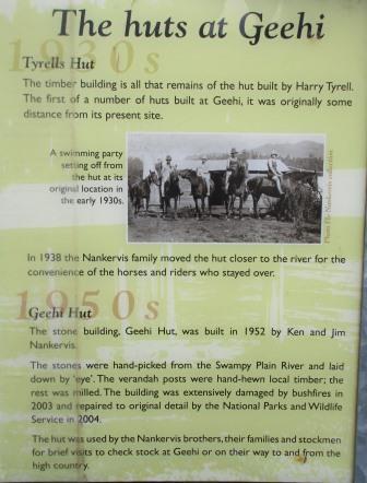
Back
up the track to Geehi Flats Camping Area. Lots of roomy sites beside the Swampy
Plains River. A few old Huts have been saved. Great information boards.


Nearby
was a sign about the Western Fall but I had to walk out into the paddock to see
them as the trees have grown up around the sign and you can’t see the
mountains!!


The
Swampy Plains River makes its way down through those mountains.

Went
over to check out Geehi Hut, handmade out of river stones, right on the edge of
the river.


The
kayak chap was chatted to was making his way down the river. He has left his
pushbike downstream then he will ride back to his ute then drive back to pick
up his kayak – fit bugger!!

Steve
likes the fancy fireplaces here. They even mark North in case you get lost!!


Upstream
a bit is a ford to cross to Behrs Flats - other camp sites and old huts.
Wildlife
boards – they don’t have the red parrot on it.


A
small viewing platform beside the river.

More
information in the Day Area.


Back
on the main road then we turned off onto a narrow dirt road to check out
Olsen’s Lookout. The road also leads on to Geehi Dam but that part of the road
is closed so Snowy Hydro can carry out repairs. Lots of lovely bright green
tree ferns line the road and up the hillsides.

As
we climb the snow gums multiply.

Up
to 1000m at Olsen’s Lookout. Spectacular view and the clouds have moved away so
we can see all the mountain tops.


Watsons
Crags. Zoomed in closer to see all the rocks.


Mt
Anderson.


We
saw Mt Sentinel from Scammell’s Lookout.


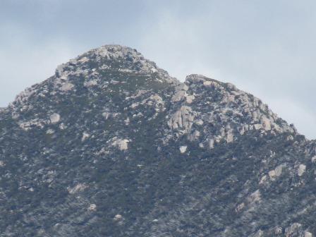
Carruthers
Peak.


Mt
Townsend and Abbot Peak.


Water
flowing down the mountainside heading to the Geehi River down in the valley.
The river sounds like it is flowing well. It flows down into the Swampy Plains
River.

Heading
back out and we heard someone call they were heading up the road with a bus and
two cars – it was the ranger with Snowy Hydro people but we passed ok on the
narrow road.
Back
on Alpine Way and on to the power station. It said it closes at 4pm and we got
there just before so we could have a quick look.


The
lady in the kiosk said that if we didn’t go back out quickly the gate which is
automated will close at 4pm. We got back up there at 4.05 just as it started to
close. Headed back to the kiosk to wait until she had finished closing up. She
let us wander around the exhibit while we waited.


7
July 1949 - Commonwealth Parliament passes the Snowy Mountains Hydro-electric
Power Act 1949 which established the Snowy Mountains Hydro-electric Authority
(SMHEA), the construction body for the Snowy Scheme, with William Hudson (later
Sir William Hudson) selected as the first Commissioner to head up the ambitious
development.
17
Oct 1949 - Construction started on the Snowy Scheme with Governor General, Sir
William McKell, firing the first blast of dynamite near Adaminaby.
November
1951 - Construction of the Scheme’s first power station at Guthega commences.
1954
- Cabramurra, Australia’s highest township, was established.

23
April 1955 - Guthega Power Station official opening, Prime Minster Menzies was
on hand to turn the switch to produce the Scheme’s first power.
May
1955 - Construction of Tumut 1 Power Station commences.
May
1956 - Eucumbene Dam commences.
1956-1957
- The township of Adaminaby is relocated to make way for the rising waters of
Lake Eucumbene. The first house relocation took place in 1956 and within 18
months all the 102 buildings to be relocated had been relocated.

1958
- Eucumbene Dam construction is completed. It is 9 times the size of Sydney
Harbour and the central dam of the Snowy Mountain Scheme.
June
1958 - Construction of Tumut 2 Power Station commences.
December
1959 - Sir William Hudson made wearing seatbelts in SMHEA vehicles compulsory,
a decade before the rest of Australia.
29
August 1960 - Snocom delivered to Cooma. Somcom was Australia’s first
transistorised computer and one of the first dozen or so in the world. Used
until 1967 for engineering design calculations for the Scheme, the SMHEA was a
leader in its field in the use of computer technology on a project of this
kind.
December
1962 - Construction of Murray 1 Power Station commences.
March
1963 - Queen Elizabeth 11 and the Duke of Edinburgh visit the Snowy Mountains
Scheme.
19
December 1964 - The township of New Jindabyne was opened by Sir Eric Woodward,
Governor of NSW, after being relocated to make way for Lake Jindabyne.
1966
- Construction of Murray 2 Power Station, Jindabyne Pumping Station and
Blowering Power Station commenced.
July
1968 - Construction of Tumut 3 Power Station commences.

21
October 1972 - Official opening of Tumut 3 Project, marking completion of the
works on the Snowy Scheme.

August
1974 - The Scheme is now fully operational. Tumut 3 is the largest power
station within the Scheme.
13
December 1998 The National Electricity Market (NEM) commences creating the
Australian wholesale electricity market connecting the states of Qld, NSW, Vic
& SA. With the end to end distance of more than 4000 kilometres, the NEM
operates one of the world’s longest
interconnected power systems.
Murray
1 Power Station generates electricity from the waters diverted through the
Murray 1 pressure tunnel from Geehi Reservoir. The power station comprises of
10 units which can each produce up to 95 MW of power. Each unit is capable of
powering 95,000 average size homes. The water travels to Murray 2 Dam which
provides the head pondage for Murray 2 Power Station. (That is the Dam we saw
in this valley.) Water is released out of the Snowy Mountains Scheme from
Khancoban Pondage into the Swampy Plains River, which then flows into the
Murray River.


A
model of the Snowy Mountains.

Some
of the photos.


Interesting
info about cloud seeding.

Boving
generator.


There
was another display showing the Geehi Dam (the one we couldn’t get to) and how
the water is sucked down in the pipes underground, but the photo didn’t come
out. It said - 7 miles x 21 ft diameter
Murray 1 pressure tunnel carrying water to Murray 1 Power Station.
Fabulous
aerial photo of another Power Station.

Back
outside to the pondage – no power being generated today.


Walked
down to the end where the pond goes around and down the valley to the dam wall
we had seen earlier.

Humes
Limited received a Construction Achievement Award in 1968 for building the pressure pipelines.

At
last she finished in the kiosk so we headed back up the road to the locked
gate, she opened it with a swipe card and off we went. It was nice that she let
us wander around anycase. Looking down the valley where the creek would
normally follow if it wasn’t stopped in the dam and diverted through and down
the mountain to Murray 2 Power Station at Khancoban.

Down
the bottom and we turned off the main road toward the power station and the
boat ramp. Past the Murray Upper Control Centre.


The
power station is not open for public but the boat ramp was.


Looking
back up to where the pipes come out of the mountain then drop down to the power
station.

Followed
the road to ‘viewing area’ and found where the water ends up at the Murray 2
Power Station.


Looking
back to Khancoban village.

Stopped
off a Khancoban to check out the roses and the lovely trees.


We
had missed a call from Jon when we didn’t have good reception so rang him back.
The poor thing had been stung by a stinging tree at Crystal Cascades. We said
put some sticky plaster on it and ring Nana. Hopefully he will be ok. My
cousin, Judy, was stung there when we were young – it wasn’t a nice experience
for her.
Crossing
over the Murray again to head back into Victoria. On the left is where the
Swampy Plains River meets the Murray River.


Back
along the dirt road where the houses have the best view – the clouds are
getting darker over Kosciuszko National Park. Looks like snow on the top but it
is the tops of the trees that are stripped of leaves.


Back
into NSW and to our van.

The
water had dropped about 6 inches as we can now see the rocks more clearly.

Sitting
by the river listening to all the birds and the gentle sound of the river
rushing by. The kookaburras are singing their sunset song then all of a sudden
all the birds are quiet and then the crickets start. Waiting for Mr Platypus to
come by again. Bush cooker dinner tonight
- such a lovely spot.

No comments:
Post a Comment