No
wind this morning, still cloudy but the sun is peeking through. The inlet looks
so calm.

The
water appears to be dropping or maybe it is just low tide as more rocky bars
are appearing. The cars are back on the point. Frank said some people were
surfing the wave rolling into the inlet.


So
nice this morning we had our cup of tea outside enjoying the view. The birds
were happy singing and the flies/march flies were busy buzzing around – sounded
like a Grand Prix with all the zooming around us.
Packed
up and headed back up the dirt road – water still across the road. Onto the
bitumen for a bit towards Bremer Bay then we turned north to Gairdner then
headed east towards the Fitzgerald River National Park. Stopped for a cuppa at
the National Park info area.

Then
onto corrugated dirt road through the park to Point Ann and St Mary Inlet.
Turned into the campground just back from the beach and found a perfect spot.
Nice flat spot and we can see the sea from inside the van which is lovely.
Further along the beach are more hills in the national park. From the NP
brochure - The park covers an area of 297,244 hectares. It is one of the largest
and most botanically significant national parks in Australia, with
approximately 15 per cent of the State’s described plant species growing amid
the magnificent landscapes. So far, 1883 plant species have been identified, 75
of which are found nowhere else. More species of animals live here than any
other reserve in SW Aust. They include 22 mammal species, 41 reptile species
and 12 frog species. There are also more than 200 bird species including rare
species such as the western ground parrot, the western bristle bird and the
western whipbird.
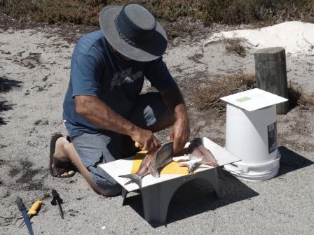
Two
men pulled in and gave Steve an Australian Salmon as they had caught too many
to eat this morning. So Steve got to filleting it so we could have fish for
lunch.

Walked
down to the beach to feed the fish carcass etc to the birds. We are in Point
Charles Bay – the point being further along the beach under the mountains, with
Point Ann to our right.


Further
along the beach to where St Marys Inlet entrance is. It is fed by the St Marys River. Very wide area. The water
is a long way back from the ocean so would need some good rain to get it to the
ocean again. Steve tasted the water and it was very salty – much more than the
salt content of the ocean. In the distance is Poorijumgup (Mt Bland) that we
passed coming here.


Lovely
and clear though. Looking back towards the beach.


Enjoyed
our lunch of fish and salad then headed back along the road to Quaalup
Homestead, an outstation for the Wellstead family of Bremer Bay. Queelup (West
Mount Barren, 372m) and Poorijungup (Mt Bland, 258m) stand out from the low
scrubland.

Quaalup
Homestead is now a wildlife retreat and has some accommodation and room for
vans and camping. The homestead is open for day visitors to look at with a
request for donations to replace the roof. The old barn built in 1858 has seen
better days.

Looking
back to Queelup (West Mount Barren) which has a walk up to the summit, 1.7km
return (allow 2 hours) but it is straight up!!

Lovely
looking building.


The
history of the homestead and area.

Wandered
around inside.


Lots
of old photos.


Steve
found an old magazine on the table, printed on his birthday but four years
before he was born. Now that’s old!!

Interesting
plant.


Continued
down the track past a couple of other houses – one with a very serious fence,
not sure if it is to keep animals in or pest out as there is some serious wire
on the fence.
Across
a causeway over the Gairdner River.


Followed
the track for a bit, a few more houses hidden in the bush then decided to turn
around as there were lots of different tracks heading back towards Bremer Bay
or down to Gordon Inlet near the coast.
Back
past the homestead where there was a lot of these unusual looking plants
everywhere. They are called Royal hakea (Hakea victoria).


Also
lots of banksias.


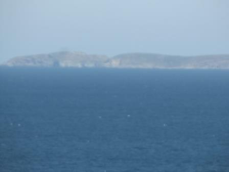
Headed
back to camp then turned down the 4WD track to Trigelow Beach. Hazy view across
Doubtful Island Bay to Doubtful Islands – the site of WA’s first whaling
station 1836 to 1867. Every winter small wooden boats would leave the sheltered
bays of Doubtful Island to hunt both humpback and southern right whales. Now
the island is a nature reserve.


Tooragullup
Beach on the other side of this bay.

Conveyor
belt protects the hillside dunes from the vehicle traffic though the beach side
the track is solid.


Soft
sand on the beach though so more air out of the tyres.

Another
long beach with clear blue water. Can’t spot any fish though. Found a couple of
pretty shells then had a cuppa watching the waves.


Nearly
back at camp – on the high ridge above Point Ann lookout. Top view.


Drove
down onto the beach and right along to the rocky headland then up onto the
headland and along the top through the scrub (more bush pin-striping for the
truck). Stopped at the top – looking left towards Point Charles, the rocky
headland, then down the beach to Point Ann.


Passed
some people doing the walk to Point Charles then onto to Fitzgerald River
Inlet, called the Mamang Walk Trail, approx 31km return – good on them!!
Turned
back – Steve trying to spot good gutters to catch some fish. Back to camp and
we grabbed a drink and our chairs and joined the two chaps who gave us the
salmon. Got the low down of where to fish etc. They are volunteer fire-fighters
from Nannup so we heard all about all the fires etc.
The
wind has picked up though we are protected here with the low scrub. Nice to see
some stars out though it is still a bit chilly.
No comments:
Post a Comment