7.30am
18 degrees. No wind this morning but overcast. The inlet is so still.

9am
headed into Bremer Bay to explore. The clouds are parting so hopefully the day
will improve.
Drove
through the little township to Millers Point, a boat ramp into Wellstead
Estuary. Looking up the estuary to where the Bremer River flows in.

Forlorn
tree.

On
the other side of the point is another boat ramp. Looking down towards the
mouth where it flows into Bremer Bay.


Drove
back along the estuary edge to a jetty.

Zoomed
in on the sandbar across the estuary’s entrance to the bay.


Back
to the Info Centre to pick up the Point Henry Drive Trail brochure and read the
information about the history of Bremer Bay. Good aerial of the bay and
estuary.


Drove
out to the sandbar – on the map it says Gairdner Road goes across the sandbar
and continues across the other side. The sand is very hard here so Steve
reckons it is ok to cross the little channel – but we didn’t.

Parked
beside the channel joining the estuary to the bay. Zoomed in on the houses
beside the estuary.

The
water was rushing in and out with little fish swimming in front of the wave.


Around
Bremer Point to the Southern Ocean.

Zoomed
in on sand dunes across the bay above James Cove.

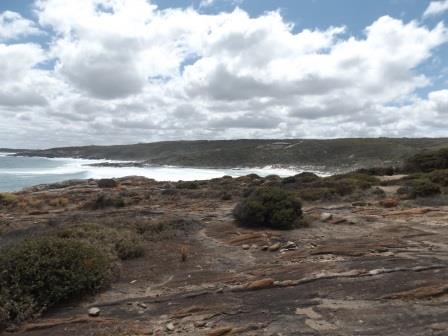
Bremer
Beach – not looking to bright and sparkly today.

Drove
back then up the hill to the lookout over the estuary and bay and info about
whales and seals.


Made
a cuppa and enjoyed the view. A tour bus with only one passenger pulled up. The
guide said the Cheynes at Cape Riche are the same family of the Cheynes with
the whaling boats etc.


Across
the bay West Mt Barren (340m) and Mt Bland (320m) tower in the Fitzgerald River
National Park.

Out
to Bremer Point where the Wellsteads had a signal cairn to let ships know when
to come in for cargo etc.


Some
dolphins were rounding up fish in the distance in John Cove. I managed to get
some fins and even some dolphins in this picture.


The
point looking out to sea. Zoomed in on an island but no mention of its name on
the map.


John
Cove and beach that continues around to Back Beach (abalone farm) then Fishery
Beach where a boat harbour is.


Looking
back over Bremer Bay. No name for the point.


Back
into town to the 1896 Telegraph Station. It is now a café/restaurant so we
didn’t go in. Construction of the Overland Telegraph Line from Albany to
Adelaide began in 1875 when the original station was built. It opened for
telegraphic traffic on the 8th May, 1876. The original building
burnt down and was replaced with this stone structure in 1896.

Continued
down Wellstead Road to the original homestead and other buildings at Peppermint
Grove on the western side of the peninsula. It is still owned by a descendant
of the family and there is a museum, coffee shop etc but unfortunately today it
is closed.


The
first cottage along the road though is John’s Cottage – the first one he built
when he first came here in 1850.

Back
to Point Henry Road then down Swarbrick Road to Fisher Beach on the other side
of the point. A boat harbour has been made here but originally there was whale
tryworks here in the early days then it was used as a base for salmon and
herring fishing. I wonder if the Swarbricks were related to the family at
Walpole. Walked down and found concrete slabs in the creek area off to the
right so not sure if that was the tryworks or the salmon tanks.


Back
up to the main road then onto Black Rock Road and up to Tooreburrup Hill’s
Lookout. Great view. Obviously the Wellstead family has sold off all the land
they had on the peninsula to housing now. Starting from over Point Gordon then
around to Point Henry then the point above Little Boat Harbour (the first
beach).


Across
Dillon Bay to Cape Knob then around to Stream Beach and Dillon Beach.


Across
the other side are the info board and a big rock that I climbed up on to get a
better view over the farmlands. In the distance we can just make out the
eastern end of the Stirling Ranges but it didn’t come out in the photo.


Across
the estuary to the two mountains in the National Park. They only have one wind
turbine on Windy Hill.

Over
Bremer Point and Bremer Bay – across the other side is James Cove and
Peppermint Beach.


Back
to Black Rock Road then further west to the site of two of the Wellstead
children’s graves. The homestead is only a short distance north but we had to
do the long drive around as there is a big sand dune in between.


The
rest of the family must be buried in the family plot in Albany.
Back
to the main road and then east to Short Beach for lunch. A few people were
trying to catch their lunch but with no luck. Found a cute little gecko in the
toilet.


A
few houses are nestled into the scrub.


The
original shack was located just above the carpark.


Back
up to the main road then continued south and then west to Blossoms Beach.

Looking
across Dillon Bay – on the map it shows a Mt Remarkable – might be the sand
dune one.


Another
dune behind us that is well used by the looks of the tyre tracks.

Back
up the sandy track to the main track where we found the info board at the
lookout. Amazing to think of dairying down here.


Zoomed
in on Cape Knob on the other side of Dillon Bay.

Further
around the point to Native Dog Beach on the east side. Both are good surfing
beaches.

Info
board about the dingoes.

More
homes on the hill side – grand new ones and one that looks old.


The
view from the platform – wild waves crashing onto the rocks.


Walked
out onto the rocky point between the two beaches. Stood watching the waves roll
in from the Southern Ocean.


Back
up to Point Henry Road then east to Point Gordon which juts eastward above
Point Henry. The road only went a little way out to the point past more homes
in the bush then turned down to turn around in the bush. I saw a track with a
cliff safety sign so went down to check it out.

Fabulous
view from the top of the cliff east to Point Gordon and down to Banky Beach. A
steep descent down to the beach though people must go down as there is rope halfway
down to assist the descent and ascent. Steve went out further where someone had
put a seat!!


Across
the point is Point Henry.

They
certainly have a spectacular view.

Headed
back through the trees to the truck.

Back
to Point Henry Road to the end of the bitumen then we turned west down to
Little Boat Harbour. Only a small car park area though they provide more
parking areas up the hill. Two couples were fishing – one chap had a small
whiting and a good sized herring.


Looking
across to the track we took down to Blossoms Beach and the tower on Tooreburrup
Hill.

Steve
found me a little abalone shell.

Back
up to the top then down the 4WD track to Point Henry on the east side of the
peninsula. There are tracks going off to both sides – obviously locals’ good
fishing spots. Some spots were very narrow as the scrub is growing back well –
some more bush pin-striping for our truck.


The
last bit was more eaten out so I decided we should pull up and walk the rest of
the way!!
Steve
backed up into the bush and a beautiful peppermint smell greeted us – hence the
Wellstead’s called their place Peppermint Grove.

As
we headed down I snapped away – Across the other edge of Bremer Bay to Hood
Point with Doubtful Islands behind (where the first whaling station was).


Looking
back over the bay to Banky Beach and Point Gordon.


At
the end there was a memorial to a chap.


Big
rocky area.


We
walked down as it wasn’t steep and not too windy. Steve found an interesting
‘shell’ – I had taken the top off my thumb cutting onions last night!!

Walked
along, there is a good flat platform that you could fish from but we didn’t
bother going down to it. Further around the rocks got steeper.


The
recent rain has left little pools everywhere.

Back
up the track then turned to the south west to another lookout area. Sparkling
Island wasn’t as sparkly as the sun shining on the water.


On
the other side looking back at the rocks that go around to Point Henry.


Back
along the 4WD track to the bitumen. Done enough bush bashing today.

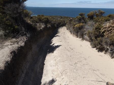
Headed
back then nearly back to Bremer we turned east again down While Trail Road to
the abalone farm at Back Beach. Lots of pipes going from the farm into the bay.


Read
the info about the seadragon then drove down onto the beach, which was very
soft sand. Got bogged as Steve hadn’t let any air out of the tyres. I wandered
with the camera while he got sorted.
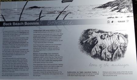

The
Bommie which is home for the seadragons.

Further
out is an island with a marker but no info about it. I zoomed in on it back off
the first lookout at Bremer Point.


Lovely
beach so we parked and made a cuppa and enjoyed the view and sunshine.

Headed
home after pumping up the tyres again at the service station. As we passed the
cleared timber plantation I spotted a herd of emus. When we pulled up though
they ran off in the other direction.
Turned
onto Miller Point Road and we saw a rabbit run across the road then a goanna
had a slow wander across it.
Went
for a wander around camp and chatted with a couple who have come from
Esperance. They gave me names of good places to stay and things to see which is
handy. They are going on the cruise tomorrow out to the Bremer Trench to
hopefully see some Killer Whales etc. It is $385 each though they got pensioner
rate of $350 so I hope they see heaps and that the weather is better for them.
I googled the info and got this photo – that will do us.

Frank,
camp host returned and came by. He said it was amazing watching the river swell
then break through the sand bar and flow into the ocean. There were big trees
etc whizzing down the river and out to sea.
Back
to the van for a drink then I saw the lovely golden glow across the inlet on
the cliff face. Turned around and saw the sun behind the pine tree as it headed
down behind the hills. The clouds are back again.


No comments:
Post a Comment