Overcast
morning – weather forecast for heavy rain tomorrow so we decided to head off to
see if we can find some King George Whiting according to the fishing guides.

Chatted
with Anna about the weather forecast of heavy rain tomorrow. They needed more
drinking water so we offered to take a 20 litre drum of theirs to fill up. We
had a 10 litre drinking water under the bead that we got before the goldfields
so got that out for them as we have heaps. Steve had pumped across the water in
the truck to top up the van and we will top up the truck in town too. Headed
back to the main road then down a dirt road to Nanarup past Taylor Inlet which
is blocked off from the ocean.


Walked
out onto the beach though the wind was blowing us backwards and it was
freezing. Looking east around to Mt Gardner and Cape Vancouver then Rock
Dundar.


Then
across to Breaksea Island (you can see the lighthouse) and Islet Point a rocky
outcrop at the end of the beach then around to the inlet.


The
wind blew us back to the tree sheltered picnic area for a hot cuppa. Won’t be
fishing here.

Back
up the road then we turned down to Ledge Point. A 4WD track lead off across the
Gull Rock National Park and another 4WD track down to Skippy Reef Beach but we
skipped that. Out to the point with a view over Skippy Reef Beach and Herald
Point.


Straight
out across the North Channel was Michaelmas Island.

Then
over the point to Flinders Peninsula on the other side of King George Sound.

Walked
to the west side of the carpark to look to Mt Adelaide with ships waiting to
load up at the wharves.

View
down to Ledge Beach with Mt Martin behind.


Drove
back a bit then stopped for a walk down stairs to the east end of Ledge Beach.
Nice view – a wrecked boiler, hence this spot is called Boiler Bay.


Scanned
around. It is nice and calm here but we can’t see any sign of fish. Would be
lovely on a hot summer’s day – oh yeah it is summer, shame we are in jeans and
jumpers!!


Zoomed
in on the entrance into Princess Royal Harbour and Mt Adelaide – you can make
out the wind farm on the other side of the harbour.


Drove
around to the other road down to the western side of the beach. Looking across
to Ledge Point and Michaelmas Island then to Flinders Peninsula over King
George Sound.


Gull
Rock with Michaelmas behind.


Zoomed
in on Whale World in Frenchman’s Bay then Bald Head on the end of Flinders
Peninsula.


There
is a walk to do over Mt Martin to the other side and Oyster Bay – but we will
skip that today!!


Back
up along the east side of Oyster Harbour (though there is no access down to it
from this side) and across the Kalgan River which flows into Oyster Harbour.


Stopped
west side of the King River to top up with water from a tap in the park. I
walked down to the river which also flows into Oyster Harbour.


Zoomed
down to Mt Martin on left and Emu Point on right with Middleton Beach and its
pine trees in the middle.

Then
back up the other side of Oyster Harbour.


Lots
of birds to look out for.


Steve
was helping another chap with his water when I got back.

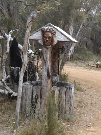
Headed
down to Emu Point. I had marked the map about chainsaw sculptures so we turned
onto Mercer Road and found it easily. Another car had just turned in so we
followed. Stopped first to take pictures of all the ones at the entrance. Loved
the spider – reminded me of the one in Harry Potter.


The
sign said ‘Sculpture Drive’ so we continued on then another sign said ‘stay in
car – dangerous animals about’ with the truck nearby.

A
bit of farm machinery sculpture too.

Then
it was just chainsaw carving after another – there were so many that I started
being selective – well sort of!!


As
we came around to the house there were so many smaller ones and other bits and
pieces.


Made
a donation as it is amazing.

In
the shed next to the house I saw the chap getting ready to start a new
sculpture on some more tree trunks.

Still
more as we headed back out.


Down
to Emu Point which was lovely even though it is overcast, windy and cold.
Scanned around Oyster Harbour then down the channel to Middleton Bay.


Zoomed
in on the ships in King George Sound.

Then
Mt Adelaide and the Convoy Tower in front of the repeater tower.


Zoomed
back up Oyster Harbour to Green Island.

Had
our lunch with the seagulls on a bench in the park trying to get out of the
wind. Steve said we should have had hot chips rather than our cold salad!!
Followed
the road along the waterfront around the caravan park – one that is actually
down by the water. Saw another chainsaw carving and found out it and the others
we saw were done by Darrel Radcliffe, as he didn’t have his name back at his
house.


Headed
back up and around Oyster Harbour and across to Two Peoples Bay Nature Reserve.
Passed two lakes, one with big sand dunes. The Reserve is a pay to enter one.
There are heaps of carparks and an Info Centre so I went in for a look. It is
unmanned but has lots of information and a table full of bits and pieces to
touch.


Found
the explanation to its unusual name.

As
we had read at Norman’s Beach this area is all about saving the Noisy
Scrub-bird and Gilbert’s Potoroo. There were buttons to press to hear the
bird’s call and people talking about saving them. Very well set up display and
free though there is a donation box of course. Back down the road was the
research centre.


Drove
down to the picnic and boat launch areas.


We
are on the other side of the bay from the campground down at East Bay.

Looking
across to Mt Manypeaks pass North Point then around to South Point.


Decided
it was too cold to think about fishing today. Back to the Info Centre then
south to Little Beach on the other side of South Point. What a pretty spot.
This is the bright white beach we see on South Point as we climb up the hill
from Betty’s Beach.

Walked
out onto the big boulders looking across to North Point. Great spot to fish
from if we weren’t freezing.


Then
over the beach, the hill is Mt Gardner which is also the name of the lake on
the other side.


Continued
around over the big flat rocks.


Back
on the road – stopped for a photo of Gardner Lake with Mt Gardner in the
distance.

Tried
to follow a shortcut road on our map back to Betty’s Beach but it has been
blocked off. These lakes provide drinking water.

Continued
back up the hill then I got a shot of Moates Lake and its sand dunes.

Got
to the start of the Nature Reserve and Steve found a dirt track to follow –
determined to find a short cut back. Well it did cut a little off the drive
though it was slower over the sandy bits than on the main dirt road but he had
fun.
Back
to camp. Stopped at Anna & Jeff’s to drop off the water. She said we missed
all the excitement. A police car came down showing a photo of a chap that has
been missing for 3 weeks and it turned out to be the other Jeff who is in a
tent. Apparently he has separated from his wife and she put in a missing person
report as she couldn’t locate him. He had gone into town to the doctors as he
had cut his arm and arrived back when the police were here so then he had to go
back up and make phone calls!! The police also warned about the heavy rain that
is expected to start about midnight.
After
a hot cuppa, we put the chairs etc back in the truck to be on the safe side.
Glad
we have our van to keep us warm and dry.
Just
dozing off and a drizzle of rain started.
No comments:
Post a Comment