7am
22 degrees, clouds parting, can see blue sky and the sun.
Mum
rang to skite – they had a nice win on the meat trays draw at Brothers last
night – but they won the cash jackpot instead of meat. Very happy – paid for
Dad’s new camera.
Headed
off up the road then turned east and then down to Alexander’s Bay. Nice view
over the bay and islands – the big one in close is called Ben Island.


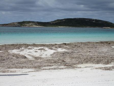
Much
better road in then ours and that’s because it is a proper campground with camp
host, toilets etc and is $15 per night. The campsites though are up the bush
and it is quite a walk down to the beach. The beach is like ours, covered in
seagrass.


Back
up the road then east again to turned down towards Kennedy Beach. The sign said
‘impassable in wet’ and we didn’t go far when we realised the sign is right.
Very rutted and then further along very boggy. We decided we didn’t need to go
through that so headed back.


Further
east then we arrived at the entrance to Cape Arid National Park and headed down
to Yokinup Bay and Thomas River. Stopped at the Info Shed for road condition
info and the site map.


A
green ‘black boy’.

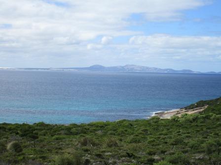
As
we travelled south we got a great view over Yokinup Bay.

Turned
off onto Dolphin Cove Road and found a lookout platform complete with picnic
table. It was past smoko but the wind was too cold to sit at the table with our
cuppa!! Stood on the table and took in the view. First – across Yokinup Bay
with Dolphin Cove beach in front. Then continuing over the bay looking across
to Cape Arid peninsula then Mount Arid before it reaches Cape Arid point.


Continued
then over Little Tagon Bay and to the west to Tagon Bay and Tagon Point.


Drove
down to the parking area for the beaches and had our cuppa out of the wind.
Followed a track to where the Tagon Coastal Trail runs. We went left for the
200m to Dolphin Cove – over big rock platform and down onto the one where
people fish from.


Below
the life ring is the safety anchor. Finished our cuppas waiting for the
dolphins to arrive – but none showed up.


Back
up to the trail sign and we headed down the other side to Little Tagon Bay.


Another
lovely view.


Zoomed
in on Mount Arid (357m elevation) and Cape Arid.


Skipped
the sandy 4WD track down to Tagon Bay and Point. Drove back to the turn
off past the NP Ranger’s house then down
to the camp grounds. View of Thomas River winding its way down to the ocean.


The
National Park camp host was out – that’s a job we might look into. I went to
the toilet and it was very clean and nearby is a lovely camp kitchen with big
BBQ and wok burner. We drove further down to the walking track down to the
beach.

Came
out onto a road which crosses the Thomas River to get onto the beach – it is a
bit high at the moment and the National Parks have closed off the alternative
route on the hillside.


Walked
back to the truck then drove back out and then down to the Shire campground
which is further back along the river. It must be handled by the National Park
as the fees and rules are the same ($10 per person per night).
Headed
back north to Fisheries Road and onto bitumen for a while then good graded road
past wide open fields with the occasional huge granite hill. Still a lot of
water lying beside the road and in the pastures. A sign greeted the entrance to
the National Park again and a much narrower track.


Around
the bend it became loose sand but not too soft that we needed to let any air
out of the tyres.

More
granite hills as we continued through the low scrub.

Then
the track became boggy but there were plenty of alternate routes around the
boggy bits.

After
that it was rough corrugations then back to the sand, bog then corrugations
again alternating for the next 46 km. Dropped down a escarpment which is called
Wylie Scarp. It was hard soil but eaten out so Steve carefully went down so not
to fall in the deep ruts.
Finally
we arrived at a very messy intersection of tracks and we found two signs which
pointed either up to Mt Ragged in the north or Point Malcolm in the south. We
headed straight ahead till we came to Lake Daringdella, a flat salt lake, just
inland from the ocean.


As
we ran along the water’s edge we met another truck and trailer.


Not
sure if the markers are to indicate the road or the edge not to go past!!


Around
the end of the lake.

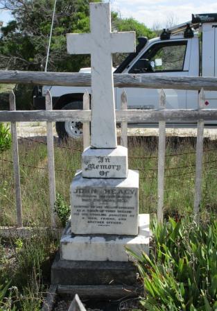
Spotted
some graves off the edge of the track so stopped for a look while Steve let
some air out of the tyres – mainly to make the ride softer over the
corrugations.


Continued
around to the ruins of the Israelite Bay Telegraph Station. An impressive
building considering the isolation. The station operated from 1877 to 1914.

I
wonder what these slots were for – looks like a mail box.


Wandered
through the rooms.


Around
the outside, then the back.


On
the other side there was a concreted pit area – ablution block?

Steve
found a couple of historical items.

Steve
thinks the green might be from batteries they would have used.

Drove
around to the camping sites, nestled in the trees. We passed two camps, mainly
men fishing and they all had four-wheelers.

Out
to the beach which is covered in seagrass too. To the east we spotted a jetty –
maybe that was where the goods came into for the station or it is a newer
addition due to the mine.


Scanning around from the east to west.


As
we drove out I spotted another ruin.

No
sign of the telegraph poles like we saw at Eyre Telegraph Station. There is a
Telegraph Track closer to the coast but it is closed at the moment. Back up the
scarp – got a photo of the ruts.

As
it was getting late we headed straight home along the bitumen then turned off
down Daniels Road to our camp. Spotted two rabbits hopping away into the bush.
We had seen two black Tiger Snakes and lots of lizards on the road.
The
sun was just setting as we got back to camp. We have visitors – a 4WD group
parked up for the night further along the beach.

Turned
out to be a nice day though it was a long drive but Steve and the truck did
well. In all we did over 300kms.
The
moon is nearly full creating a nice glow on the water.

No comments:
Post a Comment