Cloudy
again – calm sea. Packed up and headed back along the dirt road then back onto
bitumen to the west then onto the South Coast Highway, north up to Jerramungup
– Soldier Settlement Country.
The
sun has come out. Got some fuel then stopped in a park looking for water. None
available here. I uploaded a few days onto my blog. Made some lunch then went
for a walk to see if there was somewhere else we could get some water.
Mural
on the Op Shop showing how the area has developed over the years.


Checked
on road conditions at the Shire Office – still a detour around the broken
Phillips River bridge. Asked about water and the lady said we were the 3rd
person to ask but unfortunately they don’t have any taps to get water from.
Picked up some info on the area’s history. (Why does it turn the photos around!! I can't change it back)

The
Town Hall.


The
highway now heads easterly to Ravensthorpe. Across the Fitzgerald River (bit
fuzzy – this camera doesn’t do the quick shots like my old one) which flows
down into Fitzgerald Inlet, inland from Point Charles. Doesn’t look much here.

Lots
of open farming country now with lots of sheep.

Pulled
off to check out the Rabbit-Proof Fence Road which heads north from Point Ann
but no signs about it.

A
fuzzy shot of the Hamersley River which flows down to Hamersley Inlet where we
are going to camp tonight.

A
few drops of rain hit the windscreen but there was only a little cloud above
us. To the south though the rain was coming down on the mountains in Fitzgerald
River National Park – the mountains were there behind the rain!!

Pulled
off the highway into Fitzgerald Road and the site of the farms and school of
West River/Fitzgerald. Some info in the hut which is on the tennis courts. The
school and oval are behind the trees further over.


Continued
along the highway then turned off onto the gravel West River Road which then
became Hamersley Drive as we headed back into the Fitzgerald River National
Park. The eastern mountains of Annie Peak and East Mt Barren came into view.

Then
the middle mountains of Thumb Peak, Mid Mt Barren etc on the other side.

The
first part of the 40km road was good then it got more corrugated as we
continued. Stopped to check on two guys standing by their cars – they were
lost. Trying to find a mine site near Ravensthorpe and were using Google Maps
instead of a paper map. Of course the road closures had mixed them up. I told
them they will have to turn around and head back to the highway then take the
80km detour to get back to Ravensthorpe. Maybe he should have got better
information off the guy hiring him!!
The
4WD track to Quoin Head follows the Overland Telegraph line but it is closed at
the moment as it the Moir 4WD track which goes up to Ravensthorpe.
Onto
the bitumen road which was put in as part of the $40 million upgrade to the
park in mid 2014. Very nice after the bumpy road.
Turned
onto the bitumen Hamersley Inlet Road and up and down the hills to the inlet
and a flash new campground. Parked up on a nice flat pad on the hillside above
the inlet.

After
a cuppa we headed off to explore as the weather forecast I checked on before
says bad weather for the next few days!! Kev & Linda had tried to ring but
we didn’t have reception at the campsite so the message only came through when
we got to the top of the hill, even with the aerial. Rang them back – they are
heading off soon so hopefully we will catch up with them either in Esperance or
on our return trip back to Ravensthorpe before going up to Wave Rock as they
are house sitting in Hopetoun in mid March.
Decided
to go to the end of the Hamersley Drive which would normally have crossed the
Culham Inlet to get to Hopetoun but the causeway was washed away in the January
floods. Came to the road closed signs, well back from the causeway. Steve went
to go around but I said no – if a range came by it would be a hefty fine.
Drove
back to Four Mile Beach car park – looking back at East Mt Barren.

Walked
out through the picnic area to the stairs that lead down to the beach.


Zoomed
in on the inlet mouth.

Road
barriers litter the beach. You would have thought someone would have collected
them by now!!

Around
to the next beach around the point called Barrens Beach. It all looks very
nice. Good map of the area.


Some
more information on how this area was formed.


They
have created the coastline using the concrete with aluminium shapes for the
mountains.


Steve
was busy finding treasures on the beach. ‘No we don’t need one for the van’!

Lots
of weed and sticks from the floods and more traffic barriers.


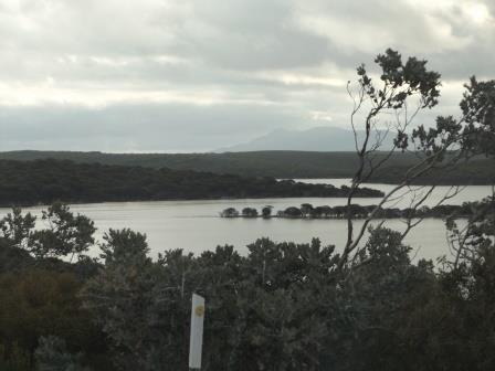
Up
the hill to Barrens Lookout. Great view over Culham Inlet, Four Mile Beach etc
then across to Hopetoun. Zoomed in on where the causeway would connect us to
the other side and to Hopetoun.


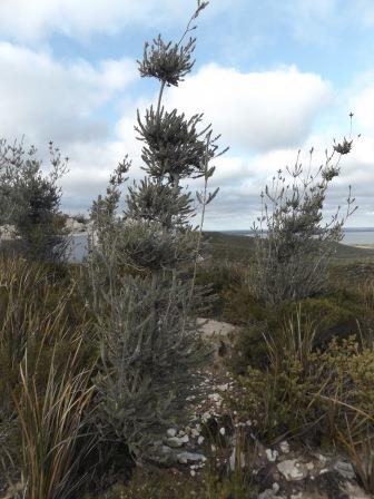
Wandered
down the path checking out all the different plants – for Dad of course.


Some
interesting shaped rocks too.


Continued
back along the road – great view over Mileys Beach and Cave Point.


Turned
down East Mileys Beach Road then wandered down the track to the sand dunes. Not
to picturesque today.


Next
was Cave Point and West Beach. Another interesting plant.


Hakea
Trail leaves from here but we will give that a miss (46km return)!! Though you
can only see those sights if you do the walk so there is a reward for those who
hike.

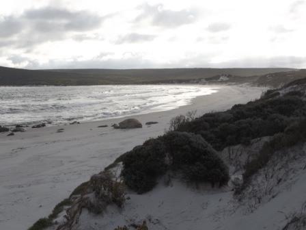
West
Beach Headland and West Beach. Zoomed in on another traffic barrier caught in
the rocks.


Look!
A Whale!! Oh no it is just a rock!! No seals or dolphins today either!!

Continued
along the nice wide concrete path, very wheel chair friendly, to Cave Point.
Looking down on the rocks.

Nice
big platform with a view of East Mt Barren, the inlet and Hopetoun and when the
time is right, Whales!!


Rugged
coastline. Found the cave but I don’t think we will be exploring it.


Further
onto the point where we found a rock cairn. Of course Steve added a few more
rocks.

Someone’s
home.

Looking
back to West Beach Headland with Edwards Point behind that.


West
Beach with Mid Mt Barren (454m), Thumb Peak (510m) and Woolbernup Hill (320m)
in the distance – or so I figure off my map.


Bright
red flowers on the way out.


Back
on the inlet road. Steep descent down gives a great view point.

Drove
down to the boat ramp area. Info on the birds, fish and the inlet.

Must
have been a jetty at some point.


Back
to the van for a late drink then dinner. Another two guys we saw before have
pulled in here too. As the causeway won’t be fixed for a while and there are
still long detours around Ravensthorpe I don’t think too many people will be
coming down the long dirt road to come and see all the wonderful lookouts etc
for a while.
No comments:
Post a Comment