No rain this morning. Packed up and headed off. Clear blue sky morning.
At the turn off a dingo stopped and checked us out.
.JPG)
.JPG)
We headed back to Palmerston to exchange the gas bottle and get the circuit breaker. Rang Erica to see how she and Terry have been. David & Amanda are taking her and Amanda’s parents out for Mother’s Day lunch on Sunday which will be lovely. Not sure where we will be to get phone reception.
Found some info about Palmerston - Originally it was the name to be given to the capital of NT in 1864 by the Sth Aust government in recognition of Lord Palmerston, Prime Minister of UK. After several site changes the capital was renamed Darwin in 1911. In 1980 the decision was made to create a new city in the Darwin area and for the third time the name Palmerston was chosen.
Stopped off at NT Prospecting to ask about detecting around Pine Creek etc. It is owned by Michael Brown and after a while Steve realised he was the chap we met years ago in Wedderburn, Vic who had found a big nugget he thought was a tin can. He had a replica of it on his desk. He knows Mark and Heidi too so we had a great chat about things. He said you have to wait till the area is burnt off as you just can’t detect through the grass as we found at the other area we tried. He said to watch out for the smoke and then go out and give that area a go. We will head that way and give it a try as we have the maps on Trilobite program so we know where we are.
Rang Greg for a chat - he has applied for another job at the hospital.
Headed south to check out Manton Dam which we missed on the way up because we went into Litchfield NP. A sign said turn off in 5kms then we saw a sign off to the right about Manton Dam and then crossed Manton River. Kept going and turned into the road to Manton Dam Recreation Area and checked out the information there. This dam was completed in 1942. Amazing to think before that everyone relied on wells. Darwin’s drinking water now comes from Darwin River Dam that we passed near Berry Springs. It is then pumped up into the big water towers we saw around the area and gravity fed to the homes. The dam covers 330 hectares and was named James Thomas Manton, one of the surveyors in 1864 who recommended the Port Darwin site as a settlement. The dam wall was built across a gorge similar to what we saw at Umbrawarra Gorge.
.JPG)
.JPG)
.JPG)
Walked across the bridge for a view over the lilies.
.JPG)
.JPG)
We went down to the boat ramp where a chap was putting his boat in. He is hoping to catch a Saratoga. Another info board with a few different bits of info. The Manton River flows into the Adelaide River.
.JPG)
.JPG)
.JPG)
.JPG)
.JPG)
.JPG)
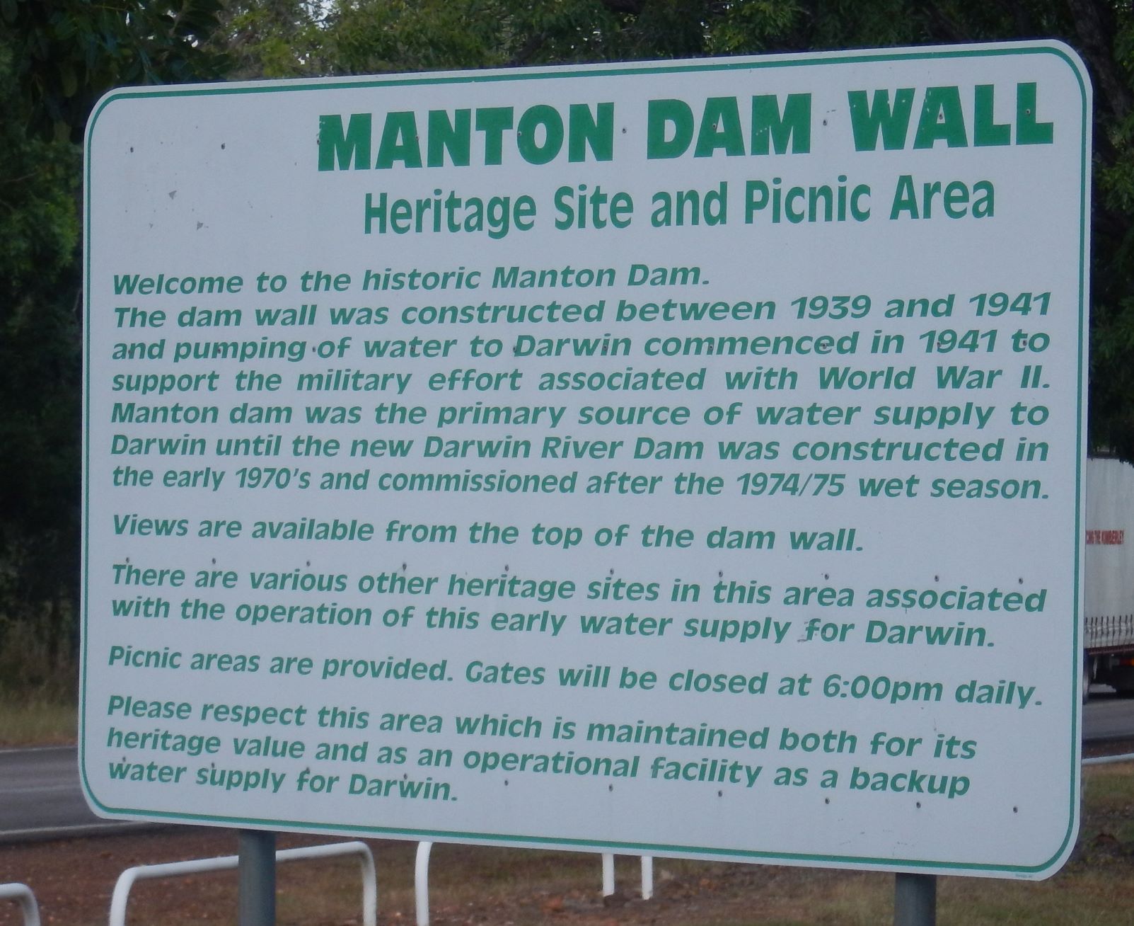
There were a few picnic tables about. We decided to go back to the other spot we passed 5km back to see what it was about. This sign is at the entrance to the picnic area beside the highway.
We continued along the narrow road around to where the pumps etc were for the dam. Read the overhead info under the hut then had a cuppa.
.JPG)
.JPG)
.JPG)
.JPG)
.JPG)
There were signs down on the grass but you can’t read them any more. Steve has wandered off. I walked over the pipes that took the water to Darwin.

The Manton Micro-Hydro Turbine is beside the pipes.
.JPG)
.JPG)
The house was for the caretakers. There is a car with no wheels in the driveway but no sure if anyone is living here now.
Beside that is the shed for the electric pumps.
.JPG)
.JPG)
Found Steve down by a croc trap. Snapped a photo of the info etc before moving on as it was very smelly.
.JPG)
.JPG)
.JPG)
Up the hill a bit was the original diesel pump house No. 1 with big values etc outside.
.JPG)
.JPG)
We continued along the track with the river one side and the pipeline on the other. One of the signs could still be read.
.JPG)
.JPG)
Next one showed where another house was located up on the hill. Only the steps are left.
.JPG)
.JPG)
The original diesel pump house No. 2 (100m from the dam wall) according to the sign. They obviously used to be open as there are numerous info boards inside but now there are signs warning of asbestos so hence they have been closed off. Unfortunately the signs outside can’t be read any more. There is water pouring out the end of the pipe into the river here. I walked down to check out the ‘river’.
.JPG)
.JPG)
.JPG)
.JPG)
.JPG)
.JPG)
.JPG)
Onto a boardwalk now. One sign can be read - the next one can’t.
.JPG)
.JPG)
Continued on till we reached the dam wall. No water flowing here hence they are letting it out further back at the pumphouse.
.JPG)
.JPG)
.JPG)
.JPG)
We walked back to the pumphouse then around to the high side where the old oil storage tank stands.
.JPG)
.JPG)
We followed the path upwards to the top of the dam wall.
.JPG)
.JPG)
.JPG)
.JPG)
Headed back. Spotted a couple more signs up on the hillside. One about the soldiers who were camped around here and the other about the other oil tank that was on this slab. Now only the bower bird uses it but obviously not at the moment.
.JPG)
.JPG)
.JPG)
As we headed back to the truck we heard crackling. Steve thought it was the leaves in the strong gusts but then we noticed smoke and then we smelt it. There is a fire across the creek from us.

We drove back out to the picnic area beside the road to make a cuppa. We can hear the crackles louder here so maybe they are burning off the grass by the road. This is the burn off time now and we have noticed a lot of smoke around.
Back onto the highway and yes it is an official burn off as the trucks with flashing lights were going along ahead of us heading back to the Manton Dam Rec Area turn off.
.JPG)
.JPG)
.JPG)
We continued on then I saw a sign about Lake Bennett (8km away) so we turned off and followed the windy, hilly road through bushland then past a lot of horses and down to the Tourist Park. We kept following the road and noticed no entry signs etc (private land - residential estate and waterway) and realised it was for the road not the land as this road lead around to cabins with pontoons on the edge of the lake that are owned or rented. They are all beside each other at this end and along the roadside. We turned around and headed back out.
.JPG)
.JPG)
The sky looks stormy but it is the smoke from other fires around the district.
Through Adelaide River township and across the river then down Dorat Road back to camp beside George Creek and Robins Falls where we had been for my birthday. A few campers are here but our spot was free so we back in beside the pool and set up camp. Sound of running water again as the water is still spilling over the little dam right near our back door.
Someone has made a drinks table with 5 slab rocks for seats around it - very cute.
.JPG)
.JPG)
.JPG)
.JPG)
Met John and Kay from near Melbourne and joined them for drinks.
Easy dinner tonight then a few games of Canasta again - Steve is getting better. All quiet expect for the babbling brook.
No comments:
Post a Comment