7.45am
12 degrees, overcast and very cold wind. Sun trying to peek through.
Packed
up in the cold wind!!
Headed
off past the ‘closed’ Inside Track. See map.
The Inside Track – not maintained
and is impassable when wet.
This track was the route used by drovers. It follows
permanent waterholes of the Diamantina River as far as Goyders Lagoon. Cattle
were then dry-staged for long distances between semi-permanent and casual
waters until they reached Hergott Springs (Marree). Water evaporated rapidly
and many mobs of cattle were trapped on the track without water. Thousands
died. The first bore was drilled at Marree in 1884 and by 1907 water was
flowing from most of the bores on the track, making the movement of stock much
easier and safer.

We
are going up the Outside Track. Still flat and rocky.
The Outside Track
This track was developed due to the inability of motor
vehicles to negotiate mud and creek beds when crossing Goyders Lagoon in the
wet. Cattle were still taken down the inside track until the 1960s but they are
now moved by road transport along the outside track.

The sky is clearing ahead of
us. Came to a sandridge which we have run alongside of and now we are going
around the end of it and continuing on more flat ground. Across a sandridge
then more flat country. I would miss not having mountains around me if I lived
out here. Passed the turnoff south to Walkers Crossing which goes down to
Moomba.
Next is the track beside
Koonchera Dune. But as you need permission to go in we gave it a miss.
Koonchera Dune
This is one of the largest dunes on the Diamantina
floodplain and is protected by heritage legislation. Samples of flora and fauna
were taken in this area before cattle were introduced and rabbits drove out
many of the small mammals. It is believed that a large number of Aborigines
were massacred near Koonchera Waterhole. This was retribution by Europeans for
the killing by Aborigines of a European who had taken an Aboriginal woman from
the tribe. The dune is protected for these reasons.
Stopped
to check out this old car sitting in the middle of nowhere.


Turned
around to get a photo under the Birdsville Track sign. Interesting choice of
picture as we haven’t done any dune climbing on the track.

Went
around the back of the white sand ridge nearby trying to get out of the wind
and dust to have a cuppa. Still windy but no dust here as it is all gibber
stones.

Looking
across the flat to the next sand ridge.


Further
along we passed Geake Hill where a bit further east the Page Family passed away
in 1963. Such a sad story – I had read the news article about them in the
Marree Hotel.
Page Family Grave – Ernest
Page and four members of his family left Marree on Christmas Day in 1963
heading for Queensland in search of work. After following a well-defined
station track that took them away from the main road, their vehicle broke down
and the family tried to walk back toward the Birdsville Track, presumably
trying to reach Clifton Hills Station. A steel cross marks their grave near the
coolabah tree under which they were found. The grave is on private property, some
distance from the Birdsville Track.
More
sand ridges appearing – average height 21 metres according to our Hema map.
Onto Pandie Pandie Station. The track is running parallel with two sand ridges.
Felt like we were back on the Canning Stock Route again though this track is a
lot wider and well formed. Sandy flats now rather than the gibber stones.
The
clearing sky has disappeared and dark clouds are coming over.

Then
it rained!! You should have heard the sound of the mud being flicked up off the
tyres. I took a video to record the racket.


Got
through that and back onto the dusty track again.

Past
some old and new yards then the airstrip and sheds for Pandie Pandie Station
then the homestead which is near the banks of the Diamantina River. Average
sand ridge height around here is 10 metres. It is looking more like a ‘desert’
here.


Lots
of signs greet us as we head to the SA/Qld Border. I like the population number
for the shire. The Diamantina Shire covers 95,000 square kilometres, yet is home
to just 11 cattle stations.

Got
a photo with the SA sign too.

Across
the grid into ‘sunny’ Queensland!!


The
border fence is called The Poeppel Line. It was named that to recognise the
work of Surveyor Augustus Poeppel who led the survey party working on the
Qld/SA border from1878 to 1881.

Back
in Queensland. More signs.


Driving
tips – Mobile Phones do work in Birdsville!

Continued
north then turned off the main road and headed into Birdsville past the Race
Track. The information plaque is very hard to read but I got one bit of info.


Stopped
for a photo under the big info board. Great aerial photo on another sign.


Turned
onto a track down through lush green grass as we head down to the Diamantina
River.


Checked
out the old crossing where the murky water is running under the causeway.
Upstream then downstream. Maybe they got some of the storm.


Back
out - the green grass is only in one area.

Across
the bridge over the river – up then down.


More
green grass as we head into town. There is a bore drain that flows down into a
wetlands area before flowing into the Diamantina River downstream of the old
crossing.

We
will explore Birdsville when we return in October so we just did a drive around
past the ruins of the Royal Hotel. Will have to have a drink at the pub next
time. The airstrip is ‘in town’.


Stopped
at the iconic Birdsville Bakery. We forget about the time change so we were
late for ‘lunch’. Luckily there were a couple of pies left, lamb for Steve and
spicy chicken for me. Must say it was very tasty but the pastry wasn’t cooked.
We had camel pie at Lara’s so we didn’t need to have one here which is what
they are famous for. There are lots of great photos hanging on the walls.


Interesting
toilet roll holder!

Sturt
Desert Peas in the front garden.


Checked
out the Information Centre. More rain predicted so we will continue on. Lots to
look at. Found the Burke & Wills Slash Tree replica, one of the busts of
Tom Kruse (the mailman), Poeppel’s plaque and info about Gibber Stones and Moon
Rocks.
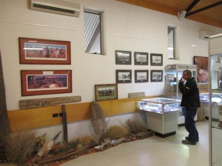


Great
aerial photo of Birdsville and a scary one of a sand storm.


Another
wall had more information boards.


Picked
up brochures etc and then headed down the road to the Artesian Bore. A chap was
working there so the cooling pond was empty.


We
drove back out to where people can camp and topped up the water tanks. A cute
little bird was having a lovely bath.


A
few texts had come through so we returned some calls. Rang Malcolm to give him
road conditions in case they want to come up through Marree. Rang Erica to say
we are heading their way. They are still at Sapphire so we will join them there
instead of Woodgate. Rang Mum and Dad, doing well. Dad said when they were in
Birdsville the race track was covered in a foot of grass after all the flood
water. Sent the boys texts so they know we are alive!! Pete had texted so gave
him a ring too. We have done 7515km so far since we left the van on 1st
May.
Past
the old Windmill then down to the Burke & Wills Slash Tree for a cuppa. The
sign is facing away from the tree so people drove up and we had to point it out
to them. Lucky I took a photo of the replica as there isn’t anything left here.


Rang
Bob & Margaret then Kev and Linda for a chat.
Turned
onto the Birdsville Developmental Road – bitumen for just a bit. A few more
drops of rain then it got heavier. There is a lot more places and things to see
out here but we will do that one day when we explore this region in more
detail. We have done the Matilda Highway with the boys years ago.


Over
a few red sand hills then crested one for a lovely green view - water from a
dam on the right. Back into red gibber stone country with a few hills as we
enter Roseberth Station.


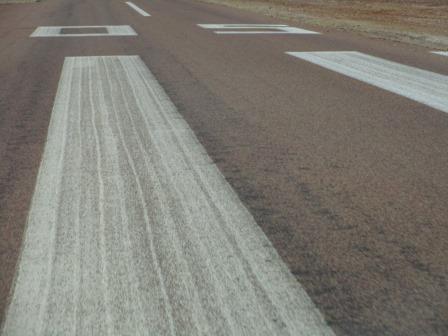
A
few bitumen sections over floodplains and crests. Over a RFDS landing strip on
the road.
Storm
clouds are still around us dropping rain here and there.

Onto
Durrie Station, over flats then red sand ridges with more gibber stones. Good
road.
Lots
of trees in Cuppa Creek but the creek was dry.

We
found a spot up the creek to camp. There are lots of dead trees for the fire.


The
sun is shining in the west under a big cloud. The wind has settled and no more
drops of rain – so far!

Our
route for today.

The
wind picked up then we heard thunder rumble and a few flashes of lightning.
That storm went west – great watching the lightning strikes. The wind then
changed and it blew straight into the bed side of the truck. We shifted things
around just as the rain came down. Closed the kitchen door and climbed into bed
then pulled that door down too listening to the tarps flap in the wind, hoping
the awnings hang in there.
No comments:
Post a Comment