7.15am
5.7 degrees. Just missed the sunrise over the flats because we close the door
to keep the chill out. Nippy breeze makes if feel like 3 degrees.
Got
some hot water for our ‘washing machine’ then packed up.
The
Dip sign artists are at it again – SerenDIPity.
The
road ahead and looking across the top of Lake Harry. Just red dirt – not a
plant on the lake itself.


Across the vermin proof fence again as it heads east from Muloorina. The alarm went off again as we crossed the grid. There was a faded notice at the Marree Hotel about the new improvements to the fence and the costs but it was hard to read.


Into
Clayton Station – home to the Oldfield family since 1954. This cattle station
covers 1,000 square miles. A group of horses were grazing by the track. Clayton
Station is renowned for breeding Clayton Waler cross working horses, known for
their endurance and temperament which made them the horse of choice for the
2002 and 2005 Great Australian Outback Cattle Drive. The Waler horses were used
in the first World War in the Light Horse Brigade.


Plenty
of trees in the Clayton River but no water. It also ‘flows’ into Lake Eyre.

The
Station campground is just off the road by the river ($10/vehicle/night) and
this is a spa pool filled with warm artesian water when required. Mr Unimog man
again. A chap said the water is about 50 degrees. As the cold wind is blowing
and it is out in the open we think we will skip it.


The
station homestead is on the other side on a ridge. They have cabins there and
there is a wetland around nearby because of the artesian bore.
So
flat then over a red sand ridge onto flood plains, according to the road sign,
for the next 10kms.
The
sand ridge continued parallel with the track then we turned away from it but I
can see that it continues on for miles. All flat now except for a couple of
small hills on the right.
Into
Dulkaninna Station.
Black
rocks started to appear by the road and were piled up into a cairn.


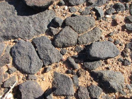
Stone Cairn
Cairns or piles of rocks are often built for
trigonometric surveys. The surveyor (in this instance probably Samuel Parry in
1858) employed men to build and dismantle cairns as required. A large block of
stone at ground level is marked with exact co-ordinates and the surveyor’s
theodolite placed over it. After theodolite sightings are completed a cairn is
built over the marked block so this point can be seen from a distance by the
surveyor.
The
wind is still very cold. Further along we spotted some greenery in this vast
area of red dirt. Spotted some water and guessed it was an artesian spring.
As
we got closer I noticed a black thing and we both said ‘is that an ostrich’.
And it was. Maybe someone was breeding them and this one got away.


Nice
big pool complete with ducks.


The
wind was ruffling the ostrich’s feathers. Then we noticed he was heading over
to an emu on the other side of the fence.


Nearing
Dulkaninna Station homestead where they have the ‘Coolibah Campground’ by the
Dulkaninna Creek. The track turns off for the campground and winds its way past
piles of water pipes then around to the creek which of course is dry. Big area
with covered area, big fire pits and toilet block surrounded by lovely
Coolibahs ($25/vehicle/night).


Back
out to the Birdsville Track and over the creek which did have water in it. It
is coming from the artesian bore wetland. Lovely pool on the right and dry and
barren on the left.


Continued
on – I could still see that red sand ridge in the distance. The land here is so
flat that it looks like water. Into Etadunna Station.
I
was looking out for Milner Pile but we missed the rock cairn. Took a photo of
the one from my map.

Milner Pile
This was named after Ralph Milner who set out to win a
reward offered by the SA Government for the first drover to overland stock
across Australia. Milner and his party left Adelaide in 1863 with sheep, cattle
and horses. Drought stranded them near Lake Bucaltaninna on Cooper Creek for 7
years. Milner moved to Kopperamanna then later moved again to Killalpannina.
Milner’s wife Sophie died soon after they arrived at Killalpannina and was one
of the first to be buried there. In 1870 Milner again set out with stock,
following the survey team tracks along the OTL. Milner provided meat for
workers on the line as he moved toward the northern coast.
Despite the death of his wife, the killing of his
brother by Aborigines, loss of 1,500 sheep from poisoning, and the sale of
1,200 sheep to the OTL construction party at Toper River, Milner managed to
maintain his mob by lambing and arrived at Darwin with 2,000 head. A change in
government meant Milner did not receive a reward for his effort.
Wide
flood plain of Cannuwaukaninna Creek – get your tongue around that!! It
connects to Lake Gregory which is east of here. Rocky road base making it
nearly as bad as corrugation.
Past
the station homestead and then the turn off to Killalpaninna Mission.
Etadunna, Killalpaninna and Kopperamanna
In 1866 a group of Moravian missionaries set up a
mission station at Kopperamanna. Some months later another mission was set up
by Lutherans at Killalpaninna. Extreme hardship forced the missions to close
but in 1873 the Bethesda Mission was revived at Killalpannina under the
leadership of Pastor Vogelsang. After years of dedication to the Aborigines the
mission finally closed in 1919. Lance Powell took up the lease but severe
droughts caused him to relinquish it in 1929 when it was amalgamated with
Etadunna Station.
Pastor
Vogelsang’s grave is one of the few remaining reminders of this mission that
had 21 buildings and a handsome mud brick Church. Although Vogelsang tried to
give the mission a commercial backing to help it survive by running sheep and
cattle, drought and wild dogs continually took their toll. The Dieri Aboriginal
people dispersed. Some went to Marree, some to Hermannsburg and others went to
the mission at Finniss Springs established by Francis Dunbar Warren to provide
a refuge for his family and other displaced Aboriginal people.
Further
along we found the punt used to ferry people and goods across the Cooper Creek
when in flood. Dalgety & Co Ltd provided this punt to ferry supplies and
mail across the Cooper Creek when it flooded in 1949. Now when the waters from the Queensland’s Channel country reach
the Cooper Creek and cut the Birdsville Track, a detour leads to a ferry that
operates during daylight hours.


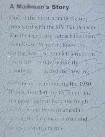
The Cooper Ferry
The track around Lake Killamperpunna (part of Cooper
Creek) can only be used when the main track is flooded. Then a ferry is
operated by the SA Government. The steel punt used in 1950s by Tom Kruse, the
Birdsville mailman, is now on display beside the road south of Cooper Creek.
Looking
down to Cooper Creek.

Sadly
the information board is hard to read but I got the bit about Tom Kruse, the
mailman.


No
water in Cooper Creek at the moment. We checked out the Cooper Creek
‘campground’ which so nowhere near the creek – just open spot with lots of
bulldust so we continued on.


The
map showing the Cooper Creek path.

Through
the Natterannie Sandhills where Steve spotted a nice plank of wood on the road
- we might just need that.


The Natterannie Sandhills
These were the most difficult section of the
Birdsville Track, especially after the introduction of Harry Ding’s mail truck
in 1936. Tom Kruse drove this truck for many years and had a permanent supply
of iron sheets amongst the dunes. These were placed under the wheels so that
the truck could cross, but it took hours, sometimes days to get through.
We
just drove up and over the sandhills. The Tirari and Strzelecki Deserts meet in
this 10km stretch of long and narrow sand dunes.

Onto
Mulka Station. Spotted some ruins so went over a sandhill then around a creek
to check it out. A couple of wells were nearby.


Left
the rolling sandhills as we went back into flat open country between two long
sandhills. Turned onto a track across to the ruins of the old Mulka Store .
Another unreadable sign and a scoop they used to dig out dams.


Mulka Store
The Scobie family is one of the best known names on
the Birdsville Track and although Scobies are now scattered far and wide, their
roots are firmly founded in the ruins of Mulka Store. Mary and Alexander Scobie
were married in Victoria and lived there for several years before moving ‘up
the track’ in 1883. It took Alexander two years of adversity, pain and hardship
digging wells, looking for suitable water. He called this place New Well and
eventually built a home here.
The Scobies had come to New Well with four children.
Another three were born later. Unfortunately, as was the case in many parts of
the outback where often only the strongest survive, the two youngest, Adeline
and George, died of pneumonia and are buried behind the house where an iron railing
protects the graves.


The windows make good frames for the photos.

Heated
up some soup and a tin meat meal for lunch as we needed warming up. The wind is
still strong and cold but if you can hide from that it is very nice in the sun.
Continued
on through sandhills then onto the Sturt Stony Desert with wider plains and a
couple of sandridges in the distance. Of course there are lots of stones but no
different to anywhere else along the tracks.

We
enter the Lake Eyre Basin – Georgina & Diamatina Catchment area. Amazing
when you look at the map of these deserts and it is covered with lakes!!

We
must have taken a wrong turn as we are crossing the Derwent River – looks a lot
different to the one in Tassie.


Into
Mungerannie Hotel & Campground. $10/person/night & diesel is $1.90 per
litre. The hotel is on a lease separate to the Mungerannie Station.
This was originally taken up by William Crombie about 1888. A police station was opened in 1903 and closed in 1928. A roadhouse now serves travellers along the track.
Lots of interesting signs and trucks. This area is where the three deserts meet – the Tirari, the Strzelecki and the southern reaches of the Simpson Desert.


The
sun was coming through so had to take lots of photos of the information boards.


Another
Kidman info board.


Inside
the hotel the ceiling was covered in all kinds of apparel as well as beards
& ponytails.


Lots of photos of the Cooper in flood and the new ferry and one of Tom Kruse on his mail round.


Continued
on and crested the hill and we greeted with a lovely view of hills.

Further
on we were back on the flat ground again as we headed into Cowarie Station.

Stopped
beside Mirra Mitta Bore which has just been capped. It was sunk in 1901 and is
1,076 metres deep. Now there is just sludge where the hot hot water used to
flow. We can see it spraying further over behind a fence.


Mirra Mitta Bore
This is one of the Birdsville Track’s hot flowing
bores and the only reminder of a wayside store and vegetable garden owned by
Josia Dunn in the 1930s. The windmills reticulate water from cooling ponds to
other parts of the property.
Photo of what it used to be
from one of the brochures.

I
decided to follow where the water used to flow down and found water flowing
further down. The water is so clear.


Then
I saw some steam coming from the grass and I could feel the heat from where I
was standing.


We
drove further along and spotted a caravan by a dam so drove in to check it out.
It is one of the cooling ponds. The water is cold.

Some
men were resting in the shade of the big trees that obviously is home to lots
of corellas going by the poop and feathers everywhere. Steve chatted with them
while I made a cuppa. They were French though one chap has been living in
Brisbane for 10 years and he was taking some friends, who didn’t speak English
well, on this adventure. They hired the BMW road bikes and they had the 4WD to
carry all the bits and pieces. They enquired as to the condition of the track
as they were heading towards Marree.


We
walked along the edge of the cooling pond to chat with the couple in the van.
They were from Victoria and were travelling with their cat, Mushy, who was so
cute. They gave us information about camping in Birdsville. They said there has
been a lot of changes in Birdsville and the Track since they were last there in
2011.


Looking
back over the pond and then up the little channel that brings the water down
from the bore.


Continued
on – water over the road is coming down from the dam overflow, creating a
wetland.


Another
big ‘lake’ area to the west of us which is called Lake Howitt but nothing there
to see other than a flat empty plain with a ridge in the distance.


Low
hills appearing and flat topped bigger ones though Mt Gason is only a small
hill.
Mount Gason
This mount is named after mounted policeman, Samuel
Gason, who published a vocabulary of the Dieyere Aborigines written during his
many years in the outback. One of the boiling bores nearby is similarly named.
Mt Gason Wattle (Acacia picardii) is a rare plant that
appears to produce very little seed and is thought to reproduce from suckering.
It is only known to grow in one other location which is in NT, a few kilometres
from the equally rare Waddi trees on Andado Station.
Into
Clifton Hills Station. Skipped going into the bore to see the ‘rare’ acacias.
Travelling
parallel with sandridges again. A bore water hole for cattle who are meandering
over the road. This section of the track has been very bull dusty. Ground still
covered with red gibber stones.


Past
the turn off to Warburton Creek and the K1 Line which leads up into the Simpson
Desert. Obviously the signs are checked on regularly.


Not
much growing on these rocks but there are green trees in the creek as we near
Clifton Hills Station homestead which is well off the track.


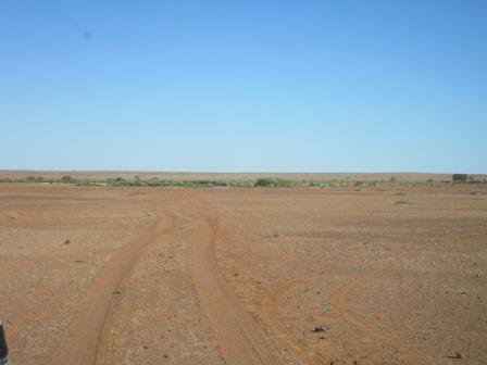
Stopped
at Tippipilla Creek for the night. The wind is still blowing strongly so set up
accordingly as the sun was setting at 5.30pm. Looks lovely with the clouds.


Our
route for the day.

We
hung out the washing between two trees and got a fire going to get some coals
for our lovelies warmers as we will need them tonight. Only 17 degrees on the thermometer
but it feels a lot colder in the wind.
No comments:
Post a Comment