7.40am
13.8 inside the truck and 13 degrees outside. A bit clearer sky to the east but
still black clouds to the south west. A few more drops of rain in the early
morning. The tarps and awnings held together in the strong wind.
Fran’s
birthday – hope she got her card I posted.
Lovely
double rainbow when I got up.


Bit
of water in the bowls from the rain.

Packed
up with the wind still howling but at least it isn’t raining. Water on the road
and in gullies as we head off. The gibber stones are glistening in the sunshine
that is peeking out between the clouds. Still black sky to the south and west.


Past
the turnoff into Durrie Station homestead and into light red long sand ridges.
Nice views as we crest some ridges.


Good
signs on the crests.

Need
one for the wandering cattle! Took a video of them.


Up
the Durrie ‘jump up’, onto a ridge where the land falls away each side with
green tree lined gullies and creeks. Very pretty though still red gibber and
yellow grass.
Farley
‘jump up’ next then to the plains between the rolling hills.
On
the side of a hill is a pointed rainbow serpent which was created in 2012 –
very impressive.

We
made a cuppa then wandered over for a closer look.


Went
around the hill to find the end.

The
road normally went up to Betoota where there was a hotel but it is closed so
there is a new track that goes straight instead. Will drive up and check it out
on the way back.
Across
Brown’s Creek – water in a long lagoon on one side. Scalloped hills appear as
we reach Betoota ‘jump up’ and Deon’s Lookout.


Great
spot but not when there is a strong cold wind blowing. Quickly took some photos
of the info board.


Sad
story about Deon.


Fabulous
view. Hope it isn’t windy when we come back.


Across
a grid into Barcoo Shire – Heart of the Channel Country. More people heading to
Birdsville. The Big Bash concert is on soon and we saw people setting up for a
Big Red Run in Birdsville.

We have our music playing that I got off Sandy and
we are listening to Horse with No Name – riding through the desert – I sung we
are riding through the desert in a truck with no name. Steve said we should
call it Pat for Patrol as we have ‘Fred’ our 4WD Hema man who greets us each
morning with ‘GPS fix ok’. The street one is ‘girlie’ as she is always getting
up Steve about something!!
Flat
open country with a range in the distance on the right. Over another RFDS
strip.

Past
the turn off south to Haddon Corner and Innaminka which we will do on the way
back. Spotted a few Queensland kangaroos.
Right
turn onto the Diamantina Developmental Road which is bitumen so pulled into the
rest area for lunch. There is a picnic table, shelter and toilet so we parked
behind the toilet to get out of the wind. Steve put some air back into the
tyres now we will be on bitumen for a while. Unfortunately there are also
hundreds of flies that can fly faster than the wind!! I made my lunch then sat
in the truck to eat it.

Saw
a sign saying the Betoota Hotel is reopening so will definitely go and check it
out on the way back.

Checked
out the information boards in the shelter. Welcoming sign about snakes!!


Continued
on the narrow bitumen road which was rougher than the dirt. Turned off to check
out the gas pumping station. Steve thinks compressed air is added to help move
the gas along the pipes. Drove around the compound.


Mt
Henderson (241m) has a hole in the rock at the top. Lined up with the pointer.
Looks like a few caves up there.


Nearby
was a very red rock hill.

Stopped
to check out a ‘Native Well’. We feel like we are back in Meeka country –
looking at the map we are level with Meekatharra.


Next
stop was a J C Hotel ruins. A few stumps
and some bottles are all that remain.


Through
red dirt flood plains which are covered in desert oaks. A bright red sand ridge
appeared as we head into open flat country again.

Poor
windmills have lost their blades but the pastoralists have found good use for
them as signs. All the bores are worked by solar pumps now. Three emus darted
across the road. Managed to get a photo of one.

Narrow
road and flat plains. Then a sand dune here and there. A flock of galahs flew
over us.


Into
Windorah, population 80, where we topped up with fuel ($1.71per litre). Neat
town. Surveyed and gazetted as a town in 1880 with the first police station and
post office built in 1881. The telegraph line went in in 1885 and the school
was built later in 1888. Their water supply comes from Cooper Creek, 10km away.


Someone
didn’t have a nice flight.

Cute
little cottage.

Picked
up a brochure from the info centre which has a slab hut (c1906) which was
originally built on the banks of the Whitula Creek. Obviously the boat is for
crossing Cooper Creek.


Some
info about John Costello who built the JC Hotel that we went to earlier and
some info about the Barcoo Shire.


We
headed out to Cooper Creek stopping to check out the big solar power plant. I
wonder how much it is generating today with the overcast sky.


Turned
onto the track before Cooper Creek. Sturt’s reason for calling it a creek
rather than a river. Looks like a nice spot to camp though the campers are all
wearing fly nets!


Across
the bridge looking upstream then downstream. There is 10km of waterholes so a
little house boat would be good.


Made
a cuppa then went for a wander around. Remains of one of the old ferry punts.


Steve
found a memorial blaze for a stockman who drowned in the Cooper in 1974.

Walked
down to the water. Another van went across the sand to park up. You can see the
flood level marks on the trees.


Steve
chatted with a couple who were recently land locked at Muttaburra due to heavy
rain there. The diesel tanker got bogged in a dirt detour of road works so the
town ran out of diesel. There was lots of beer though.
Back
towards Windorah then we turned onto the Thomson Developmental Road to Jundah.
I wonder why they need the ‘developmental’ bit now. A much better road. A few
drops of rain from the big black clouds still hanging over us.
As
we crossed Tommy Dodd Creek a few roos were by the road. One darted across in
front of us at the last minute but good driver Steve missed him. Another one
sat there till we came up beside him then he darted onto the road – talk about
dumb animals. If I thought something was big and threatening would you think to
go in the opposite direction?
Still
flat country with a few hills, creeks and flood plains. Silly roos are sitting
in the middle of the road – no grass there!
A
wedge-tailed eagle is sitting in the tree deciding which of the two recent
kills to have first.
Lots
of water in pools and little creeks from the recent rain.
Across
the Johnston Channel, part of the wide waterways of Thomson River. Nice camp
area by the river.


Into
Jundah – cute welcome sign with lots of information.


Black
clouds to the east but looking brighter to the north.

Past
another ‘native well’. Rain drops again. Rest area with a look out at the top
of a ridge but we didn’t stop. Steep descent onto the plain of Swanvale and a
long straight bit of road. Lots of green trees as we crossed Deep Creek which
was dry. Such a change to see so many trees.


Up
and down rises then stopped to check out the ‘Minions’.

I
had read about the Stonehenge Address Book. Years ago the mailman left his name
in rocks on the side of the road and since then people have stopped and added
more. Like the ones we saw on the Canning. We were amazed at how many there
were. Went for quite a while.


We
found a spot near a culvert that was clear and set about making our own sign –
2 Geckos. GPS mark 24 21 21.3S 143 20 22.7E. Will have to add the ‘travelling’
part when we return.


We
didn’t go into Stonehenge as it is off the main road. Will check it out another
time as there is lots of interesting things to see around here. Obviously they
didn’t feel they needed to put up a copy of the English Stonehenge to bring in
tourists.
Through
black soil country around Emu Creek which had a bit of water in it. Then onto
flat plains again. Another black cloud dropping a few drops of rain on us. Can
see lots of rain scuds to the east. The sun rays are pretty.

Had
to stop to allow a flock of sheep to cross the road – got a video of them.

More
sun rays photos.


The
next lot of sheep were behind the fence with lots of lambs.
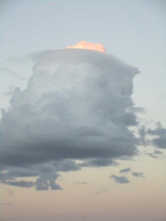
Steve
thought this cloud looked interesting with the sun highlighting a bit at the
top.
Rain
came down as we arrived at the Rest Area we were going to stop at. It was just
a toilet up on a rise in the middle of nothing. Wikicamps said there was a
gravel pit campsite 80km up the road (35km south of Longreach) so we kept
going. The sun had set behind the cloud. Luckily no more roos, just a few cows
to keep an eye out for.
Turned
into a big open pit which had a few cows wandering around it. We found a spot
to park up for the night. Our route for today.

I got dinner underway while Steve got the fire going.
It is warmer tonight which is nice, 21 degrees, but there is a nippy little
breeze. The sky is clear here and a lovely full moon is shining down on us.
Rang Tom and Sandy to let them know how we are going. Tried Jeff but no answer
to left a message.
10pm
16.6 degrees. A few clouds coming over and we can see lightning in the
distance.
No comments:
Post a Comment