7am
29 degrees, clear sky and the wind is back. It had stopped about 1am then came
back as the sun rose.
Packed
up and headed back to the main road then 40km up to Carnarvon. Nice gums trees
line the road which is lovely to see after all the flat country recently. It is
the only point of Australian coastline where the central desert reaches out to
the sea.

Big
Banana. Carnarvon was the first location in Australia where bananas were grown
and the first bunch was produced in 1928 by Jack Buzolic. It supplies 70% of
WA’s winter vegetable requirements, producing over 30,000 tonnes of fruit and
vegetables every year from its 176 plantations. Bananas aren’t actually a tree
– they are the world’s biggest perennial herb!

No
free camps in town so we booked into a van park for $30 a night with power and
it is the best rated van park in town. Off season is good as it is cheaper and
there is only 3 other vans here so the lady just said to choose where we
wanted.
Parked
under a big tree for some shade as it is quite hot and the wind is less in
town. No flies either.

Had
a cuppa outside in the shade as it was 39 degrees in the van. Rang Erica &
Terry then Mum and Dad. Sent the boys/girls a text each updating them on where
we are. Both places had a maximum of 34 degrees today.
Went
for a drive into town. Drove
around the fishing boat harbour which is on one side of the Fascine Inlet (see
map). Looking across to Pelican Point then down the inlet.


Nice
foreshore area.

Lots
of leaning trees opposite the airport – testament to which way the wind blows here.


Over
the Levee Bank to check out Chinaman’s Pool in the Gascoyne River – not looking
too nice at the moment. It was the main source of fresh water for the town in
the early days.


Back
to the van for lunch.
Drove
back through town then out to One Mile Jetty and Museums. Nice map of the town and
it’s features.

Unfortunately
due to it being summer season now the museums were both closed today. We checked out
what was outside as we have been through a few museums in our travels!
First
the lighthouse (built 1896) and keeper’s cottage (built 1897). The original
lighthouse top in front of the current one which still operates.


Also
on display is the remains of ‘Little
Dirk’.


Walked
across to the One Mile Jetty – now in disrepair so we can’t walk out on it any
more. I peered through the viewing hole and zoomed in down to the end of the
jetty.


A
couple of history information boards. The jetty was built in 1897, in 1904 the
head of the jetty was added and in 1912 the jetty head was widened because of
increasing traffic, including passengers. Carnarvon was the first port in WA
which loaded livestock on board ships for transport to markets. The jetty once
boasted an animal race the length of the jetty along which sheep and cattle
were driven from holding yards were the Museum is today. The tramway ceased use
in 1966 when state ships stopped calling. Road train transport commenced then
the jetty began to fall into disrepair until 1998 when the community banded
together to save what is the longest jetty in the north of the state. There
used to be a Coffee Pot Train for the tourists then. Unfortunately time and
erosion has taken its toll and it is now closed.


Lots
about the different marine life of the area – I just took the one about the
Dugongs. This old history one shows an Angel Fish - doesn’t look anything like
the nice ones you find in aquariums.


Walked
around to the verandah of the café which is part of the Interpretive Centre, closed
today for a better view of the jetty. There are some people down the very end
fishing. They just climb up from the beach.


Inside the centre is one of the
lifeboats in which 46 German survivors of HSK Kormoran came to shore north of
Carnarvon at Quobba and Red Bluff. 318 of the 380 crew survived. The first of
the survivors (25 of them) were picked up by a British tanker SS Trocas on 24th
November. More rescues followed, including one lifeboat contained 62 men and
Captain Detmers. Many crewmen were held in the Carnarvon Gaol for just two days
before walking the One Mile Jetty to join the others aboard the MV Centaur for
the journey to Fremantle and, after interrogation, were dispatched to
prisoner-of-war camps in WA and Victoria.
The
jetty was for a tramway which came from in town. This area was actually an
island, Babbage Island and is connected by a causeway (called Shark Skin
Crossing) which was also flanked by the Gascoyne River on the north side and
the north end of Inlet on the south side.

There
are old wagons and railway history here as well as another museum tells the
story of the jetty, tramline and shearing days. The first wagons were pulled by
horses but in 1909 they were replaced with steam locomotives then with diesel
ones.


We
followed the river trail and read the info boards along the way.


This
sculpture ‘Don’t Look at the Islands’ is about the aborigines who put on two
islands out from here between 1908 and 1919. There was more information on
boards near the entrance. Now it is home to some endangered animal species.


Continued
along the trail. Nothing left of the meatworks other than a bunch of wrecked
cars which look like they are from that era of time.


There
was a road here too and lots of out-of-work people squattered here in the 1930s
but they wouldn’t have cars I suppose.


The Gascoyne River – this water is only from the sea coming in. It is dry further on but is wet under the sand. Very interesting. The fruit and vegetable plantations around here use lots of bores to bring up the water to irrigate with, since the 1920s. We figure the timber structures were groins to help stop erosion when it does flood. Looking back along the river to the ocean and a narrow entrance which is different to what is shown on the maps.


More
info about the whaling station that is now used for prawns.

Back
to the truck and down the road to Pelican Point, passed the turn off down to
the old whaling station. View around the inlet called The Fascine, the named
derived from Bundle of Sticks – early attempts to stop erosion of the
foreshore. Mangroves, bit different to Cairns ones, Carnarvon township then
along the foreshore to the small boat harbour area (on other side) where all
the fishing boats and fish sales areas are, out to the ocean past the sandy
point where they are dredging.


Back
up road, which the sand dunes are trying to take back, to the Jetty and back
into town.

Parked
near the old tramway bridge which linked Carnarvon to the One Mile Jetty.
Across the water is a newer subdivision, complete with water frontage.


Walked
along the bridge to the other side which is Whitlock Island – which isn’t
really an island as it is joined to Babbage Island further north. More
information.


Looking
back.


Lots
of local kids are enjoying the water, some are jumping off the draw bridge
section (which raises so boats can pass under the bridge).


Great
aerial photo of the tramway from the brochure.

Interesting
sculpture. A young girl passing said it looks pretty at night when it lights
up.

We
went into Robinson Street which is very wide (40m) to give the camel teams
enough room to turn around when the township was created in 1880s. Wandered
along checking out the murals and old buildings. The ANZ Bank was formerly the
Union Bank.


This
is the end of the Kingsford Smith Trail which we followed on and off earlier
on.


Two
long murals above on the front of the Information Centre. Behind it is the
Civic Centre which is the site of the old railways goods shed.


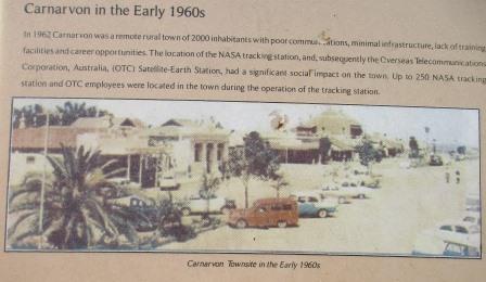
Information about Carnarvon's role in space exploration with a great photo of the town in the 1960s.


Further
along is another great mural showing what there is to see in Carnarvon.


In
the centre of the roundabout is a pile of sticks which I figure represents The
Fascine.

There
are heaps of caravan parks in town but I have only seen a couple of pubs.

We
drove out of town to follow the Plantation Trail which crosses the Gascoyne
River twice in its loop. Lots of sand and a few pumps bringing up the precious
water from below.


We
spotted tomatoes, asparagus, corn, eggplants, pumpkins, watermelons, bananas,
paw paws, mangoes, oranges, lemons and heaps of grapes. According to the
brochure capsicums, beans, zucchini, stone fruits, avocados and star fruit are
also grown here.
Found
a big something beside an old building which has a great mural of grapes
growing.


Back
across the Gascoyne River on the main highway.


As
we head back to town we spotted the big satellite dish where the Space Technology Museum is. Kerry and Brian said to
allow plenty of time there. The summer hours are less, 10am to 2pm so we will
check that out tomorrow.

Back
to the van for drinks and read our books for a while. No breeze now so got out
our fan to stir the hot air.
Steve
found some TV channels but there isn’t much of interest to watch on it any
case. Got a text from Ed, will meet him for a cuppa in the morning.
No comments:
Post a Comment