7am
26 degrees, clear sky and no wind. The wind stopped in the middle of the night.
Headed
off over the Lyndon River.

Stopped
for a photo as we crossed the Tropic of Capricorn.

Drove
past the turn off to Warroora Station homestead. They have 4WD campsite south
of the homestead too and along the coast up to 14 Mile Campground which is
suitable for vans and 2WDs.
A
goanna stopped in the middle of the road to let us pass then Steve saw in the
rear-view mirror that he continued across the road – what good road sense he
has.
Ant
hills start appearing – this one look like a face.

Turned
into 14 Mile Campground track. Stopped to let air out of the tyres and Steve
chatted with a family who were reinflating theirs. He said the track was a bit
bumpy but the sand was hard and you can camp right on the beach with the van.
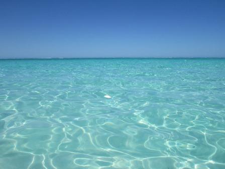
Lovely
view of the aqua sea of Ningaloo Reef, which is easily see with the white wave
line.

There
is campsite along the ridge but we wanted to be on the beach. Chatted with a
couple we met as we reached the beach at the caretaker’s camp. They said to
follow the track along the beach and we would find Barry the caretaker there.
Now
we are talking – beautiful calm day and clear, crystal water.


We
found him – he was leaving today so we just paid for one night @ $10 each. He
said someone from the station would call in every few days to collect fees.
This time of the year there isn’t too many people travelling so we could choose
any spot as there were only 4 other campers and two of them were leaving today
too. The posts marked the different camp sites.


Chose
our spot and set up camp then had a cuppa.

Put
on our togs and headed into the clear water. It was so clear and cool.


I
got out and got the camera to prove Steve got in.

Walked
out into the water with the camera – spotted a cuttle and one Dart.

Looking
back at the van – now this is luxury, until the wind blows of course.

Looking
around the coastline to the south.


I
found a couple of shells.


11am
the wind picked up from the west so the calm water was chopping up. Glad we got
to see it at its best.
Had
lunch – great view out the front window over the bed.

Headed
off to explore the other campsites. Back to the main track then north along
another sandy track beside a big sand dune covered in grass to Turtle Rock. Up
and over a sandy ridge in low range – all good, Steve said easier than on the
Canning Stock Route.


I
thought there would be a rock looking like a turtle so when we arrived we were
just on a flat rock. We wandered to the edge then Steve spotted turtles – hence
the name.

View
north to limestone shelves.


South
with the white sand.

There
were quite a few coming up for air occasionally. Managed to get a photo of one.
We also saw a big school of what we think were mullet.

Drove
back along the track passed the turnoff to camp and continued south. The
homestead is 23 km away. There is an overflow area for campers to wait until
there is a vacancy – first in best dressed which is good and everyone has to
have a chemical toilet. Obviously it is very popular if they need an overflow
area.
Stopped
to check out the posts which mark the north boundary of Pelican Point Sanctuary
– I think that is for fish not pelicans!

Looking
back along the beach the vans and our van on the beach.


Then
south.

Spotted
a cute chappy enjoying the sunshine.

Passed
the overflow area for people waiting for sites at Sandy Point. Drove on the
high side along Sandy Point beach and passed the turn off down to the camp
sites. There used to be track out the other end but they have now made it one
road in which could be a nightmare when it is busy.
Continued
on to the end of the track – on the Hema the track continues but it now closed
off. We walked up the dune to check out the view.

There
is another dune to cross before we reach the water.

Took
a photo through my sunglasses to compare.


Drove
back to the turn off and headed down to Sandy Point campground. There is a boat
launching area so I walked down to the water to take a photo. It smells of
rotting weed.


The 14 campsites here are back from the beach.

There
is only one camp spot taken here. Drove back up the track – nice view down to
the point.


Back
along the track to the turn off to the homestead. Next turn off took us down to
Pelican Point. Marine Park map shows where we are.

Walked
up around the sheoaks.

Looks
lovely but there are no pelicans. Should be called Urchin Point as the beach is
covered in them.


Steve
made a cairn of them. It stayed up for a moment.


We
wandered along the beach through all the urchins.


Found
some shells too.

There
was a big sand dune so I told Steve he needs to run up it like he did on our
honeymoon. There was a race on Great Keppel Island and he and Graeme went in
the race. Graeme fell coming back down taking out the other competitors so
Steve won the champagne – we never did open that bottle! He didn’t get very far
on this one.


As
we walked around the shore line we spotted a small shovel-nosed shark working
its way along the water’s edge. Found this crab hiding in the rocks too and
some funny slug things.


Getting
pretty hot and the wind has come up. This roo has the right idea – rest in the
shade.

Back
to the main track and continued south. Startled two bustards as we turned off
to Elle and Maggie Beaches where people can camp. Over soft sand ridges which
are on average 7 metres high according to the Hema.

Passed
the turn off to Elle’s Beach and continued north to Maggies through a narrow
valley between sand ridges. As we approached another ridge a sign warned to
watch for oncoming traffic – we went up and over and had to dodge 2 roos and a
joey – the sign was right.

We
pulled up beside a pole with a buoy on top marking a campsite. Put on the
kettle and I said to Steve we could sit up on the rocks in the shade but when I
looked it was full of kangaroos. They stood and watched us but didn’t want to
give up their shady spots.


Nice
bay. Someone has been collecting shells.


I
walked down to the water and along to check out a sign. Further along to the
point is a turtle nesting area.

I
walked along looking for turtle tracks – nothing. Looking back to the rocky
point.

Looks
nice with the sunshine shimmering off the water.
I
found my smallest abalone shell yet.

Drove
around to the south end of the camp area. The reef is closer here.


The
last camp spot was out a rocky point. Rocks one side and sandy beach the other.


Around
to Elle’s Beach – lots of camp sites but well back from the beach. Glad we had
our swim this morning while it was calm.


There
are still more campsites further south but we decided to head back to the van.
Spotted a couple of goats.
Checked
out the 14 Mile Ridge campsites too – nice view from here.


On
the way in to our camp area we took a track to more campsites behind the dunes.
Very sandy here – someone has been bogged recently. So glad we are on the
front. Off season might be windy and warmer but at least you don’t have to
fight with the crowds.
Stopped
to chat with a couple parked near the caretaker’s camp. They were waiting for
the caretaker so we let them know there wasn’t one at the moment so they
decided to stay right there. They had gone down the track we were just on and
were the ones bogged in the turn-around with their van. The chap was not
impressed.
Back
to our van – the lovely calm sea is very choppy now.

Had
drinks while we played a few games of Skipbo then I wrote some of my blog up.
Joined
our neighbours, John and Amanda from Brisbane for drinks as the sun sunk into
the ocean. Amanda is a nurse and had worked in Tully and stayed at Mission
Beach. The wind has picked up but we aren’t feeling any sand or sea spray being
blown onto us.


Chatted
away until it got quite chilly so headed back to our van with the glow in the
west and a star in the sky.

Late
dinner, 8pm 26 degrees with the wind blowing so we closed up the van.
No comments:
Post a Comment