6am
34 degrees, light breeze and mostly clear sky. Two years ago I was showing
Kaylene the sights around Margaret River – bit cooler there, max 23 and min 13.
Now we are 41 max and 34 min!
Took
a photo of our camp spot before heading off.


Across
Bow River – a few puddles of water in the rocky sections.


Balancing
rock on top of Mt Nyulasy. Near here is the turn off into the Argyle Diamond
Mine.


Much
nicer scenery with all the hills. Lots of horses about.


Big
boab in Marchfly Creek – doesn’t sound like a good spot to camp.


O’Donnell
Range to our left.

Passed
a couple of small aboriginal communities well away from the towns. They might
be more interested in looking after ‘country’.
The
mountains continue with grass and gumtrees.
Passed
Doon Doon Roadhouse. A fire is burning in the hills to the east.
Driving
beside a high range then we dropped down to 145m elevation onto wide flat grass
plains. Spotted some pandanus palms – Steve said now we are in the tropics.
Over
the Dunham River which is dry (111m elevation) (no photo) then a single lane
bridge over Arthur Creek.
Stopped
at a t-intersection – left to Wyndam and the Gibb River Road and right to
Kununarra on the Victoria Highway. We headed to Kununarra. Up and down some
rises then onto wide plains between two ranges. Nice view as we near Kununarra.
Plenty
of water in this section of the Dunham River.

Across
the Ord River Diversion Dam. Lots of greenery – even a house boat.


Past
the airport then over one of the Ord River irrigation channels.

These
boabs do look like bottle trees.

Into
town to fill up with diesel. The fuel app on my phone is really good.
Down
the road a bit to the Celebrity Tree Park by Lily Lagoon. A big water hole off
the Ord River. Had an early cuppa.
Drove
around the top end of Lily Lagoon as we headed out of town which looks nice and
clean.

Continued
east – 510km to Katherine, NT. Left the hills behind – back to grass and some
trees.
Fire
has burnt a big area either side of the road – nice green shoots in contrast to
the black tree trunks.
Back
into rocky hills. Clear sky. Passed the turn off to Lake Argyle.
Big
hill ahead as we reach the border. Farewell Western Australia – will be back to
finish off the top end one day.

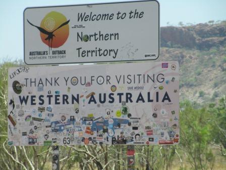
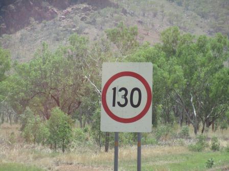
Into
Northern Territory. Steve went ‘Get real’ when he saw the 130km/h speed limit.
To start with they need to upgrade the road!
Must
have rained recently as the little creeks have water in them. Open grass/tree
cattle country and lots of big boabs.
Nice
escarpments. Went through a willy willy which showered us with dust and leaves.

Slowly
descended to 15m elevation as we pass through lots of flood plains. Water and
ducks in King Billabong near Bulla which is an aboriginal community.
Three
donkeys were enjoying the shade of a big boab as everything else is burnt.
Passed
the turn off up to explorer Gregory’s cairn and tree in the top end of the
Judbarra/Gregory National Park. There are gorges to explore around here.
Someone
has put climbing rungs up the side of this boab.

Pulled
into a parking area beside the Bradshaw Bridge over the Victoria River. Across
the bridge is the Defence Training area called Bradshaw Field (named after the
station there) which covers a big area north of here. Checked out the river
(downstream then upstream) – can’t see any crocodiles. From here the river
flows out to the Joseph Bonaparte Gulf above the WA/NT border.


A
quick lunch in the van, 42 degrees.
Lots
of lookouts etc to explore later. Continued on to Timber Creek. A little place
with police station, van park, houses and roadhouse. There is a history trail
so will have to check it out later.
A
narrow bit of the Victoria River.

Nice
scenery.


Passed
the turn off the dirt Buchanan Highway which goes south-east and across to the
Stuart Highway. We had thought of going this way to cut off a few miles but
didn’t want to chance the dirt roads with the storms about which are building
ahead of us. Steve is talking to the clouds to give us a good shower of rain to
wash some of the salt etc off the truck and van.
Forgot
to check the elevation at Timber Creek but we have climbed to 103m as we head
east.
Slow
climb up through the hills to 160m then continued up and down hills. Sharp drop
down to 46m at the east section of Judbarra-Gregory National Park. A big sign
warns of crocodiles so no swimming in the river.
Checked
my phone and it has changed to Northern Territory time so at 1.50pm WA time it
is now 3.18pm – time to stop for a cuppa!!
Back
near the Victoria River again. Escarpments are nice and a few gorges appearing
as we run along the edge of the river.
Across
the Don Darben Bridge over the Victoria River near the Roadhouse – who stole
the water. The rivers’ upper reaches are south of here and start near Riveren
Station (off the Buntine Highway) that I read about in Terry Underwood’s story
of her life (In the Middle of Nowhere) with her husband on that station. It was
an amazing read. I would love to go there one day.


Big
escarpment has tall palms on the side like the ones we saw at the Bungle
Bungles – I think they were Livingstone Palm.


Steve
is excited – his chat with the clouds worked. Enough rain to put the wipers on
normal speed but it didn’t last long.
Another
shower as we left the National Park area. The ant hills here are little black
mounds.
Elevation
up to 224m then we drop down to 178m as
we cross Brandy Bottle Creek which had some water in it. I wonder what story is
behind that creek’s name.
Passed
the turn off to a cairn and the Buchanan Highway which goes south-east and
across to the Stuart Highway. We had thought of going this way to cut off a few
miles but didn’t want to chance the dirt roads with the storms about.
We
could smell the lovely ‘rain smell’ as the water hits the pavement but then it
was replaced by smoke. We couldn’t see anything but could definitely smell it.
Dark
cloud out front had a big flash of lightning go across it. I kept staring for
more but no more flashes.
Stopped
for a cuppa on WA time. Will change the clocks over tonight then start tomorrow
on NT time. Sat outside as the recent showers of rain has knocked the heat out
of the air so it was cooler outside than in the van. Chatted with a couple from
Darwin heading across to the Bungle Bungles, Kalbarri and Coral Bay with their
3 daughters – the littlest was eyeing off the muddy puddle nearby.
We
continued north-east towards Katherine. The anthill t-shirt brigade have been
here too.
Spotted
a couple of wedge-tailed eagles – NT ones.
Last
time we were in Katherine was 27 years ago when Daniel was 3 years old. We
filled up with diesel at the United Fuel place. The chap asked if I had a
Woolies card which I did and he gave me another 4 cents off which was very
nice.
Continued
along the Stuart Highway south. More lightning flashing in the dark clouds
ahead of us. Some very big flashes too and then some drops of rain.
Steve’s
storm chasing worked as we are driving straight into it and the heavy rain came
down. That should cool things down in the van.
A
massive lightning strike straight in front of us – as long as it doesn’t hit us
I think it is marvelous to see.
Pulled
into King River South Rest Area to park up for the night. No one else is here
so we parked to the back near a water tank. Lots of birds are tweeting after
the rain. Opened up the van, 32.8 degrees, yeah. Just light enough to take our
camp photos.


5.30pm
WA time therefore drinks time, though that is 7pm NT. Will mean we will lose an
hour and half sleep time as we will set the clocks and get up in NT time.
Nice
and quiet – only a couple of trucks have come by while we watched a movie after
dinner. Had to pull out the fan though as the coolness has gone and now it is
hot and sticky.
No comments:
Post a Comment