6am
31 degrees, clear sky and a slightly cool easterly wind. 1am the wind started
up again which was nice to stir the hot air. Definitely not nice sleeping
temperature and the fridge isn’t happy at all.
7am
headed off – stopped to check out the signs at the bitumen rest area.


Lots
of dead cars around the old homestead. Across the road is the Barradale Sand
Mine.
Continuing
north-east passing piles of boulders which are appearing on the flat plains.

The
wind is on our side again. Sky filled with dust from the dry easterly. A couple
of flat topped hills covered in spinifex near the road with a range of hills to
the north and east.
Across
the dry Ashburton River. Passed the turn off to Newman. Parry Range on the
right.

Entered
the Cane River Conservation Park – no information about it – open red soil
country with spinifex and low shrubs and trees.
Turned
west for the 82km drive into Onslow on the coast. The sign said it is ‘The
Cooler Coast’ – we hope so.
Passed
a limestone mine. Further along big red ant hills are everywhere.

Slowed
for roadworks 110, 80, 60 then back up again so only get to slow down again for
another set of signs. Honestly I think they used everyone the shire owns
because there were hundreds – up and down with the speed – really!! You would
think they could just finish one spot and then work on the next – what a mess.
As we approached a gravel section which had bollards on each side a water truck
that was heading towards us. We pulled to the left so he could pass as he was
in the middle of the road – not that easy with the van on the back – then he
decided it would be a good time to water the road. We then had to swing across
to the right so we didn’t get wet or had to drive on the wet muddy road –
really!! The sign said the roadworks were funded by the Government and Chevron
Oil & Gas and would be finished by Feb 2020. The way they are going I don’t
reckon that’s going to happen.
Nearing
Onslow we started crossing salt pan areas which are now condenser ponds for the
solar salt company here. Onslow Salt field occupies 90 sq km of salt flats,
with seawater pumped by three pumps at a maximum rate of 4,000 litres/section each
for approximately 18 hours per day depending on the tides. Onslow Salt Pty Ltd
is capable of producing nominally 2.5 million tonnes of sodium chloride per
annum. Crossing the causeways between the ponds.


Zoomed
in on the Onslow Salt pile ready to load onto the conveyor which will take it
to the ships at the jetty. There is a bulldozer up on the pile shoving the salt
around – I bet they rust out quickly.


Into
Onslow and down to Sunset Beach for a cuppa. There is a point here so you can
see the sunrise on one side and the sun set on the other.
Very
hot so opened up all the vents and windows while we had our cuppa. We like
warmer climate than cold but this is getting a bit too uncomfortable now.
Rang
Mum for a chat and was saddened to hear that Dad had deteriorated. He got an
infection in his leg which is quite swollen and sore and it has made him very
confused etc. Very hard for Mum with her condition and weak back. In tears
Steve and I chatted and decided that the heat wasn’t making sightseeing very pleasurable
and as we had decided to leave the Kimberleys till another winter, when they
have had a good wet season, we decided to just start driving for Cairns. I rang
Mum back and said we are on our way and would be about a week. Mum also
mentioned there had been a terrible tragedy in New Zealand where tourists etc
had been killed and burnt when a volcano erupted. Clive and Rebecca were
heading to NZ but I don’t think they would be there as Ingrid is in
Christchurch. Very sad for the ones burnt and the families of those who have
lost their lives.
Put
on our hats and followed the Ian Blair Memorial Walkway around to Beadon Point.
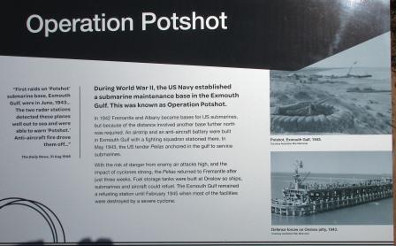
Amazing
to read about the atomic bomb explosion near here in the 1950s.

Info
about wildflowers and a photo of the bird flowers – only dead stalks here now.


A
ship is in being loaded with salt. The jetty is approximately 1.3 kilometre
steel trestleway.


More
information boards.


Zoomed
in on the Wheatstone Gas Plant in the distance – looks like a ship is being
loaded there too.


Info
about Ian Blair who gave so much to the community of Onslow.

More
info.


Amazing
to read how the reef and fish around Montebello Island have recovered so
quickly after the atomic bomb there in the 50s.

Very
interesting reading as we wandered along.


The
‘new’ jetty that started the move from Old Onslow to here. Now that jetty is
nearly gone.


A
couple more boards then we reached the park.


The
War Memorial (erected in 2008) depicts a Diggers Badge and has been designed
for the sun to rise through the centre each Anzac Day.


A
big rock is a memorial to the crew of two ships lost during Cyclone Bobby in
1995.


The
beach.


Nice
directional plaque.


Now
for a quick 1017 metre walk back to the truck and van.

There
is a nice park here too.

Onslow
is another great place to see the Staircase to the Moon between April and
October. Got this photo out of the brochure.

Drove
around town. Onslow is the oldest town in the Ashburton Shire. Good town map.

Found
the old Goods Shed which is not a museum (not open in the summer though). The
building was moved from Old Onslow in 1925.


Drove
to Beadon Creek where a barge had dredging equipment on board. Further over is
one of the drilling platforms. A big thing outside the dredging company’s
premises.


The
other side of the town map is the regional one.

We headed back out of town to
the Old Onslow turnoff – working our way back through the road works. Onto a
dirt road past the turn off to 5 Mile Pool and 10 Mile Pool which are day use
only areas beside the Ashburton River. This area is a privately owned cattle
station but they do allow camping at 3 Mile Pool for self-contained vehicles.
The cattle think it is a good spot to hang out too – plenty of shady trees by
the river.

Continued
on to the Old Onslow Townsite. The site was proclaimed a town in 1883 and named
after Sir Alexander Onslow, the acting Governor and Chief Magistrate of Western
Australia at the time.


The
old sea jetty site is within the lease of the Wheatstone Gas Plant.

Not
much left but there are lots of information signs to read. Very hot here so we
just drove around and I jumped out to take photos then back into the air
conditioning.


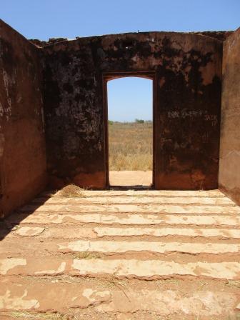
Got
out at the site of the old Police Station as the buildings here have had some
stabilising etc. Great aerial photo from the map.


The
old water tank.

Much
cooler inside the cell. Bolt on the floor to tie the prisoners too.


No
roof on the other building.


Across
the road was the church hall.

Bigger
sign for the man who established the port here in 1882/3 and built the jetty.
He also had a general store and a pub, of course.


People
have been collecting some of the old bits from the store. The Hopes also had a
pub. Imagine coming here and starting a business etc. Makes you really
appreciate our pioneers.


Continued
down the sandy track – still with the van in tow. Info about the aboriginal and
Japanese pearl divers.


Reached
a turn-around area and stopped there. Don’t need to get stuck in this hot sand.
Walked along the ‘street’ to read the info about the old jetty.


Walked
the other way down to the Ashburton River. Quickly took a photo as the
sandflies found us.


Back
into the truck and back to ‘town’. The old water tank is not looking too good.


Drove
back to 3 Mile Pool where there is a causeway for the station across the river.
Workers are creating a new causeway upstream a bit.


We
found a tree to park under so we could make our late lunch and cool the van
down – well that was the hope but it didn’t happen.

Looking
up then downstream of the Ashburton River.


Headed
back out to the main road and then through all the road works again back to the
main highway. Clouds are building and then a few drops of rain hit the
windscreen.


Snapped
a photo of Bobby’s Tree. The inscription reads – This tree is respectfully
known as “Bobby’s Tree”. Bob McAullay, a Shire grader operator from 1969 to
1980, nurtured this tree in its infancy and in recognition of this, the Main
Roads Department and Shire Council ensured that the tree remained when the
Onslow Access road was aligned and sealed. Hopefully it will survive the latest
road works.

The
limestone quarry was being worked and there were clouds of dust floating across
the sky.
Reached
the highway then turned south back to the rest area. Made a cuppa and watched
the storm cells come across. Heard rumbles of thunder and even saw a flash of
lightning.


Now
for the long 5000 odd kilometre drive home to Cairns. Continued north through
the rest of the Cane River Conservation Park.
Passed
a man-made hill complete with dump truck adding to it. Sign said it was Mesa A
Mine – iron ore.


Crossed
Robe River – dry of course. There is a big rest area here too.


The
road is wet as we pass the turn off to Pannawonica. Will return to explore it
and the Millstream/Chichester National Park another time.
Red
dirt, hills and spinifex continue.
Crossed
the Fortescue River on a long bridge which was built in 1973. A little pool of
water.


There
is heaps of demountables beside the Fortescue Roadhouse – probably for the
mines but they don’t look in use now. The hills are burnt and it goes on for a
long way.

Sino
Iron Mine Site cross roads with the camp on one side of the highway and the
mine on the other. Lots of cars about, must be shift change.
Devil
Creek Gas Plant near the turn off to 40 Mile Beach. Named after the creek which
we drove through soon after.


Dark
clouds staying on our right but no more rain.
Flat
open country covered in grass with lines of bright green from the creeks full
of gum trees. Hema Navigator says we are travelling beside an underground pipe
carrying gas from Dampier to Bunbury.
Miaree
Pool on the Maitland River. There are two 24hr rest areas here.

Past
the turn off to a pastoral lease called Karratha Station – which came first the
town or the station.
Supagas
Gas Plant.


Back
into hills on the right side and flat country on the left leading down to salt
flats as we near Karratha.
Topped
up the diesel tank on the highway before the turnoff into Karratha and Dampier.
Looks like a lot to see and do around this area when we return.
As
we continued a heap of quartz walls appeared in a row.


A
very long train carrying iron ore passed under us as we drove on the overpass.
Drove
through Roebourne – nice little town with lots of history. The sun is getting
low under the dark rain clouds.

Passed
the north turn-off down to Millstream/Chichester National Park. Continued on to
a roadside rest stop just before Jones River for our camp for the night.
Lightning is flashing around us. Flat open grazing country – no trees. A range
of hills is on the right.


Fabulous
lightning strikes across the sky as we had dinner then watched a movie with all
the windows and vents open. Fairly quiet which is good as we are beside the
road.
10pm
still 35.8 degrees with a bit of a breeze starting.
No comments:
Post a Comment