7am
25 degrees, clear sky over the sea but there are clouds building
east/south-east of us. Still blowing hard. The tide is out showing the moss the
fish were feeding on.


Steve
spotted two vehicles on the far side of the bay. One appears to be bogged. His
mate continued on then came back, passed the bogged car then came back to the
track entrance, turned around and went back to his mate. In the meantime that
car had gotten going so they both continued along the beach heading to the
point. Then we spotted another car there and then the three cars disappeared in
front of the big rock cliff – obviously there is room to drive as it looks like
the waves are crashing straight into the cliff from this angle. We didn’t see
them return so there must be a track back out.
We
packed up. When I looked in the leftover wash water I saw a dead field mouse!!
Obviously he was after the water. Hope none of his friends climbed into the
truck!
Back
to the blow holes – no water around them so they didn’t blow last night.
Spotted a big mouse in the sand dunes – a kangaroo.
Headed
out to the main track and turned north. A small brown snake slithered across
the track. Back into high range again along the wider track.
Clough’s
Bar came into view. It cuts across the inlet as part of the salt mine
operations. Will have to Goggle some more information about it.


Drove
to the end of it – big ‘no entry’ signs and a gate.


Now
for the climb up and along the side of the big sand dune. First bit quite
corrugated but ok.

Stopped
at a pull-off spot for a great view over the bar and water, down to where we
crossed it at the causeway.


A
bit further along we pulled off again as the big white dunes appeared so I had
to get a photo of course.


Wobbly
descent with the corrugated track – will be fun going back up it when we leave.
Track
continued on harder ground with the white dunes on our right.


Next
dunes are creamier in colour.

At
the intersection we turned south towards Thunder Bay which has blow holes too.
Very soft sand as we went over the last dune to a look out. Took a video.

Lookout
view.

Up
and over another hard dune for 1 km to the blow holes. Another vehicle has
joined us.
Found
the sign, now where are those blow holes.


We
heard a roar – they are over past the life buoy.

Lots
of holes here. This tiny little one is making all the noise though.


Looking
down each of the holes – little roars coming from a couple of them and a bit of
mist came up the second one which I got a video of.


This
little one was making the most noise and the wind blowing out was quite strong.
A couple back had Hamelin Pool mentioned it and said not to put your hand over
it as when it sucks back it sucks your hand hard.

Chatted
with the young couple who are from Wollongong, NSW. They gave us their jobs to
travel for a year but have a house which they have been able to keep rented so
that covered the mortgage. They are loving travelling with their camper trailer
(parked beside our van at Hamelin Pool apparently) except for the flies. They
had planned to do overseas next but they reckon there is so much more they want
to see in Australia first. We recommended doing the Canning Stock Route and
spending months in Tassie rather than weeks.
We
had a cuppa and enjoyed the view.

Climbed
back up to the track and continued along heading north. Sea spray mist is
making the views hazy. Stopped at Dicko’s Lookout on the top of a sand dune.
Indian Ocean to the left, track to Steep Point then Blind Strait and the white
dunes to the east.


19km
to Steep Point. The track travels close to the edge of the cliffs in some
parts.

Saw
two vehicles so pulled in to see if the men were fishing. Couldn’t find anyone
– hope they are ok. Steve has read how these crazy fishermen will climb down
the cliff faces to fish off the rock platforms.


Further
along we spotted the Nor 6 monument on the top of the cliff.

Drove
around to it – info about the Zuytdorp Cliffs.

Walked
up to the rock cairn and memorial erected April 2007.


Amazing story. On April
25, 1963 the brand new prawn trawler, Nor 6, crashed on the rocks below this
spot at 5.30am in the early morning darkness. She was immediately overwhelmed
by the surf and rolled over and sank in less than a minute. Her crew, Barry
Allen, Ron Poole and Tony Romonostro were all drowned in the accident. Her
skipper, Jack Drinan, aged 38, had been off-watch was flung clear by the first
wave. He climbed into the trawler’s brine tank or icebox which had floated
clear on the backwash from the waves. At the time the Admiralty Chart of the
area was incomplete. It dated back to sailing ship days when HMS Herald made a
survey of Shark Bay in 1858. In 1963 the chart showed only a dotted line along
this section of cliffs, indenting considerably to the east. Other causes were
the overhead riding light reflecting on the foredeck and back onto the
windscreen obscuring the helmsman’s view into the night. If the Nor 6 had been
half an hour later in her departure she would have been off this point in the
daylight and the cliffs would have been observed in time. A massive sea and air
search over several days failed to find any trace of survivors. By the time an
aircraft finally sighted the wreck Jack Drinan and the icebox had drifted far
out to sea. Police divers swam down to the wreck but could find no sign of the
crew and it was presumed that all had drowned. Meantime Drinan was making a
remarkable voyage. His raft was blown on easterly winds. He broke off a metal
fitting and carved a hole in the icebox to gain access. Then he survived on the
crew’s food in the icebox and the freshwater from the melting ice. Eventually
the wind changed and after 14 days adrift reduced to drinking seawater in the
end, he was blown back to the coast close to the spot where his journey had
begun. He had carved a surf ski and a paddle from the icebox lid for when he
got close to land. He managed to launch it and paddle into South Passage around
Monkey Rock. While crossing the passage to Dirt Hartog Island he was picked up
by the fishing boat Sonoma, and the news of his survival was radioed to the
world. In Carnarvon, the destination of the Nor 6, he was greeted by his wife,
Jean, family and friends, who for a fortnight had believed he had drowned. Now
he was welcomed as a man back from the dead. He continued his sea-going career
and died of cancer in Perth aged 61 in 1986. Some years after the Nor 6 tragedy
his brine tank, covered in barnacles, washed up in South Passage, returned by
the sea.
Looking
out to sea and down to where the Nor 6 wreck is.


View
north – 8km to Steep Point.

Steep
Point – the most westerly point in Australia. 3 points and the centre done,
only Byron Bay to go.


Of
course the land goes out further. A boat was out there so I gave them a wave
and got a few waves back.


Looking
across to Dirt Hartog Island.

Another
selfie on the edge.

Walked
back – looking down on ‘The Oven’ campground where the balloon fisherman are.


Another
couple pulled up and offered to take our photo then I took theirs.

Signed
the visitors book. Someone left a rock from Byron Bay, most easterly point.


Looking
at the map on the sign and the Hema it looks like the lighthouse is actually
further west but we will go with the sign here.


Very
windy here. Headed down to the campground to chat with the guys we met at
Hamelin Pool when we first arrived. One chap showed us some photos on his phone
which I photographed – 15kg Spanish mackerel, Cobia and of course they lose a
few to the sharks. They sent home 19kg with their mate and have got a further
22 kg in fillets so far. 20kg bag limit each person. They use big whole garfish
as bait and a helium balloon to hold the bait on the surface. As the balloon
moves it skips the bait across the water.


Chatted
for a bit then we went to the edge to watch the balloons dance. No action at
the moment other than a Buffalo Bream annoying the boys’ bait.
The call went out as the blue balloon hit the surface and didn’t come up. I got a couple of photos of the mackerel as he pulled it in then took a video of him lifting it up the cliff edge using a rope gaff. Slides down the line then opens up at the end and clamps around the fish so they can pull it up safely. These guys are well set up with a pump to bring up sea water for the filleting table.


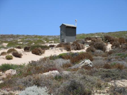
The
boys camp by the rock ledge to give them some wind protection.

There
is a loo with a view.
Had
lunch in the shade of the truck then drove around the point a bit to the next
campground called Faultline. The rock ledges are closer to the water of South
Passage. Some fish in style but no action happening here at the moment.


Looking
across Monkey Rock to Dirt Hartog Island, which is a National Park too.

Down
South Passage towards Shelter Bay.


Faultline
campground.

Drove
back out then down the east side to Shelter Bay. We met the Ranger grading the
track so we backed up to let him pass.

Pretty
blue as we crest a dune – looking down on Sandy Point. Note the limestone edge
further back.


There
are campsites all along the beach. No protection from sun or wind. We had
chosen the very end one, Blackies, as someone said it was a good spot to get
whiting.
First
we stopped at where the barge leaves from to cross to Dirt Hartog Island. With
it this windy I am glad we aren’t spending the $400 to go across.


Looks
nice here.


Continued
along the track then over the ridge where the rocky point was and turned down
the track to Blackies.
Looks
like we can camp on the beach.


Looking
back to the point where another camp is set up. Some guys are out fishing off
the rock.

The
wind has picked up so we tried to park using the shrubs to provide some
protection. Unfortunately the sand was a bit too soft. Out with the ‘Treds’ and
we moved spots.

On
the other side of the shrub the ground was harder with limestone rock so we set
up there using the Treds as a levelling ramp.

The
wind got stronger and is blowing straight down the sandy track. We put up the
shade cloth to try and block it.


Steve
walked over the rocky hill while I went for a wander in the water around the
rocks. Can’t see any whiting in the shallows.

Zoomed
in on the southern point of Dirt Hartog Island.


Had
a cuppa as the wind got stronger. We are getting covered in sand so we decided
we didn’t need to sit here and put up with it so we packed up and left. Knowing
how the wind doesn’t die down in the evenings it wasn’t worth sitting here. We
have ticked off the most west point, seen a mackerel being caught by the
balloon rock fishermen so we were happy to leave.
Drove
past the ranger station that was on the other side of the ridge from our camp
spot. It is in the hollow between two dunes.
Further
along was a brick home and shed which had a sign saying it was a private lease
– nice for some. By the pile of blocks it has only been built there recently.

The
track continued right along the edge of the beach. We spotted some little
whiting in the shallows but decided it was too windy to even try even though
the water looks calm here.

Inland
for a bit then down the edge of Blind Strait and back through the white sand
dunes. Climbed back up the steep dune – all good in low range.
Goats
everywhere when we stopped at the causeway so Steve could put some air back in
the tyres.
Back
to our van about 6.30pm. Paid the owner for the night storage and tonight to
stay. She has been here 8 years.

Aerial
photo of Steep Point to the right, with the track leading down to the
campgrounds, The Oven and Faultline on the left. (oops it turned sidewards - still haven't figured out how to change it on the blog page.)

Cooked
dinner then enjoyed a nice shower to wash all the sand off us. Will unpack the
truck tomorrow. The wind is still blowing hard but we are nice and cosy in the
van.
No comments:
Post a Comment