6.30am
26 degrees, clear sky. The wind blew all night and is still blowing. The tide
is out as we can now see a sandbar in the middle of the lagoon.
8am
packed up and on the move. A few clouds are appearing – weather forecast sad
the next two days to be cloudy.
Back
out the 10km to the main track then turned north. Spotted our first kangaroo.
Of course he left it till the last moment to bounce across our path to the
other side of the track!


Pulled
off to check out Krasker’s Tank. Ingenious tank but a sad story about Mr
Krasker. Dying of thirst would be my 2nd worst death – 1st
being to be burnt to death.


I
am getting good at identifying animal tracks. Emu, emu chick, goanna and I
think one was paw prints – someone has snuck their dog into the national park!


Continued
on the straight sandy track rolling up and down the sand hills.

As
we crested another sand hill I could just make out the north edge of the Big
Lagoon.
Past
the turn off east to Herald Bight. Will check that out later as it might be
more sheltered than the west side for camping.
Around
the edge of a big clay pan called Lake Montbazin (on the Hema). There is a flat
clear section which would make a good airstrip. There is a fence around it to
keep the ‘human ferals and their 4WDs’ off it. Didn’t stop them doing donuts on
the side of this track.


Back
into the soft sand just before the turn off into Cattle Well. No information
why it is called that as it was sheep they raised up here. Steve had let out
some air (20F & 30R) but obviously not enough and the tyres had heated up
adding another 5psi to the tyres. Definitely wouldn’t be bringing the van any
further with this soft sand.


Tyre
pressures lowered (15F & 22R), backed up and off we went again easily.
Narrow track in – this is a fishing spot, no camping allowed. Red sand leading
up to a white sand hill.
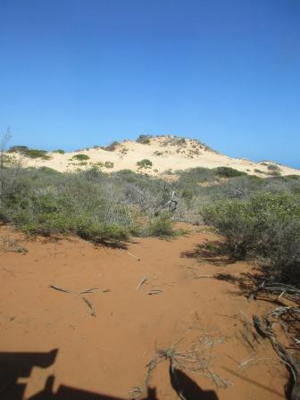
Creamy
on the other side and whiter sand on the beach.


Lots
of birds flying about. Looking along the beach to the north end.


We
found some pretty shells.


Back
to the main track – very soft section next but we got through that easily. It
is also very bouncy with the corrugations hiding under the sand.
Turned
into South Gregories campground. Open bay type campsites. No one camped here at
the moment.

Walked
down onto the rocky foreshore.


Steve
spotted a turtle pop his head up for some air a few times but when he called
out to me he disappeared. I spotted a small manta ray then the turtle popped
his head back up.


More
soft sand as we continued up the track to Gregories Campground.

The
day use people get a nice picnic shelter and BBQ so we used it to have our
cuppa. No one camped here either.
Another
car arrived with a family. We walked down the boat launching ramp and chatted
with them by the water’s edge. They are from Melbourne and are enjoying a 4
month trip with their 3 sons and one daughter – her name is Ella. They came up
the centre of Aust and are working their way back down the WA coast. They had
towed their van into Big Lagoon and had to keep letting the tyres down as they
got bogged.

Still
rocky along the slope but beach is sandy.


Zoomed
in on the point further north then the next point which is a big white sand
dune with red sand escarpment before it.


We
watched as a big school of little fish (herring?) is being circled by some
little sharks. Saw a few big mullet swim by too.

The
water is lovely and cool but I don’t want to get all salty so will skip a swim.

Checked
out the two camp areas here then headed on to the next campground called Bottle
Bay. Again no information about the names of the campgrounds.

There
is one camp here and the three chaps were on the beach trying to catch some Pink
Snapper. Chatted with one guy (they are from Bunbury) who said they had some
fun trying to bring their trailer in – got bogged a lot as it was loaded up
with freezer etc. They haven’t had any luck with the fish as yet.


The
wind is getting stronger. The campsites here are back behind the sand dune so
no sea views here.
Continued
on to a Y junction and headed left to check out Cape Peron. Information about
the Leeuwin Current.

Red
sand dunes reach down to the hard rock shelf just before the water’s edge.


Steve’s
turn to try out the water. He stood too long and a wave got him.

We
walked around the point checking out the caves along the way.


Wide
sandy point with the hard rock ledge being covered in soft sand that was being
blown up in the wind.


A
sting ray swam by.

The
photo doesn’t show it well but this is where the ocean and bay waters meet.
Choppy to the left is the bay water and calm on the right is the ocean.

Further
along is Skipjack Point which has a boardwalk.

Lots
of cormorants here.

Walked
back around the point. Took a photo through my sunglasses (first photo) – does
make a difference.


Climbed
up the back side of the dune to check out the view from the top.

Information
about the cormorants and tiger sharks.

The
Melbourne family were below – the kids were having fun sliding down the sand.
You can see the line where the bay and ocean waters meet better from here.


Looking
back over the white sand dune then the red one closer to the water.


Pretty
white bush.


The
map showing Cape Peron and Skipjack Point and a great aerial photo with Cape
Peron on the right front and the Point on the left.


It
is warming up but the sea wind is cool. 34 degrees in the truck when we got
back in it. Drove back along the track and took the other track up to Skipjack
Point. Made lunch then realised there was no shade shelter here. Walked along
the boardwalk till we found a chair with a fabulous view and ate our lunch
there watching the black manta rays slowly swim along below us. Used the
monocular that Daniel gave us years ago. Too hard trying to take photos of the
‘fish’. The Melbourne family caught up with us and the kids had fun trying to
use the monocular.
Looking
around to the south then over the navigational beacon.
Continued
along the boardwalk to the two lookouts.

Lovely
view.


Though
the smell wasn’t nice. We realised it was from the cormorants lining the edge
of the water below us.

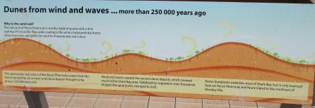
Great
information boards. The limestone we see is called Tamala Limestone.


We
are hoping some dolphins will come and round up the fish here.


Lots
of different fish to keep an eye out for.


We
all had fun pointing out the different fish, turtles, rays, sharks etc that
were swimming around. These five seem to be doing some synchronized swimming as
they were in a straight line then in a circle. Steve spotted a brown body
further out in the dark sea grass area and we all looked and agreed we think we
saw a dugong.

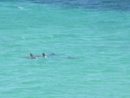
Then
we spotted some dolphins. Unfortunately they didn’t come in to round up some
dinner.

Headed
back south 22km to the turn off to Herald Bight to check out the campsites
there. Back around the base of the big salt pan – shimmering now. Passed an old
water tank (16 Mile Tank) from the pastoral days as we headed east along the
track.


Down
onto the beach – informal camp sites here. Yeah – anywhere you like along the
beach apparently.


We
drove past to vehicles parked by the water and stopped to chat with a guy
fishing. They were internationals so didn’t know much about the fishing. It was
very shallow so we drove further around the bay. Checked out the site of the
old fish canning company. Herald Bight was established first as a pearl camp in
the late 1880s – I had noticed lots of broken shells on the beach.


We
continued around the bay but the water got shallower – looking back to the
other campers.


It
was still windy here and there was more sand to blow up on us so we decided to
head back to Gregories campground hoping we might get some whiting there in the
shallows. Back along the track – looks similar to when we were on the Canning
etc, up and down dunes and around salt pans.

Steve
is enjoying all the sand driving.
Chose
the closest campsite to the toilets and shade shelter as we will use the BBQ
tonight. Put out the solar water bags for a shower tonight.

Some
other people were visiting and were on the point having a fish.


As
I was making a cuppa I heard a strange noise then looked up to see a drone
above us – so much for the ‘no drones’ rule in National Parks.
I
can see the Skipjack Point Beacon from here.
Steve
got the fishing rods prepared – we will try tomorrow, hopefully the wind will
ease off a bit.
I
went for a walk around to the point – the fishermen have left. Lots of Tamala
Limestone here.


Lots
of little birds too.


Plenty
of dead sea grass. Have to watch where we walk in the water too as this area is
reknown for stone fish.


Around
the point the limestone continues. The white stuff on the rocks area oysters.


Back
the other way – I felt like I had walked around to Bottle Bay camp as I could
see the white cliff but there must be another bay between us. The wind was
pushing me along. There was only one area clear of the limestone rocks to be
able to fish from and there is a bank of sea grass out from it so I think that
will be a good place to fish tomorrow.


Pretty
shell fossil in the rock.

Turned
back and walked in the water as my legs were getting sandblasted. Met Steve
below our camp. He had seen a small shark and a turtle where we had seen the
school of fish this morning. We walked headed around to the point. I stood in
the water for a bit to wash my legs and spotted a nice size Blue Swimmer Crab.
He had seen me as he had his claws out trying to make himself very big.
Another
vehicle has pulled in for the night – right down the other end. Steve checked
out the BBQ and gave it a clean ready to cook dinner tonight. Took our drinks
over to sit out of the wind (well a bit) while we watched the waves roll in.
Spotted some sharks cruise around as the tide has come in. One shark was quite
large (1.5m) and bronze in colour.
Another
4WD came in, parked in the next bay, then pulled out, drove down to the next
area, turned around then came back and parked in the next bay over. He then
walked out to the oysters with a bucket and hammer so we know what they are
having for entrée tonight.
I
heard some bleating and realised there was a goat somewhere. Eventually I
spotted it out on the point having a drink.


It
walked back around the beach then up on to the top of the dune near us. It just
stood and stared. Eventually it walked back down the beach and below us. Steve
said ‘neigh’ and it answered him but when I tried to get a closer photo it got
startled and bolted off into the bush.
Now
I know what is leaving these tracks.

Steve
spotted a little fairy wren flittering around.


Had
a sponge bath with the solar water as it wasn’t quite warm enough for a shower
and the wind is still blowing hard.
A
band of cloud is blocking my sunset (6.50pm).

Used
the BBQ for dinner and ate it in the shelter. Dug out the flannelette shirts as
it is quite chilly now. The Beacon is flashing in the distance. Sat out behind
the truck out of the wind and watched the stars come out and spotted a few
satellites before we climbed into bed with our books. Steve is enjoying all the
books I got for him in Mandurah. Nice listening to the waves on the beach too.
No comments:
Post a Comment