7am
24 degrees, clear sky and cool breeze. Nice photo of the Ningaloo Coast off the
NPWS guide book. The Ningaloo Reef is 300km long and one of the closest corals
reefs to land in the world and is Australia’s longest fringing coral reef.

There
is something to see here all year round. Swimming with Whale Sharks (March
–August), Humpback Whales (June to November), Manta Rays (year round), Turtle
Nesting and Hatching (November to March) as well as all the areas to snorkel
and fish.
We
headed south to check out Yardie Creek Gorge before the day warmed up. At least
there is some shady trees for when we return to have a cuppa. Big hats and fly
nets needed today.

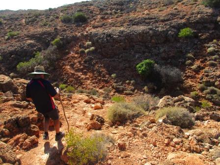
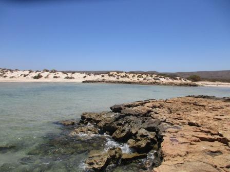
Headed
up the walk along the side of the gorge and Yardie Creek. It is the only gorge
in the area with permanent water which is salty as it is fed from the ocean.


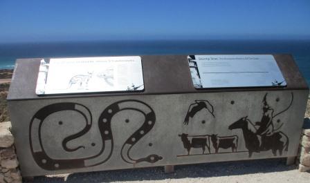
Detoured
off the track to check out the information board.


Looking
back to ocean and the sandbar stopping the creek from reaching the ocean. Then
up the gorge.


Mangroves
and spinifex.


More
info about birds and animals to watch out for.


Looks
like a line of oysters on the wall edge.


Continued
along the track and up the hill – nice view across to the waves breaking on
Ningaloo Reef.

Island
and the bend in the gorge.


Continued
up and down the hills following the white poles.


Across
to the other side of the bend looking upstream then back around to the bend.


Further
along I got a better shot of the next bend – end of the lagoon.


Continued
on till we could see up the next section of the gorge.

Steve
spotted a cairn on the next hill then noticed a wedged-tailed eagle perched on
a tree.


The
wedgie watched as Steve added another rock to the cairn.


Spotted
a wallaby but I can’t see his feet to see if he is the black-footed rock
wallaby mentioned before.

Walked
a bit further around for another view up the gorge as it winds its way into
Cape Range.


Great
view back around to the ocean.


The
information before mentioned that this break in the reef allows the creek water
to flush out into the ocean when floods occur etc and this opening was once the
mouth of the creek when the sea level was much lower.


Mr
Wedgie never moved so we left him be and headed back. Met a couple on their way
up so told them about the wedgie and the rock cairn.
Made
our cuppas then walked around the picnic area to the entrance on the other side
– someone didn’t think that out when they put in the car park. The track that runs
beside the picnic area is the north end of Coastal Access Track that we were on
near Coral Bay. From here you can drive down to Ningaloo Station but we decided
to skip that today as we have seen plenty of coast line and I have a photo of
the lighthouse from the brochure. Of course if the creek is open the track is
blocked.


A
few cars are parked here with trailers for jet skies. One chap was heading back
in.


He
had two guys with him with surf boards – they had been out surfing the waves
over the reef. I chatted with one guy and his teeth were chatting from the cold
wind as they whizzed back to shore, even with his wet suit on.
A
little tern was attacking a sea gull near us. Amazing to see the little birds
stand up to bigger ones – we often see it with willy wagtails etc attacking
hawks that get to close to their nests.
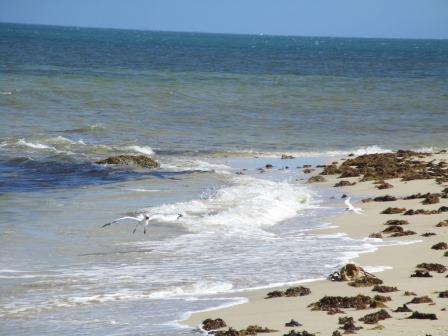
As
we walked up we realised what the fuss was about – a huge lobster head.


Lots
of seaweed floating along the water’s edge and dying on the beach. Spotted a
couple of small turtles and few little rays too – one had lots its tail.

Continued
along the beach then walked up through the few campsites available here. Steve
commented on the wisdom of whoever installed the thin steel bollards as they
are rusting already and this area appears to be recently created.

Headed
back – interesting looking at the tracks and bores/wells marked on the Hema
Maps, reminders of the pastoralists lives out here. It also shows the campsites
which aren’t open now – just for day use.
We
turned into Osprey Bay campground. There are a few more camps filled here and
we can see why – lovely view and easy access to the water for a swim and
snorkel. Nice picnic spot, complete with cute birdie – grassy wren I think.


These
first campsites are up on the rocky hill but it isn’t far to get down to the
water.


We walked along the rocky edge to an opening in the limestone rocks so I could put my feet in the water.


I
had my togs on and it was so lovely I just had to get in. Steve skipped it –
doesn’t like feeling salty afterwards, slack-oh. Only problem is he gets the
camera and then I have a heap to delete!!


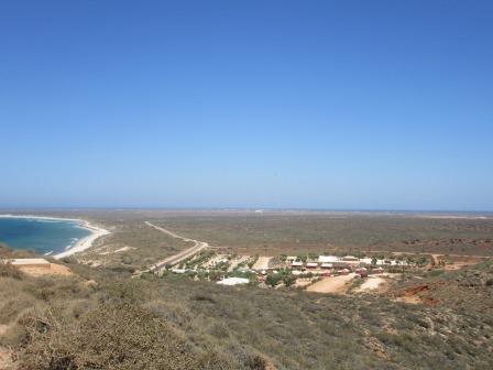
Steve
walked back and brought the truck around to where I was swimming. There was an
information board about the kayak route for snorkelers and it shows the
campgrounds – Bungurra is closed at the moment. This is the aerial shot of the
campground from the brochure.


I
dried off – I don’t feel too salty. We then followed the track past another
section of the campground (camp host in residence here) to Sandy Bay. Looking out
to Sandy Point.


Nice
formed track to follow then we saw the road leading in to it – well the
exercise will do us good.

Lovely
sheltered bay.


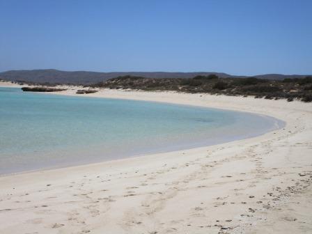
Walked
in the water back around the point. The reef is closer at the point.


Looking
back into the bay with Cape Range in the distance.

As
we rounded the point the coral was close but the wind was disturbing the water
so we couldn’t see any fish.

Looking
back to the bay where I had a swim. Will mark this one as my favourite for
another visit.


Headed
back to the main road. Spotted a track heading up to and up the range so we
followed it in. There are old NP signs here, no camping but nothing saying you
can’t follow the track up. We decided not too after I looked on the Hema and it
goes up and over and comes out at Learmonth – probably part of the old oil
exploration tracks.
Continued
back towards our camp. Turned in Pigamunna Bay picnic area – used to be called
Pilgonaman Bay (obviously the linquists have been here and changed the
spelling). It was an old camping area and was the site of one of the station
bores.
I got out to read the information sign. It told of how the area was washed away with heavy rain in 2014 as there is a creek that comes down from the range that enters the ocean here. There is the old toilet up on the dune but no picnic tables or shelters as mentioned on the sign. Great photos.


Steve
drove down closer to the water.


Followed
Steve out onto the rocky outcrop. Lots of smooth stone washed down from the
range.


Steve
has spotted some bright blue fish of good size which he thinks is the Blue Bone
(like a Tusk fish) that the rock fisherman chase. Named because their bones are
blue coloured. We then noticed a few schools of littler ones in the shallows.


Clam
shells etc are embedded in the rocks. I found a dried-up slug.


Back
on the main road again where we spotted this poor old dingo wandering towards
us. Not looking too well. He wasn’t worried by us driving slowly past.


Went
back to the van for lunch – the locals are enjoying the shade by the toilet
block.


As
we drove out the roos decided it was time to move.

Drove
all the way back up to the north end to check out the lighthouse sitting up on
top of the north end of the range.


Fabulous
view if we don’t get blown off – it is so windy up here that I didn’t bother
with a hat. Zoomed in on the VLF towers. Great information too. The central
tower is higher than the Empire State Building.


A
cute swallow flew nearby to balance on some wire. In the wildflower season we
would be able to see these lovely flowers that look like little birds.


Steve
checked out if anyone was home at the lighthouse – it is 12 metres high. It
first shone its light on the 10th December, 1912.


Walked
around to the other side for a photo including the kerosene hut.

Lots
of information to read.


A
kangaroo was keeping cool below us under the solar panels.


Looking
down on the caravan park – the big roof in the middle was the old lighthouse
keepers’ house.


Vlamingh
Head where the wreck of the SS Mildura lies nearby.


Walked
down the road to check out the other displays. This is the old WW2 radar tower.
The sandbags that protected it back then are still here and are now rock solid.


More
information.


No
rigs or whales on the horizon today as the sea mist is blocking our view. Now
we know the story how the Charles Knife Gorge got its name. Will have to come
back here after we do the Kimberleys to see the whales. We have seen the whales
around Mourilyan ,when we have been fishing, thrashing their tails on the
water.


The
story of the SS Mildura – got this aerial photo from the brochure.


As
we drove back down I took this photo of the track leading south back to where
we are camped.


We
continued around to check out the remains of the SS Mildura. This cairn was at
the start of the track in but there was no information at the car park by the
beach.

Walked
down onto the beach. We are at the northern point of North West Cape so time
for a selfie. The wreck is behind my head.


We
walked around the beach watching the waves roll along the side of the wreck.
There is another ship out to sea but they have the beacon now on top of one of
the VLF towers now to guide them.


Back
to the west side where we stopped at the Jurabi Turtle Centre. Replicas of the
Green Turtle (Chelonia mydas) and the
Loggerhead Turtle (Caretta caretta).


Lots of information – very interesting.


Walked
down to the beach – no recent tracks here.

Quite
hot now so we decided not to go into each of the beach spots. The emus are on
the move too. Still haven’t spotted an echidna here – according to wildlife
signs on the road we need to watch out for them.

We
pulled into the Tantabiddi Boat Ramp where an Osprey was up high in its nest.


Nice
calm spot for a boat ramp considering the wind that is blowing now.


Turned
around and there is a lagoon on the other side. Spotted a couple more Osprey.


Stopped
at Ned’s Campground ground – it hasn’t been updated and is more of a bush
setting camp area well back from the water. We found a nice big Tamarisk tree
to sit under and had a cuppa.


Nearby
is an artesian water point for people to fill up for washing up etc. Two
kangaroos have figured it is a good place for a drink too.


Called
into the Milyering Discovery Centre but it had just closed. The staff have
quarters on the west side of the road. Will come back tomorrow. They have
internet here which is handy if you want to extend your stay as you can only
book online. There was an advert in the window asking for Camp Hosts at Mesa
Campground for Dec to April. Maybe when we have finished touring we will pick
up some of these camp host positions.
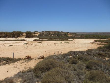
Drove
further along the track to Lakeside which was a camp spot but now only day use.
It probably got washed away when the heavy rain fell as there is a creek bed
here that drains into the sea. It is a popular snorkelling site with several
large bommies to swim over and around. There is a permanent pool here hence the
name Lakeside.


Walked
down to the beach.


Back
to the main road and then down to Turquoise Bay. A shelter shed had lots of information
and pictures.


Walked
over the dune and down to the beach on the southern end of Turquoise Bay. The
beach is covered in broken bits of coral.


The
water was lovely so we wandered along the water’s edge. It looked calm but you
could feel the current pulling us along to the point. A lady was wandering
through the water a bit further out when I spotted a big dark shape heading
towards her. I called out but she didn’t hear/or understand me but luckily it
was just a manta ray cruising by. Another lady snorkelling jumped up when it
came close to her.
The
water is so clear we could easily see lots of fish – whiting, dart, stripeys
etc.


We
walked to the point where two currents meet. A sign warns of the dangers to
snorkelers to get out before getting carried out to sea.


Looking
around into Turquoise Bay itself.


Continued
south then turned off to check out the Oyster Stacks. Another snorkelling area.
Tide height is important here. Doesn’t look to inviting.


Checked
out North Mandu campground – small sites well back from the beach. Mr Dingo was
trotting back along the road – maybe he is ok just looks old and mangy.
Passed
the Mandu Mandu Gorge turnoff then we turned in to check out Bloodwood Creek
Lookout. Bit of a let-down. Obviously someone thought it was worthy of a formed
track and lookout platform.


Back
to the van for late drinks and a few games of Skipbo – Steve reigns supreme.
Walked
up and over to the beach to watch the sun set. The wind has settled.


The
water temperature is lovely so I wandered along the beach in the shallows
watching the crabs come in and out with the waves.


The
sun is disappearing.


Spotted
another type up near his hole.


7pm
27.4 degrees, perfect.
Cool
light wind so closed the windows that side when we went to bed as it gets a bit
chilly.
No comments:
Post a Comment