7am
25.8 degrees, clear sky and very windy. Lots of little wrens and finches are
having fun running around on the roof of the van.
The
wind calmed down while we packed up. View of the bay from sunset seat on top of
the dune behind us. More sea grass has been washed onto the shore.


Back
out the bumpy track to the bitumen then 120km north to Exmouth.
Passed
the turn off into Ningaloo Station – homestead and camping there. Also Point
Cloates lighthouse where 4 ships (Zvir, Fin, Perth & Rapid) were wrecked on
the reefs near it (photo from the tourist brochure). The historical Norwegian
Bay Whaling Station was situated north of the station.

Crossed
into Bullara Station and spotted some cattle up on the sand ridge looking like
a camel train as they wandered along.
Passed
the Learmonth RAAF Base.

Turned
onto a dirt track to the Learmonth Jetty in the Exmouth Gulf (the east side of
the North West Cape Peninsula). This jetty has been rebuilt after damage from
Cyclone Vance. On the south side of the jetty the beach is covered in smooth
pebbles but the north side is just sand.


On
the south side is the Solar Observatory which I zoomed in on – no public
access.

Back
to the main road. Will check out the information etc about the Potshot
Operation and the Krait when we come back down.
Opposite
the Prawn Processing Factory (well that is what it says on the Hema) we turned
into the Cape Range National Park to check out Charles Knife Gorge. Not
suitable for caravans so we unhooked the van near some water tanks. Headed up
the windy road.

Stopped
at the Lookout. This track was built so the oil company could drill on the
range near here.


You
can also see down to the Learmonth Airport and the RAAF Base beside it.


Continued
along the top of the saddle with great views each side.


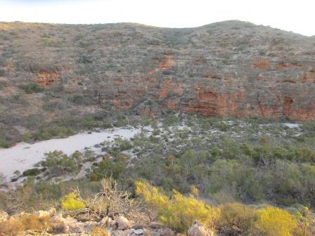
Stopped
to check out this valley and walls.


The
Metrological Station is up here on the range too (320m elevation).
We
followed the track to the No. 2 oil drill site. They drill a long way down for
no oil.


Back
to the intersection and turned off to check out the Thomas Carter Lookout. Not
a fabulous lookout by any means. Bit of a change from the red sandy ridges and
grass.


Lots
of spinifex here.

Some
good caves too.


It
is also the start of the Badjirrajirra Walk which goes across to the top of
Shothole Canyon. A bit hot for that walk today.


Headed
back – looking down on the prawn factory and a bit of the Exmouth Gulf as we
head back down the hill.

Hooked
up the van again and continued north. Passed the turnoff to Shothole Canyon –
will do that on the way out as it says the views are better in the early
morning or late afternoon.
Houses
appearing on acreage blocks on the east side of the road. Turned into Pebble
Beach – same pebbles we saw at Learmonth Jetty.


We
found a couple of interesting ones.


Had
lunch quickly in the van as the sand-flies are bad here too - no wind.
Turned
off into the industrial area to fill up at the 24hr fuel depot – a lot cheaper
than in town. The honeymoon couple we met at Quobba Blow Holes were filling up
too. At last I got their names, Anthony and Tammy with their dogs, Bindi and
Kip. We chatted for about half hour, luckily no one else wanted fuel. The only drawback
of having the dogs is they couldn’t go into the National Park.
Continued
on past a new canal estate and marina which you can see in the photo with accompanies
the history of Exmouth. The road is lined with Poinciana trees that are showing
off their red blooms.


Went
online and booked two nights at Kurrajong Campground, midway down the national
park on the west coast.
Called
into the Information Centre which is also an aquarium and has galleries – En Route
to Exmouth about the history of Exmouth including a shaking room so people can
experience a cyclone. Reef to Range Gallery about the flora and fauna and Cape
Range Gallery which explores the ancient landscapes. We might call in on the
way back – shame we had already booked our national park campsites as the
Centre is free for everyone tomorrow as Santa is coming (normally $19/adult).
Headed
out of town. Stopped outside the Navcommsta Harold E Holt Centre and checked
out the information and the replica submarine. Zoomed in on the new space telescope
building further over on the hill.


Peered
in the door of the submarine.


Further
along the big VLF towers rose out of the ground. Plenty of stay-wires to keep
them up. The centre one (388m) on the concrete block is the second tallest
man-made structure in the Southern Hemisphere.

The
map of this region.

We
crossed over to the west side, will check out the wreck of the SS Mildura and
Bundegi Beach on our way back. Built in 1912 the Vlamingh Head Lighthouse sits
high on the hill. Another thing to check out later.

Headed
south down the coast with the range on our left and sand dunes covered in low
shrubs on our right and the ocean further west.

Lots
of turn offs to different beaches for day use only as we continued south. I
spotted a lone Sturt Desert Pea on the side of the road but we didn’t stop for
a photo – have seen a few hundred of these but this one is very late in the
season.
Past
the homestead of Yardie Station which was handed back to the government as a
conservation park. The homestead though is privately owned and they have a
caravan park there.
Entered
Cape Range National Park, the lady at the entrance hut was just leaving so I
said we had our permit number for two nights at Kurrajong. The park covers
50,581 hectares.
Turned
into the campground area – online it said North Kurrajong Campground was booked
out and half of Kurrajong too but actually they have just closed them for the
summer season. Two other campers are here. There is plenty of room in and
around the sites. Parked up and made a cuppa reading the information in the
national parks booklet. This campground is named after this tree.


Found
info about the Rainbow Bee-eater too.

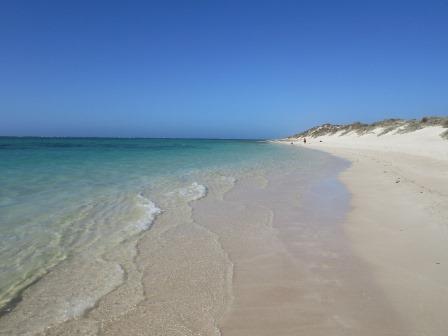
Walked
up the track then onto the boardwalk up and over the sand dune. There is a
picnic area on top of the dune. View back to the van.


It
is windy on the west coast again but the water looks lovely so I put my feet in
for a test – still chilly. The reef isn’t far off the shore.


Wandered
along the beach around the point to where the limestone is exposed.


I
spotted three blue-spotted rays. Not the easiest to photograph as they scare
easily.


Looking
back along our beach.
Went
back to the van and I worked on my blog for a while. Steve went for a walk and
said he spotted rabbits on his way back. We had our drinks and nibbles then
drove back up the road to Mandu Mandu Gorge as the brochure said it was a good
spot to enjoy the sunset from.


Nice
walk along the creek with a cool breeze blowing. The moon is up.


Lots
of smooth rocks and some interesting rock shapes – a skull?


The
walls are getting higher.

Found
the Common Rock Fig and the Cape Range Kurrajong clinging to the side of the
rock wall. Zoomed in on the star-shaped seed pod.


I
had been checking out the bigger rocks and found a shell embedded in this one.


Continued
along the creek bed.


Now
the climb up. We are following those white posts.


Reached
the top – nice view back to the creek bed and back along the gorge as the sun
starts to drop.

The
track keeps going so we kept moving along.


Over
that ridge then down into the valley and up the next ridge.
Looking
back along the creek then to the bend in the creek further along.


Found
a cairn at the turn around spot of the track. Steve added his rock.

A
bit hazy with sea mist for a nice photo of the ocean and reef unfortunately.

As
the sun was still reasonably high we decided we should make our way back before
it dropped and it got too dark to see the rocky track. We had brought torches
just in case but hadn’t realised it was such and up and down track. Heading
back on the high side of the gorge above the creek now.

Continued
along then stopped to watch the sun for a moment.


Further
along stopped for more photos.


Then
it was gone (just after 7pm).

Still
enough light to see as we came down the last ridge. We had brought our walking
sticks again which was great. They are so good for the gravely downhill bits.

Another
fig and kurrajong.


Back
to the truck by 7.20pm then home to our van. A couple more campers have moved
in.
Late
dinner – windy but pleasant. We can hear the waves rolling onto the beach. Cool
enough to close the windows.
No comments:
Post a Comment