7am
26.5 degrees, clear sky and no wind.
Parked
in Robinson Street – got a photo of its width – room to turn camel trains.

Met
Ed and his fiancé Heather for a cuppa. They are getting married on the 18th
January next year, 51 years after their were first married on that date in
1969. Heather showed me a photo of their first wedding day. Sad story but
wonderful they are back together again. Ed forgot the coffee shop he chose is
closed on Tuesday. He wanted to go there as he made the fabulous timber tables.
I took a photo through the window. He loves his woodwork and sells items at the
markets. He signs them Ed Wood. We walked further along to the next café.

Ed
was here in the early days working at the Tracking Station in the 1970s and he
has heaps of stories. I said he needs to write it all down as it was
fascinating. One time the Casshorn Antenna which they call the ‘sugar scoop’
was being used to track and move a satellite into orbit when they were hit with
a storm and a lightning strike hit the main generating plant so they couldn’t
move the dish around. The gearbox also failed so they had to use a Toyota with
a winch to pull it up and down and then pull on the stay wires to turn it. They
did this for the next four days or so till the satellite was in the correct
orbit – Aussie ingenuity at its best.
He
was also in the Navy and had some great stories about that too. Especially when
a shell was loaded incorrectly into the big gun and caused it to jam. It was
because they swapped guns and the left turret guys had to practice in the right
turret which they have to lift and swing the parts in a different direction
hence the shell was placed in backwards. The projectile was a separate thing
and then a sailor hit a button (breach loader) to push them together into the
barrel of the gun. Luckily they were only practicing and had time to be able to
work out how to get it back out again.
He
was a town councillor till just recently and has many interesting stories to
tell. Especially about creating the two memorials at the end of the street for
the HMAS Sydney II and the HSK Kormoran. Also there was a memorial drive
(alternate route into town) where they tried to grow palm trees with a plaque
for each of the 645 sailors that drowned. He and a couple of other people got
all the plaques, cleaned them up and then glued/nailed them onto the brick
walls on the water side of the walk way hence we missed seeing it.
Walked
with them down to check out the HMAS Sydney II sailor plaques. Listed
alphabetically they continue along the foreshore to the parking area on the
point. It was opened in 2016 to commemorate the 75th anniversary of
the sinking of the ship on 19th November 1941.


The
Memorial cairns which Ed was involved in organising. The anchor came from over
on the east coast as there aren’t too many of these types about. It weighs 2
tonne but a freighting company owner who was involved brought it over for free.
They positioned the anchor to point to where the ships are lying.


The
Kormoran cairn is set back from the Sydney one to symbolise its position in the
ocean where they both lie on the ocean floor.


Said
farewell to Ed and Heather and wished them all the best for their wedding next
year and the further years together. Will send them a text on their wedding
day.
We
grabbed some fruit and vegies then topped up with fuel and swapped a gas
bottle. Back to the van for an early lunch in the shade of the tree as it is
heating up.
Hooked
up then drove around to the Carnarvon Space and Technology Museum. It is on the
site of the OTC Earth Station which is on the northern end of Brown Range. The
museum was created by Phil Youd. He had bought the local radio station in 2011
and saw the satellite dish on the hill. He did some research and discovered
there was a tracking station here too. He founded the Museum not knowing of
Carnarvon’s connection to NASA’s space program. He just thought it would be a
good tourism draw card for the town. Through fundraising, hard-working
volunteers, a ‘good deal’ with the owner of the small building which would
house the museum originally, Phil’s indomitable spirit and vision, the Space
& Technology Museum opened a year later.
The
OTC Earth Station was opened in 1966, initially with the 12.8 metre wide
Casshorn antenna as part of the global satellite communications system. The
Earth Station was expanded in 1969, when a second and larger antenna was
completed. The antenna had a diameter of 97 feet (almost 30 metres). It took
over the job of the original 42 foot antenna in relaying NASA communications
via the Pacific Ocean. The Tracking Station was located 4km south from here. This
station was built to support NASA’s Gemini, Apollo and Skylab programs. It was
commissioned in 1964 and operated for 11 years. It was the last station to
communicate with the space capsules leaving the earth’s orbit and the last in
contact before splashdown. At the height of the operation it had a staff of 220
people. It was the largest manned space flight tracking station outside USA.
A
mobile laser was used pinpoint Carnarvon’s position on the earth.
The
Museum has been developed in stages and opened by NASA astronauts. Stage 1 in 2012
by Buzz Aldrin (Apollo 11) then Australian born Andy Thomas opened Stage 2 in
2014. Finally in 2016 Stage 3 was opened by Captain Gene Cernan, Apollo 17
astronaut – he was the last man on the moon as commander of NASA’s final Apollo
mission.

A
volunteer collected our fees. I checked it was ok to take photos.
She
showed us to a life size capsule of Apollo 11 for our journey to the moon. We
climbed in and put our feet up on the shelf. Above us was a TV screen and there
were two windows on each side which the astronauts looked out of. There was
also a window in the door the chap informed us. The 7 minute video took us
through the launch process then the countdown to take off with actual voices
from the day. It was very good and there were even sky then flames (from the
different sections breaking away) out the windows as we roared off into space.
I took three videos too.


We
walked down a corridor filled with photos of Buzz Aldrin and the moon landing.
Neil Armstrong’s reflection is in Buzz’s visor. A view of the Earth from Apollo
11. The two astronauts putting up the American flag.


We
went into the third stage section which is a hands-on science activity area.
Info about other space exploration and down the corridor was photos of our
solar system – without Pluto of course.

We
weighed ourselves on a huge scale – it is 5kg underweight or our scales are 5kg
over!! I tried flying and landing the space shuttle, got touch down then soured
up into the sky again – that was a fail! Steve just posed for a photo.


There
were things to show weight distribution, static electricity and videos of the
Apollo 11 flight to the Moon. Took a photo of us on the moon which was then
emailed to us.

Back
to the main area to read all the info, watch videos and check out all the displays.
There are lots of special machinery on display.


One
of the iron meteorites that landed around Mundrabilla Railway Siding on the
Nullarbor Plain. The largest, found in 1966, weighs 12.4 tonnes with a total
mass recovered of over 20 tonnes. The meteorite is composed largely of
iron-nickel metal but the iron sulphide near the surface of the meteorite
melted as it plunged through the Earth’s atmosphere, leaving holes.

There
have been 5 different groups of manned space missions.

The
first group of missions were called Mercury (1958-1963) – the beginning of the
space race with Russia to put a man in orbit around Earth. The USA lost, Russia
got there first, 12 April 1961, with Yuri Gargaran. Muchea Tracking Station
north of Perth was used for these missions.


It
was then the Gemini missions (1965-1966). Carnarvon’s Tracking Station was
created.


This
is a full size Gemini capsule mock-up. There was a video playing in the cockpit
showing an astronaut making the first walk in space – he enjoyed it so much he
didn’t want to go back inside. It was also the first time two spaceships were
in orbit at the same time. They came together to practice docking procedures.
In the video you can see the astronaut waving through the window.


Then
came the Apollo missions (1968-1972) of which No. 11 achieved the goal of
landing men on the moon on 21st July, 1969. The ‘Sugar Scoop’
outside relayed the images of Neil Armstrong’s first steps on the moon from
NASA’s Honey Suckle Creek Tracking Station to Perth’s RV audience via the Moree
earth station. They held a cocktail party this year to celebrate the 50th
anniversary of that amazing moment.


Skylab
(1973-1974) was next. We saw replicas of it at Balladonia on the Nullabor
Plain.


Then
the Space Shuttle (1981-2001).
More
interesting information about communications. This shows how the transmissions
of Neil Armstrong’s first steps on the moon were broadcast around the world. An
old TV shows the first satellite TV broadcast from England talking with people
in Carnarvon.


Info
about the different equipment used here.


From
then the satellites continue to go up and provide us with communication all
over the world.


From
the moon they are now reaching further into space.


The
Space Station – we have seen that heaps of times shining brightly as it zooms
above us. Video footage of its view of the world.


The
antennas used to track all those satellites.
A
video was playing of memories of local people and the staff of the Tracking
Station and OTC Earth Station. Lots of stories, photos and signed memorabilia
from when the astronauts visited here.


There
was a cinema too which short movies on various aspects of space travel, NASA
and Carnarvon’s involvement in it all. It was very informative and we managed
to see everything in the 3 hours we have been here, when the chap announced it
was time to close.
A
long board near the exit shows the time frame of space exploration.


Outside
we checked out the original ‘Sugar Scoop’.


More
antennas and The Dish which has a 29.6 metre diameter and weighs 300 tonnes.


As
we were driving out I spotted the water fountain made by one of the tracking
station staff in the 60s.


Also
the full size replica of the Mercury Redstone rocket. It was opened by NASA
flight director Gerry Griffin on 20 May 2018, celebrating the first US manned
mission into space and honouring the first astronaut in space, Alan Shepard.

Drove
down the road and pulled over for a cuppa before we headed out of town. Crossed
over the Gascoyne River again as we headed north on the highway. Turned off
onto Blowholes Road which was bitumen. Through flat salt bush country between
low sand ridges.
Reached
the southern end of Lake Macleod which is a huge dry salt lake which covers
2,072 sq km and is 110km long and 40km wide (one map that actually says this
lake is dry). Rio Tinto operate the Dampier Salt Mine near here and a Gypsum
Mine further north on the west side of the lake.


Further
along we stopped to check out a pink waterhole and sheds. This is where they
produce Beta Carotene.


Entered
Quobba Station land. Reached the ocean again with a big sign reminding
travellers of the dangers of these waters.

We
turned left towards the Blowholes and campground. The lighthouse is perched on
top of a sand dune (Beagle Hill) further inland.


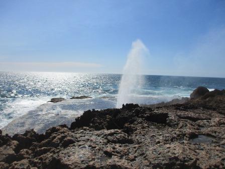
Saw
a spray of water shoot up as we approached the rocky ground near the blowhole
site. At least this one is working. A plaque reminding people of the dangers of
rock fishing.


A
squirt of water shows us the way to the blowhole.

The
red limestone rock is smooth under our feet but very rough and sharp further
across. Nice platform below as we head across to the blowhole.

Thar
she blows.
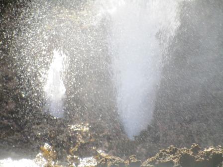
I
went closer being very careful on the very sharp rocks here – luckily I had my
boots on, not thongs. The platform on the other side of the blowhole also had
little blowholes. Of course this is closer to the water compared to the ones in
Edel Land NP and there is a good swell today. Luckily the wind is blowing the
water away from us.


Looking
back down the coastline.

The
blow hole is in a gully further over – carefully peered over. There is another
smaller one beside it. Took some videos and a heap of photos of which I have
just chosen a couple – the joy of digital cameras.


Drove
around to the campground where there are a number of tin shacks used by the
Carnarvon locals. There is a bit of controversy with them as some of them
needing pulling down due to safety concerns. A line of vans was parked on the
high area.


We
continued along the track. There are 42 shacks in total as they each have a
number on the walls.

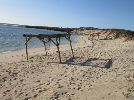
We
parked at a spot behind a dune and walked over the dune to the water. Looking
south then around to the north. Point Quobba is a bit further around past where
the other vans are parked. There is a bay there that is called The Aquarium –
good for snorkling. No fishing allowed there. The point sticking out further is
an island out from the actual point.


Looking
back over the southern end of the shacks.

A
cute bird was swinging on the rope.

We
parked in a wide open spot with hard road base with the track going past below
us. Track up the dune to the beach and a big dune on the east side.


Set
up camp. Still windy but not as bad as it has been.

Put
on our hats and headed down the beach for a walk. Lots of sea grass around.
This section is thick with it.


Around
the end of our bay – looking at the island off Point Quobba or is it part of
the point. Looks like it all joins up on low tide.


The
Aquarium – filled with coral, fish and shells supposedly, but I don’t think we will
be swimming and we have the best coral on the Great Barrier Reef. The shelters
really are lean-tos.

Big
waves are rolling over the rocky shelf that goes out into the sea from the end
of the ‘island’.


We
walked up the where the other vans were parked and chatted with a guy. He had
NSW plates but has moved to Bargara near Bundaberg. We said about Woodgate and
he said he nearly bought the block of land opposite the pub there. Small world.
He noticed Steve’s Minelab cap and said he detects too. Chatted about different
areas etc as he is staying over this way for a couple of years to detect. Cute
little bird wandered over to us.

Walked
back to the van for drinks and a few games of Skipbo. We can see over the dune
to the water from our window.

Headed
back to the blowholes for sun set. A big goanna wandered across the road but
got into cover before I could zoom in on him. Probably the biggest one we have
seen.

Drove
around to Point Quobba first. Map shows this is the point and the ‘island’ is a
rock platform. Pebbles cemented into the limestone rocks.


Little
waterfall happening as the waves dump the water on top of the rocks. Lots of
salt pools here too.


Chatted
with a young couple on their four month honeymoon trip. They are from Bowen.
She loves photography too so we snapped away as the blow holes blew while the
guys chatted about travelling and prospecting. He works for a gold mine near
Bowen. The tide is lower than this morning so it is sucking out well and
blasting the water up through all the holes. Got some great videos too.


Back
to the van for a late dinner and movie. The wind is still blowing butt not as
hard as previously so we can leave the windows open. The waves are pounding
onto the beach.
No comments:
Post a Comment