7am
16 degrees, foggy & overcast. After breakfast the sun came out a bit and we
went off looking for agates. Smashing the rocks with hammers to see the colours
inside.

Found
a few nice bits of colours and some interesting green ones.


Had
a cuppa and some date slice. There were ants working around their hole so I
dropped a bit crumb near the hole. Fascinating watching them work and how crazy
they are with navigation. Some would pull off a bit of the crumb then wander
off away from the hole but eventually they would make their way back then go
down the hole. One bit my toe so I stomped on him but another picked him up and
headed back to the hole. Another ant tried to grab the dead one so the ant
headed off in another direction and it was a good 15 minutes of him wandering
around with this dead ant in his mouth before he made his way down the hole. I
then put the crumb over the hole entrance and we watch them trying to rock the
crumb off the entrance. It was a very entertaining half hour!!
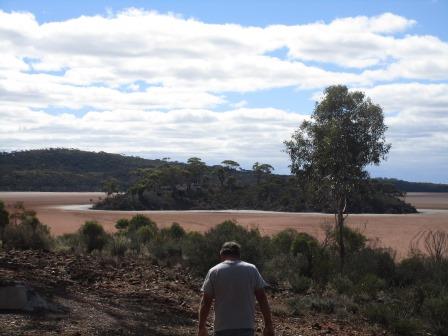
Packed
up and headed back towards Norseman. Turned off and climbed up to the lookout
for lunch. Great view of Cherry Island and a small part of Lake Cowan. Would be
great to see with water in it.


The
chap at the Museum mentioned camping on Cherry Island and along the Woodlines –
now I know what he meant. Timber was vital to everything in the old days –
cooking, heating, boilers to run machinery etc so hence there was always the
timbergetters. Not having big trees to get their timber from the men had to go
out further and further to get the timber so they set up rail lines to
transport the timber back.


Zoomed
in on the Phoenix and Butterfly tailing piles with the headframe of the other
mine behind.


As
we crossed over the lake it looked like water in the distance, you can
understand why people who were lost and thirsty would keep walking thinking
there was water ahead.

Back
through Norseman then headed north towards Kalgoorlie. Leanne rang to say they
were home again and had a fabulous trip through NT. The highway is running
beside the railway and water pipeline. We got passed by our first road train.
Then we saw the name on the back and it was Blemmers of Far North Qld. Should
have said hi but Steve thought they had gone under and maybe the trucks were
sold to someone over here.


Passed
a few mine haul roads all with big signs advising us of road trains turning etc
– they can up 53.5m long. Steve commented that the road isn’t as good as the
Nullarbor one. Passed Widgiemooltha Roadhouse – had a big gold rock outside but
we didn’t stop. Turned onto the Goldfields Highway to Kambalda (rather than
going up to Coolgardie). Found the golf course and played our last hole of golf
as the next two are in the posh Kalgoorlie Golf Course. Will drive up to the
lookout to check out Lake Lefroy.

I
haven’t improved much as I still miss the ball a lot!!


Steve
sent it flying but we both ended up off to the left in the trees!!


I
zig zagged my way down getting stuck in another bush but finally made it onto
the green or black as it is here.


Steve
got a 9 and I got 7 – not bad to finish on. Chatted with another couple who
came after us. Took a photo of our score card. It was fun and something to look
forward to on the trip.

Back
across the highway to the Info rest area for a cuppa and to check out some
machinery on display.


The
Info Board needs an update. It was originally founded in 1897 as a gold mining
town during the Goldrush frenzy but it was all but deserted by 1908. It became
alive again during the 1960s nickel ‘boom’, which resulted in the discovery of
one of the world’s largest nickel sulphide deposits in the area and the opening
of Australia’s first nickel mine.


Lake
Lefroy is also famous for landyachts.

The
Arts Centre is only open on Sundays but we could peer in the windows.


Lots
of photos of the woodlines.


Steve
was impressed with the 3D picture on the wall.


A
couple of nice murals on the wall.


Drove
up Red Hill (394m – town is 310m) to the look out. Zoomed in a plant –
presuming it is nickel.


Then
scanned around over the tailings piles and across Lake Lefroy. Amazing – would
be fabulous to watch a landyacht race here.


Zoomed
out for a panoramic view.

Info
board.

Walked
further around to look across the other side of the hill. They mine the salt
here too, which we think they are doing down there. Amazing they don’t sink in
the mud underneath.


Further
down the track and another view.


Zoomed
in on mine areas.


The
communications tower looks like an old headframe. Maybe there was a shaft
underneath it. As we drove up there was a sign saying ‘last gold mine closed in
1907’ – maybe it was this one.


Drove
around trying to find the Miners Memorial Garden – not a sole in sight. Found
out later it is in West Kambalda (now the main part on the other side of the
highway).
Nearly
at Kalgoorlie as I saw the tall stack of the Kagoorlie Nickel Smelter. Stopped
at a rest area for photos with the big bowls. Someone has painted the inside.


Map
of Kalgoorlie-Boulder – two towns joined to make one.

The
huge tailings piles of the Super Pit come into view as we head into town.

Parked
the van at the Centennial Park 24hr RV Stop. A few other vans are here too.

As
the sun was starting to set we drove through town and up to the Super Pit
viewing area. Lots of lovely old buildings here.


Onto
the Goldfields Highway again. Passed the old headframe of the Cassidy Shaft,
now used as an emergency entrance to the underground mine.

On
our left is the tailings piles over the area of the Historic Golden Mile.

Passed
the entrance to Boulder – the other half of the city.

Up
the mine road to the lookout as the sun started to drop over the city.

Still
enough light to see down the 600m into the Super Pit. It is unbelieveable. Big
trucks were driving up and down and they looked like little Matchbox cars. A
chap beside us said they drive down at 30km/h but only 10km/h uphill fully
laden.


Zoomed
in where they were working way down below. A truck was spraying water on where
the endloaders were scooping up the rock to put into the trucks.


Walked
over to the fence for a view over Boulder.


A
big truck being worked on.

I
stood on top of big tyres filled with dirt for a view of the setting sun. Glad
we bought our jumpers as it is a bit chilly up here.


Inside
the shelter was heaps of information – part of the Golden Quest Discovery Trail
that goes for 965km – starting at Coolgardie and ending here.


More
info about the Super Pit and Mt Charlotte. Very interesting reading.


Fabulous
aerial photo – there are two in the info brochures I will take photos of too.

The
lights are on and the mine keeps working. The criss-cross markings are where
they are going to do a blast.

The
TV screen said there was a blast today at 1pm but maybe they had to postpone.
The video showed a blast, just in case we miss it.


The
chap pointed out where some slips have occurred.

Had
to imagine this great hole used to look like this – full of little mines
digging down into the earth. As they excavate they come across all the old mine
shafts.


Last
look over the Super Pit and the evening glow over the city.


The
moon is up as some others get a photo in the big bucket. Will be back to
explore the machinery in the daylight.


Rang
Gavin to arrange to catch up tomorrow. Steve had TV reception but there is
nothing good on to watch!!
Fabulous
start to our Gold Trail with sunset over the Super Pit.
No comments:
Post a Comment