A
bit warmer this morning, 17 degrees and the wind has dropped off.
Headed
into Meekatharra for fuel and to chat with the Mines Office chap. Spotted a
wedged tailed eagle on some roadkill in the distance so Steve slowed down so I
could get a photo. Got him but missed him flying off.

Got
all the info and a few more spots to check out from the nice chap at the Mines
Office. Stopped at the Information Bay to fill up with water and have a cuppa.
Chatted with some others as they pulled in for a cuppa too. The old stamper
from the State Battery and other mining relics around the parking area.


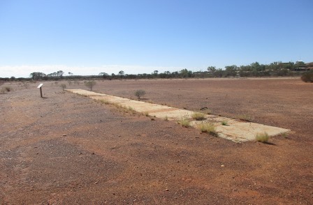
In 1890 JF Connolly discovered gold 50km south of here – wonder if that is where we are!! Meekatharra was gazetted in 1903 and as usual lots of hotels, churches and basic houses sprang up as the gold prospectors came to find the gold. ‘Meeka’ is now a major service centre for local mining and pastoral industries. Its central position in the State has made the airport an important refuelling stop for light aircraft as well as the RFDS. The airport has a huge 2181 metre runway which was built by the Americans during the war. There is even an outdoor picture theatre.


In 1890 JF Connolly discovered gold 50km south of here – wonder if that is where we are!! Meekatharra was gazetted in 1903 and as usual lots of hotels, churches and basic houses sprang up as the gold prospectors came to find the gold. ‘Meeka’ is now a major service centre for local mining and pastoral industries. Its central position in the State has made the airport an important refuelling stop for light aircraft as well as the RFDS. The airport has a huge 2181 metre runway which was built by the Americans during the war. There is even an outdoor picture theatre.
It
is part of the Gascoyne Murchison area and there are a few trails to follow
from here too.


One
is the Kingsford Smith Mail Run from here to Mt Augustus and out to Carnarvon.
Hard to imagine bouncing over the old dirt roads in this old truck.


The
Meeka Rangelands Discovery Trail (3km) heads off from here so on with our hats
and off we wandered along the Meekatharra/Lukes Creek (it shares two names).
Will have to keep a lookout for a euro/bigurda.

This
billabong is kept full with water pumped from the old abandoned open cut mine
nearby. The creek is normally dry but flows well during heavy rain.


Followed
the boardwalk (needing repairs) passed an old headframe but no signage about
it.

The
boardwalk runs beside old Belele Road. You can still see the rock edge.


Certainly
warming up as we walk along the creek. Nice and cool in the shade of the trees
though.


Unfortunately
the Council provides lovely brochures about this trail but they haven’t
maintained the signs and the boardwalks. No. 6 board was missing which was about
the bakery which still continues today. Paddy Durrigan’s ‘Smithy’ sign was
nearly unreadable.


The
telegraph line.


Some
are getting so faded. The Camel Soak.


Crossed
over the dry creek bed and headed back down the other side. An old mine used to
be here.


The
vast Red Rangelands covers 850,000 square kilometres.


We
walked past quarters etc for a mining company completed protected by high
fences and electric fencing.


It
is near the old sporting grounds – the old cricket pitch.

Luckily
we have our toilet in the van otherwise we would be just like the old days with
a hole dug in the ground for our toilet!!


The
school looks bright and fresh a lot different to the first school here in 1904.
They didn’t even have water or a toilet.


The
info board was missing from this one which was about the local policeman
patrolling the streets on his bicycle. Looks like they have a road training
area here for the kids on their bikes.

Interesting
plant with pretty flower but nasty looking spikes.


Don’t
think it an edible one like this one.

How
the fish and frogs survive in the dry creek before the billabong was created.

Back
to the truck then we drove up to the lookout. Got a text from Rochelle who is
enjoying all the Kalgoorlie photos are she and her husband Lindsay worked there
for a while. It is on the tailings dump from the open cut mine where the water
for the billabong comes from. Another nice lookout picnic area like the one at
Norseman.

Great
cut outs though I don’t think they have finished pushing out all the bits.


Lots
to read. Interesting to note that by 1910 there were 2400 people living here in
870 ‘dwellings’ but by the 1960s is was all over. Gold had bottomed out to $32
an ounce in the early 1970s. Glad it has risen again.


In
1994 Luke’s pit was dug below us and a new hill was created that we are
standing on. They got 18,000 ounces of gold.


The
view over the new sports grounds, over town and across the pit.


We
walked around the edge of the hill following the path. Looking south over the
red land towards the massive tailing dumps of Bluebird mine in the distance.


Further
around looking west.


Steve
and I were discussing this big power plant as I had read that Meeka was the
first town in Australia powered by solar energy. In 1982 a solar-diesel power
station was built near the town. It was the largest of its kind in the world
but it has since been decommissioned. I would have thought solar would be
everywhere out here as the cost of transporting the diesel is a lot more
expensive. As we headed back around the other side of the hill we found the
answer on the info board.


Back
to the truck then we headed down to the road again and a bit further out of
town to the turn off to Peace Gorge. Originally called ‘the Granites’, its name
changed after a picnic to welcome the servicemen returning home was held here. The
flat area opens up with a ridge on the right then huge boulders sticking up
everywhere. Lots of area to camp but in the main area there were heaps of
smashed bottles so maybe we won’t stop here.


Continued
around the tracks where there were plenty of other cleaner areas to camp.


Back
out to the main road we went across the road to a big cave which the ‘locals’
use a lot.

Heading
over to the ‘cliff’ area – this one looks like Australia.

We
climbed up onto the ridge.

Good
view over the ‘gorge’. Lots more granites further on.


On
the other side we look back to the lookout on the man-made hill.


Steve
thinks these are goanna holes.

Back
through town to check out the Eastern Loop Drive Trail though I don’t have any
info on it other than the signs we saw coming into town. Turned off at the
first sign which was to the old cemetery. Very neat and tidy and had lovely
clean toilets. Lots of flowers on the graves and obviously they are respected
as the graves are covered in lots of ornaments etc and they are all still
there!! Didn’t actually find the ‘old’ section.


Next
stop was the old Government Battery site. So sad it wasn’t kept as a tourist
attraction. It was here for the little miner and ran the depression and the
wars crushing the rock for the miners. 208,000 ounces of gold was produced out
of all the rock crushed here.


Now
it is just a mess of broken bits and pieces. What is left of the battery, ball
mill and workshop. The stamper is now at the Info Park we saw before.
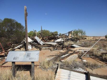
A
plaque shows where things used to be.

Tailings,
cyanide treatment plant and the carbon-in-pulp treatment sands.


Mind
you with all the cyanide treatment plants here it’s amazing it is open to the
public.


The
Moment of Truth when the miner waits for the manager of the battery to announce
how much gold was in the ore they just crushed for him. Some were happy, for
others it was the end of them.


Hard
to imagine how it was from the direction plaque.


But
the solid concrete seat was still there where they weighed the gold in the main
office.


Back
towards town and the sign pointed us up a track to where the water reservoirs
are. The biggest challenge for everyone in the outback – getting enough water.


Good
view over the town from here too.


Looks
like a ‘local’ hangout. Across from it we saw fenced houses with a sign about
‘alcohol free zone’. Though a lot of the fencing was missing as it was a
plastic panel that the kids must use to slide down Tank Hill as there were
panels everywhere.

Headed
into town passed the old railway area where a 24hr fuel bowser was. The couple
we saw at the lookout were there filling up so we enquired. It was 135.8c/l
which is 10cents cheaper than the Coles Express, unless you spend the $20
instore to get the 10cents off!! So we topped up here. Headed back out of town
passed the Blue Bird Mine. We stopped at the end of the open pit where we could
climb up for a look in – no fences here.


Decided
to drive back to the entrance as I had seen a big rock with a plaque. Didn’t go
in though.


On
the other side of the road was another big open cut but it had a fence around
it.

Stopped
to check out the Vermin Proof Fence. It was marked on the Hema map so it has
been there for a while but looks like it has just been redone. Will have to
google it. Looks like the dingo would follow the fence along then end up
corralled here but they haven’t finished the corral section yet so they can
just run back out.


There
are special gates to allow the cattle in but not out.


Looks
like it’s not just dingos – this looks like an emu feather.

Passed
the old Caledonian Mine.


Turned
off the highway following the Nannine Township sign. Through a new fence here
too.

At
the railway station we found an info board and lots of bits and pieces people
have lined up on the concrete platform. The old sandstone under the platform is
still hanging in there. Lake Annean in the distance.


Another
trail to follow – the Miners Path.

The
chap at the Mining Office said that most of the township is now under the
tailing piles.


Kate
and Tony we met in Laanecoorie told us about a shed they camped in around here
while they detected. They found a heap too. Drove around following the old
railway line on the Hema map. A couple of old cars are all that’s left.

Around
another tailings pile we found the shed. Someone had their camper there so we
drove down to see if anyone was home.

No
one was so we went for a walk. Looks like this was the site of the mess or
something as there was plenty of concrete slabs and paths.


Walked
to the edge of the area to look over the salt lake area. Had to tell what is
natural and what has been created from the mining.


Inside
the shed people had marked their ‘gold’ scores. Found Kate and Tony’s tallies.


Someone
else isn’t happy about people prospecting here.

Drove
further around following the rail line then up another ‘hill’. Nice view.


Went
back towards the ‘township’ and climbed up to check out the pit.


Looking
back up to the road where I took the photo from before.

A
car headed back towards us from the salt flats and headed down to the shed so
we went down to say hello. Jeff and (forgot her name) were from Rocky and have
been here before. He told us of a story of a chap with a special salt coil on
his detector who found 30 ounces of gold in the salt. Unfortunately his son was
sick so he had to leave. He sold the coil to his mate for $400 and that guy
went out and found a further 26 ounces!! We wish.
The
sun is setting so we headed back to camp as Steve still had to cook tea in the
bushcooker!! Snapped a couple of photos as we drove home.


Certainly
was a hot day, it was 30 degrees in the van when we got back at 6pm, though I
did have all the windows closed and only the roof vents open.
Watching
the trucks zoom by we saw flashes to the north. After a while we realised it
was lightning low on the horizon. Hope it stays there!!
Googled
the Dingo Fence – Found this from a news item in March 2015.
A West Australian grazier is warning there will be
nobody left grazing sheep in his area, unless funding for a new wild dog fence
is confirmed.
A group of shires in the Murchison region have
requested just over $4.5 million from the WA Government through the Royalties
for Regions program to build part of a 480 kilometre vermin proof fence.
The cell is a proposal to build a fence connecting
the Number Two Barrier Fence, south-east of Meekatharra, across to the State
Barrier Fence north-east of Mullewa, fencing off 88,000 square kilometres of
land. The cell would enclose 55 pastoral properties.
No comments:
Post a Comment