7.30am
19 degrees, clear sky and still. Packed up and said bye to Jim and Kay. Sent
Rick Mitchell a birthday message for today.
Back
onto the highway continuing east following the pipeline. Through more road
works where the water truck was keeping the dust down.
Stopped
at the site of ‘Gilgai’ the 7th Pump Station rest area.
Unfortunately it and the houses has been demolished due to asbestos. No. 2 pump
station has also been demolished. Read the info and stories of the people who
lived and worked here.


Continued
along then turned off and followed the dirt road to the townsite of Woolgangie.
The pipeline has gone away from the highway here. We followed the road that
leads to a rock further north then we found a sign on another dirt track
leading to the townsite. I walked down one side of the pipeline and Steve drove
over the pipeline and down the track on the other side. There was a caravan
parking sign but nowhere to turn around!! The track continues on to No. 8 pump
station but is not recommended for caravans.
We are parked where the railway line would have been.

Steve
came over the ladder and we checked out the info and the remains of an old
home. Very hard to photograph let alone read these shiny metal signs. In the
summer of 1895 this railway stop ran dry so a telegraph was sent the Premier.
Eventually special water trains were sent out then the pipeline was started to
alleviate the problems across to Kalgoorlie.


Up
and over the pipeline – looking to Woolgangie Rock which has a water catchment
wall around its base too. The big water trucks have been coming in to get more
water for more road works.


Lots
of patches on the pipeline – each marked with an initial and date.


Steve
found some space to turn around and we headed back. Zoomed in on the water
trucks.

Back
over the pipeline. Only some concrete foundations left of the telegraph
station.

My
brochure said that ‘Dedari’ No. 8 was open and had a caretaker but when we
pulled into the rest area the information said it was now closed too due to
asbestos. It is 5km off the road and we saw dust of another water truck going
in to get water from the dam so we decided not to go in.


Continued
on through Bullabulling. The tavern was established in 1897 but has recently
closed. It is located at the base of another large granite outcrop which
provided water for those on their way to the goldfields.


The
new road is much nicer. Approaching Coolgardie we turned into the Camel Farm
and spotted a couple in the distance behind the houses but the road was closed.
Coolgardie
– the Mother of the Goldfields. The name Coolgardie is said to be derived from
the aboriginal word ‘Collcaby’ which refers to the area’s mulga vegetation and
gnamma waterholes. Over the years, Coolgardie has been known by various names
such as Bayley’s Find, Fly Flat, The Old Camp and The Old Diggings. Coolgardie
was the first settlement in the eastern goldfields. After alluvial gold was
found in 1892, Coolgardie grew in 10 years to a town of 15,000 people, 23
hotels, 6 banks and 2 stock exchanges. The main street was made wide enough for
camel trains to turn around in. The heat and isolation led to innovation, in
this case that of the Coolgardie Safe, which used water and a breeze to keep
food cool before days of electricity. Twenty-three buildings have been listed
on the National Estate register.

Some
interesting houses as we drive through. Wheels and beer can patio fence.


Drove
around to the railway station where a 24 hour RV Stop is located. Saw a
Bushtracker and through it was Greg. Chatted to the lady, Belinda. She and her
husband, Max, detect and are from Qld. He was out on some pending ground trying
his luck.
Set
up then checked out the info about the railway station (1898-1979) which used
to house a museum.


Peered
inside.

Parked
on the main street next to the park.


Wandered
up and down the street reading all the information plaques.


Inside
the museum housed in the Warden’s building, I checked out a replica of a nice
nugget I would like to find, called Thunderbolt. Found in Kalgoorlie region in
2013, weighing 119oz.

The
Golden Quest Discovery Trail starts here on its 965km trail up through the
goldfields district and back to Kalgoorlie.


Continued
on with the town plaques.


Very
wide street.

Nice
pressed tin ceiling in this old shop.


Don’t
sit on the window ledge at Ivory’s Corner, est 1896.


More
history.


Crossed
the road to more hotels.


Lots
of banks too.

Walked
around Prior’s Park, an open air museum collected by Ben Prior throughout his
life.


More
info as we headed back to the truck.


Nice
painted shovel.

Now
that’s interesting.

More
hotels.


Looking
down the street to where we are parked (on the right).

Great
play on words – Gold/Ghost Mining Town!!

Camels
and water were very important in the old days.


The
Warden’s house.


A
‘pool’ as tribute to C. Y. O’Connor.


Up
to the Lions Lookout. The view Bayley and Ford first saw in 1892 as they rode
in from Gnarlbine Soak looking over to where they first struck gold – the area
they called Fly Flat (because of all the flies). This is the Bayley’s Reward
Goldmine headframe.

Looking
back over town, mine tailings dump which become new hills with Fly Flat behind
that, then down below the lookout and then south to more mine areas.


Finnerty’s
Dam made from a gnamma hole.


Another
lovely home and garden.

Back
to the van for a cuppa and chat with Mark and Belinda. They had their one night
here so will keep heading towards Kalgoorlie. I said we will stop at Lake
Douglas so might see them there.

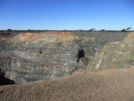
Headed
up to Lindsay Mine lookout – big open pit. Obviously not used any more.


Steve
spotted some sparkle and got out his pinpointer to see if it was gold. It sounded
off so he chipped some off and will crush it to see how much is in there.


I
found more on another big rock – too big to throw in the truck!!

Drove
back through town then down the Esperance Road to The Gorge. It was once a
significant local water source prior to completion of the Perth-Kalgoorlie
‘Golden Pipeline’ in the early 1900s. Nowadays it is a popular picnic spot.


Back
to the main road to Fly Flat, where it all began.


Back
to the van for a drink and get ready for dinner. A motorhome pulled in. All
quiet.
About
9pm an alarm went off for a while, like a mine one but then all was quiet.
No comments:
Post a Comment